

Former Farm of the Premonstratensian Abbey of Bucilly
No reviews yet
Have you flown here? Share your experience with other pilots.
+ Write the first reviewHistory
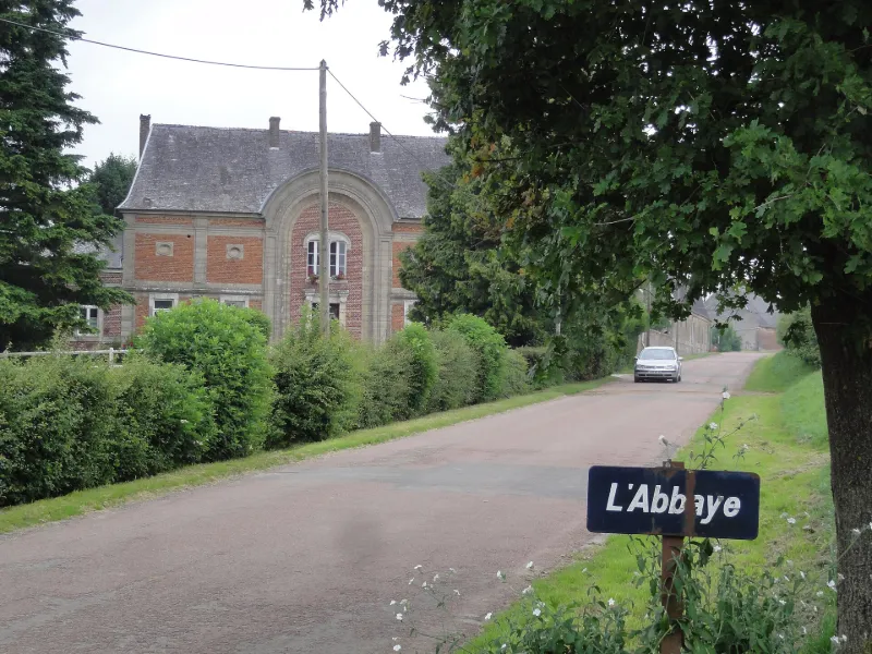
18e siècle L'importance de cette abbaye prémontrée égalait, à la veille de la Révolution française, celle de Saint-Michel-en-Thiérache. Son démantèlement par la suite l'a réduite aux bâtiments de la porterie et de l'ancienne ferme. Un plan réalisé en 1784 restitue l'ordonnance des bâtiments avant leur destruction, répartis dans la boucle de la rivière. Le coeur de l'abbaye avec l'église orientée et ses bâtiments claustraux au sud figure au centre de la boucle. Les communs et la ferme bordent la route. La porterie se trouve à l'entrée ouest de l'ensemble. Des murs de clôture enserrent tous les bâtiments. La porterie est construite en brique et pierre, à double étage, contenant divers logements et percée en son centre d'une haute bae monumentale à plein cintre qui était la porte proprement dite. Ce bâtiment a été sans doute transformé au cours du 19e siècle (des ailes en brique ont été rajoutées de part et d'autre pour agrandir les espaces habités et le passage a été bouché). La porterie donnait accès à une vaste cour. La plupart des bâtiments de la ferme existent encore. Deux vastes granges longeaient la route. La première était suivie par un porche d'accès à la ferme, aujourd'hui disparu, puis par un bâtiment en équerre et une section de murs également disparus, et enfin par un corps de ferme constitué de quatre bâtiments autour d'une cour. Une grande cave du 18e siècle, constituée de huit ou neuf travées voûtées d'arêtes s'étend sur toute la longueur du corps de ferme est.
Map and restricted areas
Open in the main mapRestricted zones
Nearby aerodromes
Open aerodromes within 25 km of the spot, heliports included, with their distance and direction from the spot. Near an aerodrome, drone flying is prohibited or height-limited: check the UAS zones map.
| Aerodrome | Type | Distance | Elevation |
|---|---|---|---|
| ULM La Flamengrie | Aerodrome | 18 km NW | 199 m |
Aviation weather (METAR and TAF)
No METAR station within 50 km.
Weather and Kp index
| Day | Weather | Temp. min. / max. | Wind | Rain | Max Kp |
|---|---|---|---|---|---|
| Tue 17 Nov | Rain | 10° / 12° | 35 km/h SW | 9.0 mm | 5 |
| Wed 18 Nov | Showers | 8° / 11° | 33 km/h SW | 4.1 mm | 5 |
| Thu 19 Nov | Light rain | 8° / 10° | 32 km/h SW | 12 mm | 3 |
| Fri 20 Nov | Light rain | 8° / 9° | 28 km/h SW | 9.7 mm | 3 |
| Sat 21 Nov | Clear sky | 2° / 8° | 19 km/h SW | 1.2 mm | – |
| Sun 22 Nov | Rain | 2° / 5° | 20 km/h SE | 5.0 mm | – |
| Mon 23 Nov | Showers | 5° / 8° | 22 km/h W | 1.9 mm | – |
Hour by hour: Tuesday 17 November
| Time | Weather | Temp. | Wind | Rain | Clouds | Kp |
|---|---|---|---|---|---|---|
| 15:00 | Rain | 12° | 35 km/h SW | 0.7 mm | 98 % | 4 |
| 16:00 | Rain | 11° | 28 km/h SW | 0.8 mm | 99 % | 4 |
| 17:00 | Rain | 10° | 26 km/h SW | 1.0 mm | 100 % | 4 |
| 18:00 | Heavy rain | 10° | 31 km/h SW | 1.6 mm | 100 % | 4 |
| 19:00 | Light rain | 10° | 32 km/h SW | 0.4 mm | 100 % | 5 |
| 20:00 | Heavy rain | 10° | 31 km/h SW | 1.7 mm | 100 % | 5 |
| 21:00 | Rain | 10° | 31 km/h SW | 0.9 mm | 100 % | 5 |
| 22:00 | Heavy rain | 10° | 30 km/h SW | 1.5 mm | 95 % | 5 |
Hour by hour: Wednesday 18 November
| Time | Weather | Temp. | Wind | Rain | Clouds | Kp |
|---|---|---|---|---|---|---|
| 06:00 | Light rain | 8° | 28 km/h SW | 0.1 mm | 100 % | 4 |
| 07:00 | Light rain | 9° | 27 km/h SW | 0.3 mm | 100 % | 4 |
| 08:00 | Cloudy | 8° | 27 km/h SW | – | 99 % | 4 |
| 09:00 | Cloudy | 9° | 27 km/h SW | – | 99 % | 4 |
| 10:00 | Rain | 9° | 28 km/h SW | 0.4 mm | 100 % | 4 |
| 11:00 | Light rain | 10° | 33 km/h SW | 0.1 mm | 98 % | 4 |
| 12:00 | Light rain | 10° | 32 km/h SW | 0.1 mm | 87 % | 4 |
| 13:00 | Showers | 11° | 30 km/h SW | 0.2 mm | 84 % | 3 |
| 14:00 | Showers | 11° | 32 km/h W | 0.4 mm | 80 % | 3 |
| 15:00 | Showers | 10° | 29 km/h W | 0.2 mm | 52 % | 3 |
| 16:00 | Partly cloudy | 10° | 28 km/h W | – | 73 % | 3 |
| 17:00 | Partly cloudy | 9° | 23 km/h SW | – | 39 % | 3 |
| 18:00 | Showers | 9° | 22 km/h SW | 0.5 mm | 45 % | 3 |
| 19:00 | Showers | 8° | 23 km/h SW | 0.3 mm | 80 % | 2 |
| 20:00 | Partly cloudy | 8° | 16 km/h SW | – | 66 % | 2 |
| 21:00 | Cloudy | 8° | 17 km/h SW | – | 98 % | 2 |
| 22:00 | Cloudy | 8° | 21 km/h S | – | 100 % | 2 |
Sunrise and sunset
| Day | Dawn | Sunrise | Golden hour | Sunset | Dusk | Day length |
|---|---|---|---|---|---|---|
| Tue 17 Nov | 07:24 | 07:59 | 07:59–08:51 · 16:06–16:58 | 16:58 | 17:33 | 8 h 58 |
| Wed 18 Nov | 07:25 | 08:01 | 08:01–08:53 · 16:05–16:57 | 16:57 | 17:32 | 8 h 56 |
| Thu 19 Nov | 07:27 | 08:02 | 08:02–08:54 · 16:04–16:56 | 16:56 | 17:31 | 8 h 53 |
| Fri 20 Nov | 07:28 | 08:04 | 08:04–08:56 · 16:02–16:55 | 16:55 | 17:30 | 8 h 50 |
| Sat 21 Nov | 07:29 | 08:05 | 08:05–08:58 · 16:01–16:53 | 16:53 | 17:30 | 8 h 48 |
| Sun 22 Nov | 07:31 | 08:07 | 08:07–09:00 · 16:00–16:52 | 16:52 | 17:29 | 8 h 45 |
| Mon 23 Nov | 07:32 | 08:08 | 08:08–09:02 · 15:58–16:52 | 16:52 | 17:28 | 8 h 43 |


Reviews (0)
Log in to review this spot. Log in · Create a free account
No reviews yet. Share yours!