

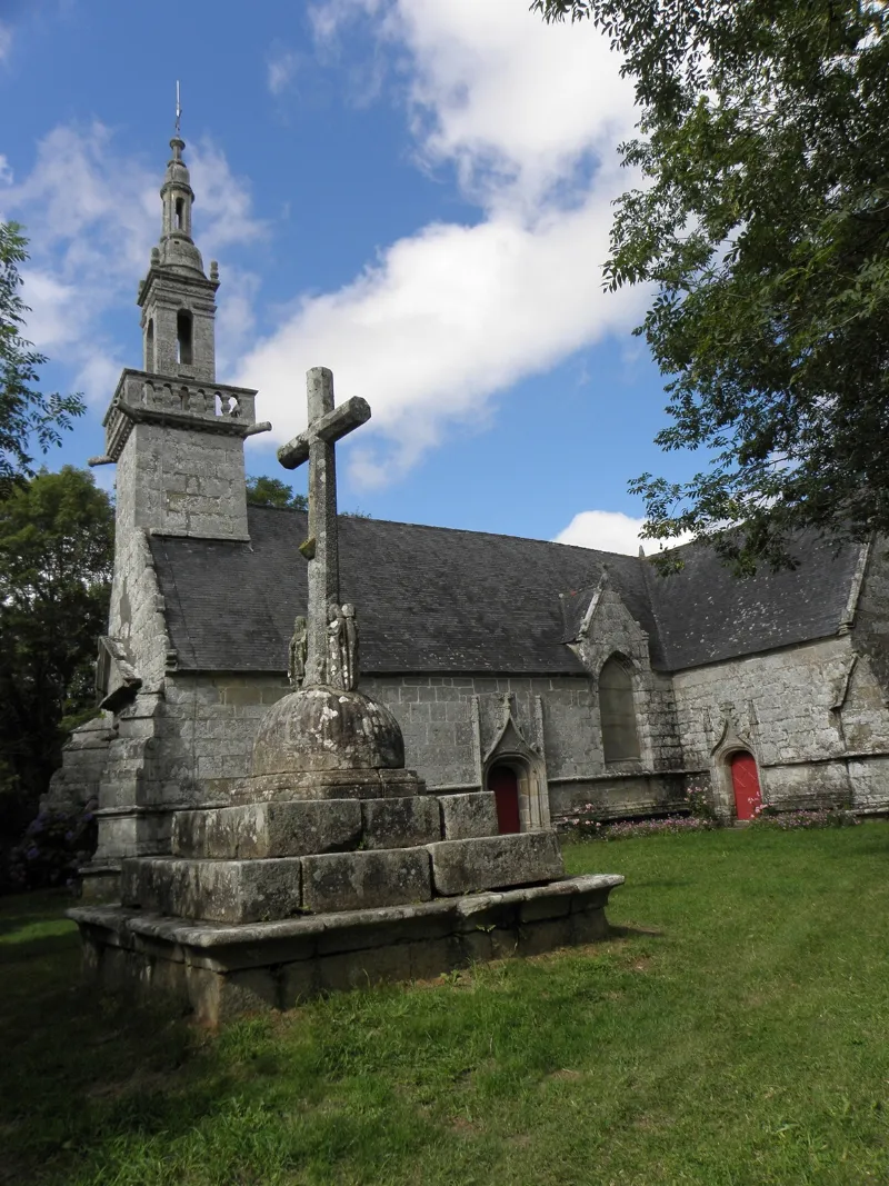
Saint-Pierre Chapel with its Calvary and Parish Close
No reviews yet
Have you flown here? Share your experience with other pilots.
+ Write the first reviewHistory
4e quart 16e siècle ; 17e siècle ; 18e siècle La chapelle se trouve au fond d'un vallon, à environ 2, 5 km du bourg de Plogonnec. On y accède par la route de ce bourg au Juch. C'est un bel édifice très régulier du 16e siècle, en forme de croix latine, tout entier en magnifiques pierres de taille. Le clocher, en forme de lanternon à trois dômes, appartient au genre Renaissance et est d'une décoration assez soignée. Il est accompagné d'une tourelle dégagée, qu'une passerelle relie à la plate-forme, aux angles de laquelle apparaissent de canons de granit. La porte à fronton triangulaire est accostée de deux colonnes ioniques cannelées, ayant un tambour feuillagé qui repose sur une base carrée. La chapelle est particulièrement riche en inscriptions précises. Succédant à un sanctuaire tombé en ruines (à proximité subsiste la maison du chapelain avec porte à accolade, ayant la date de 1570) se trouve l'édifice, dont la construction, commencée en 1588, s'est poursuivie aux diverses dates attestées par les inscriptions. L'essentiel est de la fin du 16e siècle et du début du siècle suivant, certains compléments ou restaurations datant de 1674 (façade nord, sacristie) et de 1759-1765 (tourelle et dôme). Le maître-autel, du 18e siècle, est en granit. Il est décoré de frises d'oves coupées de têtes humaines, d'angelots portant des bouquets fleuris et de deux gracieuses figures féminines, l'une blonde, l'autre brune, à la poitrine bien accentuée, élégamment drapées à la juive, la tête couverte d'un voile, et balançant des encensoirs de bois. L'ensemble des sablières est entièrement sculpté et les sabots apparents de la charpente de la croisée de transept représentent les quatre Evangélistes. Cet ensemble est assez unique dans la région.
Map and restricted areas
Open in the main mapRestricted zones
Nearby aerodromes
Open aerodromes within 25 km of the spot, heliports included, with their distance and direction from the spot. Near an aerodrome, drone flying is prohibited or height-limited: check the UAS zones map.
| Aerodrome | Type | Distance | Elevation |
|---|---|---|---|
| Quimper-Cornouaille Airport | Airport | 12 km S | 91 m |
| Cornouailles Heliport | Heliport | 14 km SE | 54 m |
Aviation weather (METAR and TAF)
LFRQ – Quimper-Cornouaille Airport MVFR
METAR
METAR LFRQ 171330Z AUTO 22020G32KT 9000 BKN019 BKN029 OVC096 15/12 Q0989 TEMPO 24025G50KT 1400 TSRAGS BKN006 BKN020CB
- Wind
- 220°, 37 km/h, gusts 59 km/h
- Visibility
- 9 km
- Clouds
- Broken (5-7/8) at 1,900 ft (580 m) ; Broken (5-7/8) at 2,900 ft (880 m) ; Overcast (8/8) at 9,600 ft (2930 m)
- Temperature
- 15 °C, dew point 12 °C
- QNH
- 989 hPa
- Flight category
- MVFR: ceiling 1,000–3,000 ft or visibility 3–5 mi
TAF
TAF LFRQ 171100Z 1712/1812 24020G30KT 9999 BKN020 TEMPO 1712/1812 25020G40KT 3000 SHRA BKN012 SCT020CB SCT025TCU PROB40 TEMPO 1712/1716 24025G50KT 1400 TSRAGS BKN006 BKN020CB PROB40 TEMPO 1800/1808 1400 TSRA
| Period (local time) | Change | Wind | Visibility | Weather | Clouds |
|---|---|---|---|---|---|
| 17/11 13:00 → 18/11 13:00 | Initial conditions | 240°, 37 km/h, gusts 56 km/h | 10 km or more | Broken (5-7/8) at 2,000 ft (610 m) | |
| 17/11 13:00 → 18/11 13:00 | Temporarily | 250°, 37 km/h, gusts 74 km/h | 3.0 km | Showers of rain | Broken (5-7/8) at 1,200 ft (370 m) ; Scattered (3-4/8) at 2,000 ft (610 m) (cumulonimbus) ; Scattered (3-4/8) at 2,500 ft (760 m) (towering cumulus) |
| 17/11 13:00 → 17/11 17:00 | Temporarily, probability 40% | 240°, 46 km/h, gusts 93 km/h | 1.4 km | Thunderstorm rain ; thunderstorm small hail | Broken (5-7/8) at 600 ft (180 m) ; Broken (5-7/8) at 2,000 ft (610 m) (cumulonimbus) |
| 18/11 01:00 → 18/11 09:00 | Temporarily, probability 40% | 1.4 km | Thunderstorm rain |
Weather and Kp index
| Day | Weather | Temp. min. / max. | Wind | Rain | Max Kp |
|---|---|---|---|---|---|
| Tue 17 Nov | Heavy rain | 12° / 12° | 42 km/h SW | 4.7 mm | 5 |
| Wed 18 Nov | Fair | 9° / 14° | 37 km/h W | 11 mm | 5 |
| Thu 19 Nov | Showers | 10° / 12° | 44 km/h W | 12 mm | 3 |
| Fri 20 Nov | Fair | 10° / 13° | 40 km/h W | 4.5 mm | 3 |
| Sat 21 Nov | Partly cloudy | 9° / 14° | 29 km/h SE | 9.2 mm | – |
| Sun 22 Nov | Light rain | 10° / 12° | 40 km/h W | 12 mm | – |
| Mon 23 Nov | Showers | 8° / 13° | 20 km/h S | 12 mm | – |
Hour by hour: Tuesday 17 November
| Time | Weather | Temp. | Wind | Rain | Clouds | Kp |
|---|---|---|---|---|---|---|
| 15:00 | Heavy rain | 12° | 42 km/h SW | 3.0 mm | 100 % | 4 |
| 16:00 | Rain | 12° | 37 km/h SW | 0.7 mm | 90 % | 4 |
| 17:00 | Fair | 12° | 36 km/h W | – | 30 % | 4 |
| 18:00 | Fair | 12° | 34 km/h W | – | 23 % | 4 |
| 19:00 | Fair | 12° | 32 km/h W | – | 14 % | 5 |
| 20:00 | Fair | 12° | 32 km/h W | – | 27 % | 5 |
| 21:00 | Showers | 12° | 34 km/h SW | 0.7 mm | 34 % | 5 |
| 22:00 | Showers | 12° | 37 km/h W | 0.2 mm | 33 % | 5 |
Hour by hour: Wednesday 18 November
| Time | Weather | Temp. | Wind | Rain | Clouds | Kp |
|---|---|---|---|---|---|---|
| 06:00 | Light rain | 10° | 33 km/h W | 0.3 mm | 93 % | 4 |
| 07:00 | Showers | 11° | 32 km/h W | 0.2 mm | 67 % | 4 |
| 08:00 | Partly cloudy | 11° | 33 km/h W | – | 49 % | 4 |
| 09:00 | Clear sky | 12° | 32 km/h W | – | 6 % | 4 |
| 10:00 | Fair | 12° | 33 km/h W | – | 23 % | 4 |
| 11:00 | Clear sky | 13° | 31 km/h SW | – | 1 % | 4 |
| 12:00 | Fair | 14° | 28 km/h SW | – | 18 % | 4 |
| 13:00 | Fair | 14° | 31 km/h SW | – | 24 % | 3 |
| 14:00 | Light rain | 14° | 30 km/h SW | 0.3 mm | 99 % | 3 |
| 15:00 | Rain | 13° | 31 km/h SW | 0.7 mm | 99 % | 3 |
| 16:00 | Heavy rain | 12° | 29 km/h SW | 1.0 mm | 100 % | 3 |
| 17:00 | Heavy rain | 11° | 33 km/h SW | 1.5 mm | 100 % | 3 |
| 18:00 | Rain | 11° | 35 km/h SW | 0.6 mm | 100 % | 3 |
| 19:00 | Showers | 12° | 33 km/h SW | 0.1 mm | 48 % | 2 |
| 20:00 | Showers | 11° | 34 km/h SW | 0.8 mm | 60 % | 2 |
| 21:00 | Showers | 10° | 37 km/h W | 0.2 mm | 75 % | 2 |
| 22:00 | Showers | 10° | 33 km/h SW | 0.4 mm | 63 % | 2 |
Sunrise and sunset
| Day | Dawn | Sunrise | Golden hour | Sunset | Dusk | Day length |
|---|---|---|---|---|---|---|
| Tue 17 Nov | 07:52 | 08:27 | 08:27–09:15 · 16:48–17:37 | 17:37 | 18:11 | 9 h 10 |
| Wed 18 Nov | 07:54 | 08:28 | 08:28–09:17 · 16:47–17:36 | 17:36 | 18:10 | 9 h 08 |
| Thu 19 Nov | 07:55 | 08:29 | 08:29–09:19 · 16:46–17:35 | 17:35 | 18:09 | 9 h 05 |
| Fri 20 Nov | 07:57 | 08:31 | 08:31–09:20 · 16:45–17:34 | 17:34 | 18:08 | 9 h 03 |
| Sat 21 Nov | 07:58 | 08:32 | 08:32–09:22 · 16:43–17:33 | 17:33 | 18:08 | 9 h 00 |
| Sun 22 Nov | 07:59 | 08:34 | 08:34–09:24 · 16:42–17:32 | 17:32 | 18:07 | 8 h 58 |
| Mon 23 Nov | 08:01 | 08:35 | 08:35–09:25 · 16:41–17:31 | 17:31 | 18:06 | 8 h 56 |
Reviews (0)
Log in to review this spot. Log in · Create a free account
No reviews yet. Share yours!