

Tourist site
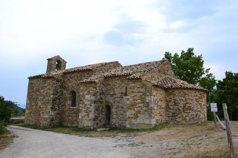
Church or Former Temple
No reviews yet
Have you flown here? Share your experience with other pilots.
+ Write the first reviewHistory
12e siècle
Map and restricted areas
Open in the main mapRestricted zones
| Zone | Category | Limits | Conditions |
|---|---|---|---|
| SETBA Secteur DRÔME | Entrainement Militaire | 0 m above ground level → 15241 m above ground level | Pilotage de drones en vue directe : les aéronefs dont la masse est supérieure à 900 grammes sont soumis à notification préalable selon des modalités publiées sur le site www.ecologie.gouv.fr |
| Zrt Privas High | ZRT | FL 175 / FL 185 | SUP AIP 055/26 · Du jeudi 16 avril 2026 au mercredi 12 avril 2028 |
| Zrt Maquis 2 | ZRT | 1000 ft ASFC / FL 075 | SUP AIP 207/26 · Du lundi 28 septembre au vendredi 16 octobre 2026 |
Nearby aerodromes
Open aerodromes within 25 km of the spot, heliports included, with their distance and direction from the spot. Near an aerodrome, drone flying is prohibited or height-limited: check the UAS zones map.
| Aerodrome | Type | Distance | Elevation |
|---|---|---|---|
| LF2621 - Altisurface de Faucon | Aerodrome | 12 km E | 1,006 m |
| Aérodrome d'Aubenasson | Aerodrome | 15 km N | 247 m |
| Altiport de La Motte Chalancon | Aerodrome | 20 km E | 880 m |
| Clinique Pneumologique des rieux Heliport | Heliport | 23 km S | 315 m |
Aviation weather (METAR and TAF)
LFLU – Valence-Chabeuil Airport VFR
METAR
METAR LFLU 171330Z AUTO 20010KT 9999 FEW056 BKN150 OVC190 13/11 Q1003
- Wind
- 200°, 19 km/h
- Visibility
- 10 km or more
- Clouds
- Few (1-2/8) at 5,600 ft (1710 m) ; Broken (5-7/8) at 15,000 ft (4570 m) ; Overcast (8/8) at 19,000 ft (5790 m)
- Temperature
- 13 °C, dew point 11 °C
- QNH
- 1003 hPa
- Flight category
- VFR: ceiling > 3,000 ft and visibility > 5 mi
TAF
Weather and Kp index
| Day | Weather | Temp. min. / max. | Wind | Rain | Max Kp |
|---|---|---|---|---|---|
| Tue 17 Nov | Cloudy | 11° / 12° | 17 km/h S | 3.2 mm | 5 |
| Wed 18 Nov | Fair | 9° / 15° | 15 km/h S | 2.9 mm | 5 |
| Thu 19 Nov | Showers | 7° / 13° | 14 km/h SE | 9.6 mm | 3 |
| Fri 20 Nov | Showers | 7° / 11° | 13 km/h S | 1.6 mm | 3 |
| Sat 21 Nov | Clear sky | 6° / 13° | 8 km/h N | – | – |
| Sun 22 Nov | Showers | 8° / 14° | 10 km/h SE | 17 mm | – |
| Mon 23 Nov | Partly cloudy | 6° / 11° | 12 km/h NW | 0.1 mm | – |
Hour by hour: Tuesday 17 November
| Time | Weather | Temp. | Wind | Rain | Clouds | Kp |
|---|---|---|---|---|---|---|
| 15:00 | Cloudy | 12° | 9 km/h SE | – | 100 % | 4 |
| 16:00 | Cloudy | 12° | 9 km/h SE | – | 100 % | 4 |
| 17:00 | Cloudy | 12° | 14 km/h S | – | 100 % | 4 |
| 18:00 | Rain | 12° | 13 km/h S | 0.9 mm | 100 % | 4 |
| 19:00 | Rain | 11° | 16 km/h S | 0.5 mm | 100 % | 5 |
| 20:00 | Light rain | 11° | 15 km/h S | 0.2 mm | 100 % | 5 |
| 21:00 | Light rain | 11° | 16 km/h S | 0.1 mm | 100 % | 5 |
| 22:00 | Light rain | 11° | 17 km/h S | 0.1 mm | 95 % | 5 |
Hour by hour: Wednesday 18 November
| Time | Weather | Temp. | Wind | Rain | Clouds | Kp |
|---|---|---|---|---|---|---|
| 06:00 | Partly cloudy | 10° | 12 km/h S | – | 78 % | 4 |
| 07:00 | Partly cloudy | 10° | 12 km/h S | – | 56 % | 4 |
| 08:00 | Partly cloudy | 10° | 13 km/h S | – | 49 % | 4 |
| 09:00 | Partly cloudy | 11° | 12 km/h S | – | 44 % | 4 |
| 10:00 | Partly cloudy | 12° | 12 km/h S | – | 48 % | 4 |
| 11:00 | Fair | 14° | 13 km/h SW | – | 28 % | 4 |
| 12:00 | Fair | 15° | 12 km/h SW | – | 14 % | 4 |
| 13:00 | Fair | 15° | 11 km/h W | – | 14 % | 3 |
| 14:00 | Clear sky | 15° | 13 km/h W | – | 12 % | 3 |
| 15:00 | Showers | 15° | 13 km/h W | 0.1 mm | 24 % | 3 |
| 16:00 | Showers | 14° | 11 km/h SW | 0.1 mm | 60 % | 3 |
| 17:00 | Partly cloudy | 11° | 7 km/h SE | – | 51 % | 3 |
| 18:00 | Fair | 10° | 9 km/h S | – | 30 % | 3 |
| 19:00 | Partly cloudy | 10° | 8 km/h S | – | 84 % | 2 |
| 20:00 | Partly cloudy | 10° | 10 km/h S | – | 97 % | 2 |
| 21:00 | Partly cloudy | 9° | 10 km/h S | – | 98 % | 2 |
| 22:00 | Cloudy | 10° | 12 km/h SE | – | 98 % | 2 |
Sunrise and sunset
| Day | Dawn | Sunrise | Golden hour | Sunset | Dusk | Day length |
|---|---|---|---|---|---|---|
| Tue 17 Nov | 07:07 | 07:38 | 07:38–08:23 · 16:26–17:10 | 17:10 | 17:42 | 9 h 31 |
| Wed 18 Nov | 07:08 | 07:40 | 07:40–08:25 · 16:24–17:09 | 17:09 | 17:41 | 9 h 29 |
| Thu 19 Nov | 07:09 | 07:41 | 07:41–08:26 · 16:23–17:08 | 17:08 | 17:40 | 9 h 27 |
| Fri 20 Nov | 07:11 | 07:42 | 07:42–08:27 · 16:22–17:08 | 17:08 | 17:39 | 9 h 25 |
| Sat 21 Nov | 07:12 | 07:44 | 07:44–08:29 · 16:21–17:07 | 17:07 | 17:39 | 9 h 23 |
| Sun 22 Nov | 07:13 | 07:45 | 07:45–08:30 · 16:21–17:06 | 17:06 | 17:38 | 9 h 21 |
| Mon 23 Nov | 07:14 | 07:46 | 07:46–08:32 · 16:20–17:05 | 17:05 | 17:37 | 9 h 19 |

Reviews (0)
Log in to review this spot. Log in · Create a free account
No reviews yet. Share yours!