

Combe à la Serpent Apiary
No reviews yet
Have you flown here? Share your experience with other pilots.
+ Write the first reviewHistory
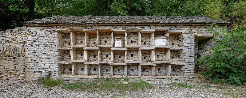
19e siècle L'emplacement du rucher n'apparaît avec certitude qu'en 1812, sur le plan cadastral napoléonien. L'origine de propriété remonte au 19e siècle. Le rucher a été construit selon les méthodes traditionnelles locales : moellons et laves extraits de carrières proches, sur une terrasse. Il est formé d'un corps de bâtiment oblong, couvert d'un toit à un versant, en laves, lequel se divise en deux parties. La première abrite, sur trois niveaux, neuf cases en pierres s'appuyant sur un mur. Un couloir, parallèle à ce mur, dessert à l'intérieur du bâtiment le même nombre de cases. L'accès à ce couloir s'effectue par une porte couverte d'un linteau monolithe, percée à droite des cases extérieures. La porte est fermée par une grille métallique. La seconde partie, autrefois couverte, formait un abri et un laboratoire pour l'apiculteur
Map and restricted areas
Open in the main mapRestricted zones
Nearby aerodromes
Open aerodromes within 25 km of the spot, heliports included, with their distance and direction from the spot. Near an aerodrome, drone flying is prohibited or height-limited: check the UAS zones map.
| Aerodrome | Type | Distance | Elevation |
|---|---|---|---|
| Centre Hospitalier Régional Heliport | Heliport | 5.2 km E | 238 m |
| Dijon Darois Airfield | Aerodrome | 8.5 km N | 483 m |
| Dijon-Bourgogne Airport | Airport | 11 km SE | 221 m |
| Aérodrome de Nuits-Saint-Georges | Aerodrome | 19 km S | 243 m |
Aviation weather (METAR and TAF)
LFSD – Dijon-Bourgogne Airport VFR
METAR
METAR LFSD 171330Z AUTO 23014KT 9999 SCT039 BKN045 BKN055 18/11 Q0998
- Wind
- 230°, 26 km/h
- Visibility
- 10 km or more
- Clouds
- Scattered (3-4/8) at 3,900 ft (1190 m) ; Broken (5-7/8) at 4,500 ft (1370 m) ; Broken (5-7/8) at 5,500 ft (1680 m)
- Temperature
- 18 °C, dew point 11 °C
- QNH
- 998 hPa
- Flight category
- VFR: ceiling > 3,000 ft and visibility > 5 mi
TAF
Weather and Kp index
| Day | Weather | Temp. min. / max. | Wind | Rain | Max Kp |
|---|---|---|---|---|---|
| Tue 17 Nov | Partly cloudy | 10° / 15° | 29 km/h SW | 2.1 mm | 5 |
| Wed 18 Nov | Showers | 8° / 12° | 30 km/h W | 1.1 mm | 5 |
| Thu 19 Nov | Showers | 8° / 11° | 30 km/h SW | 11 mm | 3 |
| Fri 20 Nov | Showers | 8° / 11° | 25 km/h SW | 2.2 mm | 3 |
| Sat 21 Nov | Partly cloudy | 6° / 11° | 18 km/h SW | 0.2 mm | – |
| Sun 22 Nov | Fair | 4° / 10° | 21 km/h SW | 9.3 mm | – |
| Mon 23 Nov | Fair | 6° / 10° | 21 km/h SW | 0.5 mm | – |
Hour by hour: Tuesday 17 November
| Time | Weather | Temp. | Wind | Rain | Clouds | Kp |
|---|---|---|---|---|---|---|
| 15:00 | Partly cloudy | 15° | 26 km/h SW | – | 66 % | 4 |
| 16:00 | Partly cloudy | 14° | 22 km/h SW | – | 59 % | 4 |
| 17:00 | Partly cloudy | 13° | 23 km/h SW | – | 70 % | 4 |
| 18:00 | Fair | 13° | 24 km/h SW | – | 27 % | 4 |
| 19:00 | Fair | 13° | 26 km/h SW | – | 31 % | 5 |
| 20:00 | Partly cloudy | 12° | 27 km/h SW | – | 47 % | 5 |
| 21:00 | Heavy rain | 12° | 27 km/h SW | 1.3 mm | 99 % | 5 |
| 22:00 | Rain | 10° | 29 km/h SW | 0.4 mm | 100 % | 5 |
Hour by hour: Wednesday 18 November
| Time | Weather | Temp. | Wind | Rain | Clouds | Kp |
|---|---|---|---|---|---|---|
| 06:00 | Cloudy | 10° | 23 km/h SW | – | 91 % | 4 |
| 07:00 | Partly cloudy | 10° | 23 km/h SW | – | 66 % | 4 |
| 08:00 | Partly cloudy | 9° | 23 km/h SW | – | 59 % | 4 |
| 09:00 | Cloudy | 10° | 26 km/h SW | – | 98 % | 4 |
| 10:00 | Showers | 11° | 26 km/h SW | 0.2 mm | 70 % | 4 |
| 11:00 | Showers | 11° | 28 km/h SW | 0.2 mm | 36 % | 4 |
| 12:00 | Showers | 12° | 30 km/h W | 0.2 mm | 52 % | 4 |
| 13:00 | Showers | 12° | 30 km/h W | 0.2 mm | 73 % | 3 |
| 14:00 | Showers | 12° | 28 km/h W | 0.1 mm | 48 % | 3 |
| 15:00 | Fair | 12° | 28 km/h SW | – | 15 % | 3 |
| 16:00 | Fair | 12° | 26 km/h SW | – | 27 % | 3 |
| 17:00 | Clear sky | 11° | 22 km/h SW | – | 11 % | 3 |
| 18:00 | Fair | 10° | 20 km/h SW | – | 37 % | 3 |
| 19:00 | Partly cloudy | 10° | 20 km/h SW | – | 52 % | 2 |
| 20:00 | Partly cloudy | 9° | 18 km/h SW | – | 66 % | 2 |
| 21:00 | Cloudy | 9° | 16 km/h S | – | 94 % | 2 |
| 22:00 | Cloudy | 8° | 17 km/h S | – | 100 % | 2 |
Sunrise and sunset
| Day | Dawn | Sunrise | Golden hour | Sunset | Dusk | Day length |
|---|---|---|---|---|---|---|
| Tue 17 Nov | 07:14 | 07:47 | 07:47–08:35 · 16:15–17:03 | 17:03 | 17:36 | 9 h 15 |
| Wed 18 Nov | 07:15 | 07:49 | 07:49–08:37 · 16:14–17:02 | 17:02 | 17:35 | 9 h 13 |
| Thu 19 Nov | 07:17 | 07:50 | 07:50–08:38 · 16:13–17:01 | 17:01 | 17:35 | 9 h 10 |
| Fri 20 Nov | 07:18 | 07:52 | 07:52–08:40 · 16:11–17:00 | 17:00 | 17:34 | 9 h 08 |
| Sat 21 Nov | 07:19 | 07:53 | 07:53–08:42 · 16:10–16:59 | 16:59 | 17:33 | 9 h 05 |
| Sun 22 Nov | 07:20 | 07:54 | 07:54–08:43 · 16:09–16:58 | 16:58 | 17:32 | 9 h 03 |
| Mon 23 Nov | 07:22 | 07:56 | 07:56–08:45 · 16:08–16:57 | 16:57 | 17:31 | 9 h 01 |


Reviews (0)
Log in to review this spot. Log in · Create a free account
No reviews yet. Share yours!