

Ruins of the Mortella Tower
No reviews yet
Have you flown here? Share your experience with other pilots.
+ Write the first reviewHistory
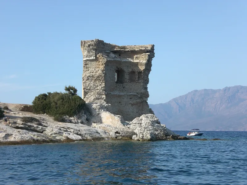
1ère moitié 16e siècle Tour édifiée en 1553 et fortifiée en 1554, pendant la guerre de Corse, par l'amiral Andrea Doria. Cette tour est la seule de l'ensemble du littoral des Agriates existant, non seulement de nos jours mais également aux 17e et 18e siècles. En raison de son importance stratégique (face à l'entrée du golfe de Saint-Florent) , les autorités génoises lui attribuèrent une garnison tournante payée par la Camera. Elle assurait également le rôle de poste de douane. Dans la seconde moitié du 18e siècle, une série d'évènements sont à l'origine de sa destruction. En 1760, Pascal Paoli fit tirer sur la tour. En 1793, les Anglais s'en emparèrent. En 1794, reprise par les Français, la tour fut à nouveau attaquée par les Anglais qui s'en emparèrent. L'amiral Nelson aurait demandé à son état major d'en relever les plans comme modèle pour la construction de tours sur les côtes de Grande-Bretagne et d'Irlande.£Actuellement à demi ruinée, la tour circulaire comprenait trois niveaux et une terrasse couronnée de mâchicoulis. Le premier niveau contenait une citerne. L'escalier intérieur qui permettait de passer d'un étage à l'autre, a disparu. Au-dessus du cordon, le mur est construit selon une pente extérieure de 13° reprise, côté intérieur, d'une manière parallèle. Cette pente intérieure correspond à la voûte qui coiffait le premier niveau.
Map and restricted areas
Open in the main mapRestricted zones
Nearby aerodromes
Open aerodromes within 25 km of the spot, heliports included, with their distance and direction from the spot. Near an aerodrome, drone flying is prohibited or height-limited: check the UAS zones map.
No known open aerodrome within 25 km.
Aviation weather (METAR and TAF)
LFKB – Bastia-Poretta Airport VFR
METAR
METAR LFKB 171330Z AUTO 12004KT 090V150 9999 FEW076 SCT100 20/15 Q1005 TEMPO 21015G30KT
- Wind
- 120°, 7 km/h
- Visibility
- 10 km or more
- Clouds
- Few (1-2/8) at 7,600 ft (2320 m) ; Scattered (3-4/8) at 10,000 ft (3050 m)
- Temperature
- 20 °C, dew point 15 °C
- QNH
- 1005 hPa
- Flight category
- VFR: ceiling > 3,000 ft and visibility > 5 mi
TAF
TAF LFKB 170800Z 1709/1809 VRB02KT CAVOK TX21/1713Z TN13/1709Z BECMG 1711/1713 24014KT TEMPO 1714/1806 21015G30KT PROB40 TEMPO 1720/1722 33015G30KT
| Period (local time) | Change | Wind | Visibility | Weather | Clouds |
|---|---|---|---|---|---|
| 17/11 10:00 → 17/11 12:00 | Initial conditions | Variable, 4 km/h | 10 km or more | No significant cloud | |
| 17/11 12:00 → 18/11 10:00 | Becoming | 240°, 26 km/h | 10 km or more | No significant cloud | |
| 17/11 15:00 → 18/11 07:00 | Temporarily | 210°, 28 km/h, gusts 56 km/h | |||
| 17/11 21:00 → 17/11 23:00 | Temporarily, probability 40% | 330°, 28 km/h, gusts 56 km/h |
Weather and Kp index
Sunrise and sunset
| Day | Dawn | Sunrise | Golden hour | Sunset | Dusk | Day length |
|---|---|---|---|---|---|---|
| Tue 17 Nov | 06:47 | 07:17 | 07:17–08:00 · 16:16–16:59 | 16:59 | 17:29 | 9 h 41 |
| Wed 18 Nov | 06:48 | 07:18 | 07:18–08:01 · 16:15–16:58 | 16:58 | 17:28 | 9 h 39 |
| Thu 19 Nov | 06:49 | 07:20 | 07:20–08:03 · 16:14–16:57 | 16:57 | 17:28 | 9 h 37 |
| Fri 20 Nov | 06:50 | 07:21 | 07:21–08:04 · 16:13–16:56 | 16:56 | 17:27 | 9 h 35 |
| Sat 21 Nov | 06:51 | 07:22 | 07:22–08:05 · 16:12–16:56 | 16:56 | 17:26 | 9 h 33 |
| Sun 22 Nov | 06:52 | 07:23 | 07:23–08:07 · 16:11–16:55 | 16:55 | 17:26 | 9 h 31 |
| Mon 23 Nov | 06:54 | 07:24 | 07:24–08:08 · 16:11–16:54 | 16:54 | 17:25 | 9 h 29 |
Reviews (0)
Log in to review this spot. Log in · Create a free account
No reviews yet. Share yours!