

Pitray Castle
No reviews yet
Have you flown here? Share your experience with other pilots.
+ Write the first reviewHistory
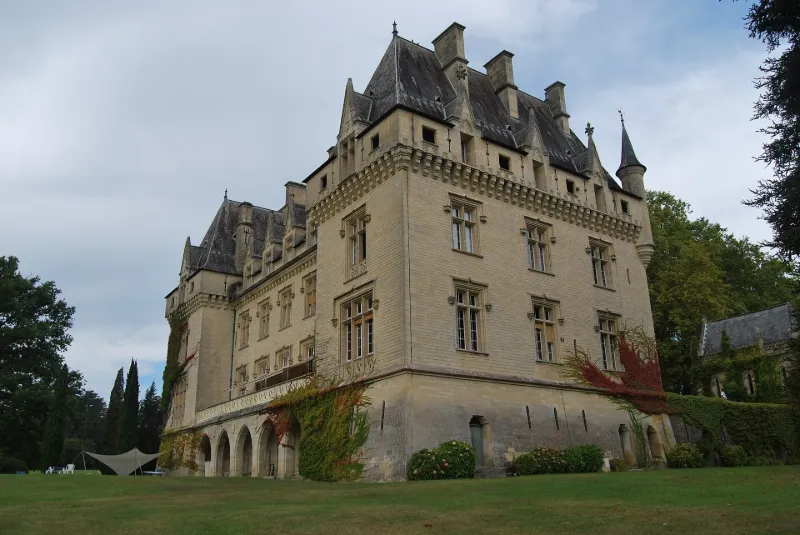
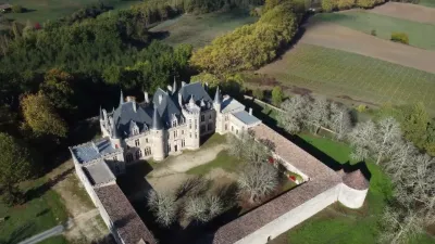
3e quart 19e siècle Le château actuel a été entièrement reconstruit vers 1870 à l'emplacement d'un château du 14e siècle, remanié au 16e. Les allées conduisant au château débouchent sur la terrasse nord, ancienne cour intérieure des communs, à l'angle de laquelle a été construite la chapelle dans un style néo-gothique. Sur l'élévation nord, une partie centrale est encadrée de chaque côté d'une tour pentagonale, elle-même flanquée d'un pavillon rectangulaire en saillie. L'élévation sud reprend la même disposition, à l'exception des tours. Quelques décors intérieurs ont été préservés. Des communs se développent à l'est du château, sous forme de deux bâtiments rectangulaires séparés par une cour. Un pigeonnier circulaire s'élève dans l'angle. Des écuries ont été construites au nord. Au nord du château se déploient les activités traditionnelles et viticoles autour desquelles s'organisent allées et carrefours. A l'est, une perspective naturaliste dans le vallon plongeant vers le sud, compose un grand parc paysager.
Map and restricted areas
Open in the main mapRestricted zones
| Zone | Category | Limits | Conditions |
|---|---|---|---|
| Gironde Sud | Zone réglementée | 244 m above ground level → 762 m above sea level | Vols interdits sauf lorsque the official document of the zone l'autorise explicitement ou avec l'accord du gestionnaire de la zone lorsqu'il est désigné par the official document of the zone |
Nearby aerodromes
Open aerodromes within 25 km of the spot, heliports included, with their distance and direction from the spot. Near an aerodrome, drone flying is prohibited or height-limited: check the UAS zones map.
| Aerodrome | Type | Distance | Elevation |
|---|---|---|---|
| Libourne-Artigues-de-Lussac Airport | Airport | 12 km NW | 48 m |
| Aérodrome de Sainte-Foy-la-Grande | Aerodrome | 17 km E | 86 m |
Aviation weather (METAR and TAF)
LFBE – Bergerac-Roumanière Airport VFR
METAR
METAR LFBE 171400Z AUTO 20009KT 170V230 9999 -RA FEW020/// OVC094/// ///CB 17/14 Q1002 TEMPO 24015G25KT 4000 SHRA
- Wind
- 200°, 17 km/h
- Visibility
- 10 km or more
- Weather
- Rain light
- Clouds
- Few (1-2/8) at 2,000 ft (610 m) ; Overcast (8/8) at 9,400 ft (2870 m)
- Temperature
- 17 °C, dew point 14 °C
- QNH
- 1002 hPa
- Flight category
- VFR: ceiling > 3,000 ft and visibility > 5 mi
TAF
TAF LFBE 171100Z 1712/1812 24010KT 9999 BKN020 TEMPO 1712/1714 24015G25KT 3000 RA OVC010 PROB30 TEMPO 1714/1720 24015G25KT 4000 SHRA BKN020TCU TEMPO 1720/1812 24015G25KT 3500 SHRA BKN010 BKN040TCU PROB30 TEMPO 1722/1802 24020G35KT 2000 TSRA BKN008 BKN020CB
| Period (local time) | Change | Wind | Visibility | Weather | Clouds |
|---|---|---|---|---|---|
| 17/11 13:00 → 18/11 13:00 | Initial conditions | 240°, 19 km/h | 10 km or more | Broken (5-7/8) at 2,000 ft (610 m) | |
| 17/11 13:00 → 17/11 15:00 | Temporarily | 240°, 28 km/h, gusts 46 km/h | 3.0 km | Rain | Overcast (8/8) at 1,000 ft (300 m) |
| 17/11 15:00 → 17/11 21:00 | Temporarily, probability 30% | 240°, 28 km/h, gusts 46 km/h | 4.0 km | Showers of rain | Broken (5-7/8) at 2,000 ft (610 m) (towering cumulus) |
| 17/11 21:00 → 18/11 13:00 | Temporarily | 240°, 28 km/h, gusts 46 km/h | 3.5 km | Showers of rain | Broken (5-7/8) at 1,000 ft (300 m) ; Broken (5-7/8) at 4,000 ft (1220 m) (towering cumulus) |
| 17/11 23:00 → 18/11 03:00 | Temporarily, probability 30% | 240°, 37 km/h, gusts 65 km/h | 2.0 km | Thunderstorm rain | Broken (5-7/8) at 800 ft (240 m) ; Broken (5-7/8) at 2,000 ft (610 m) (cumulonimbus) |
Weather and Kp index
Sunrise and sunset
| Day | Dawn | Sunrise | Golden hour | Sunset | Dusk | Day length |
|---|---|---|---|---|---|---|
| Tue 17 Nov | 07:28 | 08:00 | 08:00–08:45 · 16:45–17:30 | 17:30 | 18:02 | 9 h 29 |
| Wed 18 Nov | 07:30 | 08:01 | 08:01–08:47 · 16:44–17:29 | 17:29 | 18:01 | 9 h 27 |
| Thu 19 Nov | 07:31 | 08:03 | 08:03–08:48 · 16:43–17:28 | 17:28 | 18:00 | 9 h 25 |
| Fri 20 Nov | 07:32 | 08:04 | 08:04–08:50 · 16:42–17:27 | 17:27 | 17:59 | 9 h 23 |
| Sat 21 Nov | 07:33 | 08:05 | 08:05–08:51 · 16:41–17:27 | 17:27 | 17:59 | 9 h 21 |
| Sun 22 Nov | 07:35 | 08:07 | 08:07–08:53 · 16:40–17:26 | 17:26 | 17:58 | 9 h 19 |
| Mon 23 Nov | 07:36 | 08:08 | 08:08–08:54 · 16:39–17:25 | 17:25 | 17:57 | 9 h 17 |

Reviews (0)
Log in to review this spot. Log in · Create a free account
No reviews yet. Share yours!