

Tourist site
Hydraulic Network
No reviews yet
Have you flown here? Share your experience with other pilots.
+ Write the first reviewHistory
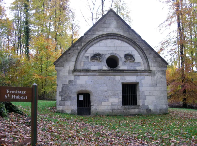
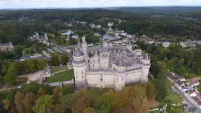
16e siècle Regard construit entre 1530-1540 sur l'ordre de François 1er, à l'emplacement d'un premier édifice médiéval. La façade est ornée des deux salamandres de François 1er. Les culots portant les arcs de la voûte sont ornés de têtes humaines fabuleuses. La réfection de l'édifice s'est accompagnée de celle du système d'adduction d'eau servant à alimenter le château.
Map and restricted areas
Open in the main mapRestricted zones
| Zone | Category | Limits | Conditions |
|---|---|---|---|
| Veille Region Parisienne | Zone réglementée | 0 m above ground level → 762 m above sea level | Vols interdits sauf lorsque the official document of the zone l'autorise explicitement ou avec l'accord du gestionnaire de la zone lorsqu'il est désigné par the official document of the zone |
| Paris 3 | Zone réglementée | 762 m above sea level → 1067 m above sea level | Vols interdits sauf lorsque the official document of the zone l'autorise explicitement ou avec l'accord du gestionnaire de la zone lorsqu'il est désigné par the official document of the zone |
| Paris 4 | Zone réglementée | 1067 m above sea level → 1372 m above sea level | Vols interdits sauf lorsque the official document of the zone l'autorise explicitement ou avec l'accord du gestionnaire de la zone lorsqu'il est désigné par the official document of the zone |
| Paris 5 | Zone réglementée | 1372 m above sea level → 2297 m above sea level | Vols interdits sauf lorsque the official document of the zone l'autorise explicitement ou avec l'accord du gestionnaire de la zone lorsqu'il est désigné par the official document of the zone |
| Paris 7 | Zone réglementée | 1529 m above sea level → 2907 m above sea level | Vols interdits sauf lorsque the official document of the zone l'autorise explicitement ou avec l'accord du gestionnaire de la zone lorsqu'il est désigné par the official document of the zone |
| Paris 9 | Zone réglementée | 2138 m above sea level → 3821 m above sea level | Vols interdits sauf lorsque the official document of the zone l'autorise explicitement ou avec l'accord du gestionnaire de la zone lorsqu'il est désigné par the official document of the zone |
| Paris 11 | Zone réglementée | 3053 m above sea level → 6259 m above sea level | Vols interdits sauf lorsque the official document of the zone l'autorise explicitement ou avec l'accord du gestionnaire de la zone lorsqu'il est désigné par the official document of the zone |
| Zrt Opal | ZRT | From about 14,950 m to about 16,750 m above sea level | SUP AIP 233/24 · Du 16 janvier 2025 au 13 janvier 2027 |
Nearby aerodromes
Open aerodromes within 25 km of the spot, heliports included, with their distance and direction from the spot. Near an aerodrome, drone flying is prohibited or height-limited: check the UAS zones map.
| Aerodrome | Type | Distance | Elevation |
|---|---|---|---|
| Base ULM de Taillefontaine | Aerodrome | 3.8 km NW | 145 m |
| Base ULM de Mosloy | Aerodrome | 12 km S | 138 m |
| Aérodrome de Soissons - Courmelles | Aerodrome | 16 km NE | 155 m |
| Centre Hospitalier Heliport | Heliport | 20 km NE | 52 m |
| Centre Hospitalier Heliport | Heliport | 25 km NW | 33 m |
Aviation weather (METAR and TAF)
No METAR station within 50 km.
Weather and Kp index
Sunrise and sunset
| Day | Dawn | Sunrise | Golden hour | Sunset | Dusk | Day length |
|---|---|---|---|---|---|---|
| Tue 17 Nov | 07:26 | 08:01 | 08:01–08:52 · 16:13–17:04 | 17:04 | 17:39 | 9 h 02 |
| Wed 18 Nov | 07:28 | 08:03 | 08:03–08:54 · 16:12–17:03 | 17:03 | 17:38 | 9 h 00 |
| Thu 19 Nov | 07:29 | 08:04 | 08:04–08:55 · 16:11–17:02 | 17:02 | 17:37 | 8 h 57 |
| Fri 20 Nov | 07:30 | 08:06 | 08:06–08:57 · 16:09–17:01 | 17:01 | 17:36 | 8 h 54 |
| Sat 21 Nov | 07:32 | 08:07 | 08:07–08:59 · 16:08–17:00 | 17:00 | 17:35 | 8 h 52 |
| Sun 22 Nov | 07:33 | 08:09 | 08:09–09:01 · 16:07–16:59 | 16:59 | 17:34 | 8 h 49 |
| Mon 23 Nov | 07:35 | 08:10 | 08:10–09:02 · 16:06–16:58 | 16:58 | 17:33 | 8 h 47 |
Reviews (0)
Log in to review this spot. Log in · Create a free account
No reviews yet. Share yours!