

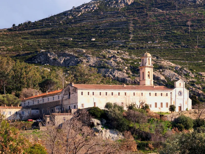
Saint-Dominique Convent
No reviews yet
Have you flown here? Share your experience with other pilots.
+ Write the first reviewHistory
15e siècle Le couvent, fondé en 1456, était l'ancien couvent Saint-François de la Pieve d'Aregno, devenu bien national à la Révolution puis vendu aux enchères. En 1857, les frères dominicains restaurent l'église et deux bâtiments en ruine. La reconstruction permet l'installation d'une école en 1857, qui ferme en 1860, ainsi qu'un collège de philosophie et de théologie. Inoccupé de 1905 à 1914, le couvent devient un centre d'internement de prisonniers civils allemands et autrichiens. £Eglise et bâtiments conventuels formés par quatre ailes, sont disposés autour du jardin de cloître de plan rectangulaire et s'ouvrent sur cet espace par des arcs plein cintre. L'église, adossée à l'aile sud, est formée d'une nef à vaisseau central et chapelles latérales voûtées en berceau à lunettes. Le choeur comprend une première travée droite, prolongée par une abside en cul de four. La tour clocher est sommée d'un lanternon couronné d'un dôme. Les bâtiments conventuels comprennent un rez-de-chaussée et un étage. Un étage de soubassement comprend caves et pressoir. £
Map and restricted areas
Open in the main mapRestricted zones
| Zone | Category | Limits | Conditions |
|---|---|---|---|
| Zit Ile Rousse | ZIT | From the ground up to about 150 m above the ground | SUP AIP 052/26 · Du jeudi 16 avril 2026 au mercredi 24 novembre 2027 |
| Zena Med | Zone dangereuse | 5491 m above sea level → 9003 m above sea level | Vols interdits sauf lorsque the official document of the zone l'autorise explicitement ou avec l'accord du gestionnaire de la zone lorsqu'il est désigné par the official document of the zone |
Nearby aerodromes
Open aerodromes within 25 km of the spot, heliports included, with their distance and direction from the spot. Near an aerodrome, drone flying is prohibited or height-limited: check the UAS zones map.
| Aerodrome | Type | Distance | Elevation |
|---|---|---|---|
| Calvi-Sainte-Catherine Airport | Airport | 13 km SW | 64 m |
Aviation weather (METAR and TAF)
LFKC – Calvi-Sainte-Catherine Airport VFR
METAR
METAR LFKC 171330Z AUTO 21027G38KT 180V240 9999 FEW046 21/13 Q1006 NOSIG
- Wind
- 210°, 50 km/h, gusts 70 km/h
- Visibility
- 10 km or more
- Clouds
- Few (1-2/8) at 4,600 ft (1400 m)
- Temperature
- 21 °C, dew point 13 °C
- QNH
- 1006 hPa
- Flight category
- VFR: ceiling > 3,000 ft and visibility > 5 mi
TAF
TAF LFKC 170800Z 1709/1809 21018G35KT CAVOK TX22/1713Z TN18/1803Z TEMPO 1709/1718 21025G40KT TEMPO 1716/1724 -SHRA SCT025TCU BECMG 1800/1802 21015G25KT
| Period (local time) | Change | Wind | Visibility | Weather | Clouds |
|---|---|---|---|---|---|
| 17/11 10:00 → 18/11 01:00 | Initial conditions | 210°, 33 km/h, gusts 65 km/h | 10 km or more | No significant cloud | |
| 17/11 10:00 → 17/11 19:00 | Temporarily | 210°, 46 km/h, gusts 74 km/h | |||
| 17/11 17:00 → 18/11 01:00 | Temporarily | Showers of rain light | Scattered (3-4/8) at 2,500 ft (760 m) (towering cumulus) | ||
| 18/11 01:00 → 18/11 10:00 | Becoming | 210°, 28 km/h, gusts 46 km/h | 10 km or more | No significant cloud |
Weather and Kp index
Sunrise and sunset
| Day | Dawn | Sunrise | Golden hour | Sunset | Dusk | Day length |
|---|---|---|---|---|---|---|
| Tue 17 Nov | 06:48 | 07:18 | 07:18–08:01 · 16:18–17:00 | 17:00 | 17:31 | 9 h 42 |
| Wed 18 Nov | 06:49 | 07:19 | 07:19–08:02 · 16:17–17:00 | 17:00 | 17:30 | 9 h 40 |
| Thu 19 Nov | 06:50 | 07:21 | 07:21–08:04 · 16:16–16:59 | 16:59 | 17:29 | 9 h 38 |
| Fri 20 Nov | 06:51 | 07:22 | 07:22–08:05 · 16:15–16:58 | 16:58 | 17:29 | 9 h 36 |
| Sat 21 Nov | 06:52 | 07:23 | 07:23–08:06 · 16:14–16:57 | 16:57 | 17:28 | 9 h 34 |
| Sun 22 Nov | 06:54 | 07:24 | 07:24–08:08 · 16:13–16:57 | 16:57 | 17:27 | 9 h 32 |
| Mon 23 Nov | 06:55 | 07:25 | 07:25–08:09 · 16:12–16:56 | 16:56 | 17:27 | 9 h 30 |
Reviews (0)
Log in to review this spot. Log in · Create a free account
No reviews yet. Share yours!