

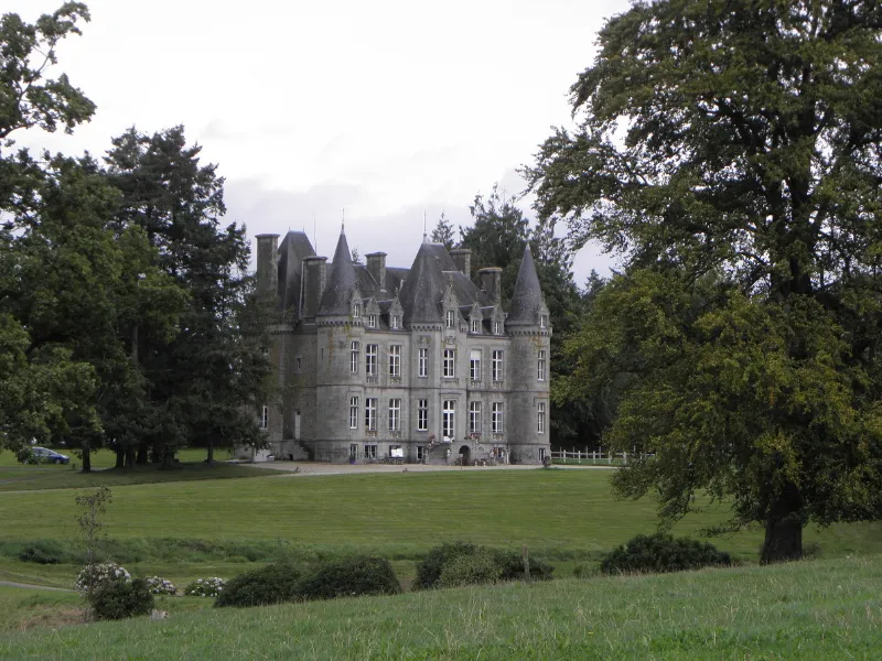
La Vieuville Castle
No reviews yet
Have you flown here? Share your experience with other pilots.
+ Write the first reviewHistory
16e siècle ; 18e siècle ; 19e siècle Le château se compose d'un logis, bâti en 1869, et de communs édifiés à la même époque. Une partie de l'ancien manoir, datant des 16ème et 17ème siècles, situé à proximité, est encore visible. L'ensemble s'intègre au sein d'un parc paysager réaménagé dans la seconde moitié du 19ème siècle. Le logis se présente comme un bâtiment de taille moyenne, à la composition symétrique, comprenant un corps central rectangulaire flanqué de tours circulaires. Son ornementation de style néo-classique est assez sobre. L'aménagement intérieur, bien conservé, se caractérise par un remploi d'éléments de l'ancien manoir.
Map and restricted areas
Open in the main mapRestricted zones
| Zone | Category | Limits | Conditions |
|---|---|---|---|
| SETBA Secteur SELUNE | Entrainement Militaire | 0 m above ground level → 15241 m above ground level | Pilotage de drones en vue directe : les aéronefs dont la masse est supérieure à 900 grammes sont soumis à notification préalable selon des modalités publiées sur le site www.ecologie.gouv.fr |
| Tours Cinq Mars la Pile | Zone réglementée | 3053 m above sea level → 6259 m above sea level | Vols interdits sauf lorsque the official document of the zone l'autorise explicitement ou avec l'accord du gestionnaire de la zone lorsqu'il est désigné par the official document of the zone |
| Zrt Fougeres | ZRT | From about 3,800 m to about 4,100 m above sea level | SUP AIP 053/26 · Du jeudi 16 avril 2026 au mercredi 12 avril 2028 |
| Zrt Fougeres High | ZRT | From about 6,250 m to about 6,550 m above sea level | SUP AIP 053/26 · Du jeudi 16 avril 2026 au mercredi 12 avril 2028 |
Nearby aerodromes
Open aerodromes within 25 km of the spot, heliports included, with their distance and direction from the spot. Near an aerodrome, drone flying is prohibited or height-limited: check the UAS zones map.
No known open aerodrome within 25 km.
Aviation weather (METAR and TAF)
No METAR station within 50 km.
Weather and Kp index
Sunrise and sunset
| Day | Dawn | Sunrise | Golden hour | Sunset | Dusk | Day length |
|---|---|---|---|---|---|---|
| Tue 17 Nov | 07:41 | 08:16 | 08:16–09:05 · 16:35–17:24 | 17:24 | 17:58 | 9 h 08 |
| Wed 18 Nov | 07:43 | 08:17 | 08:17–09:07 · 16:33–17:23 | 17:23 | 17:57 | 9 h 05 |
| Thu 19 Nov | 07:44 | 08:19 | 08:19–09:08 · 16:32–17:22 | 17:22 | 17:57 | 9 h 03 |
| Fri 20 Nov | 07:45 | 08:20 | 08:20–09:10 · 16:31–17:21 | 17:21 | 17:56 | 9 h 00 |
| Sat 21 Nov | 07:47 | 08:22 | 08:22–09:12 · 16:30–17:20 | 17:20 | 17:55 | 8 h 58 |
| Sun 22 Nov | 07:48 | 08:23 | 08:23–09:13 · 16:29–17:19 | 17:19 | 17:54 | 8 h 56 |
| Mon 23 Nov | 07:49 | 08:24 | 08:24–09:15 · 16:27–17:18 | 17:18 | 17:53 | 8 h 53 |
Reviews (0)
Log in to review this spot. Log in · Create a free account
No reviews yet. Share yours!