

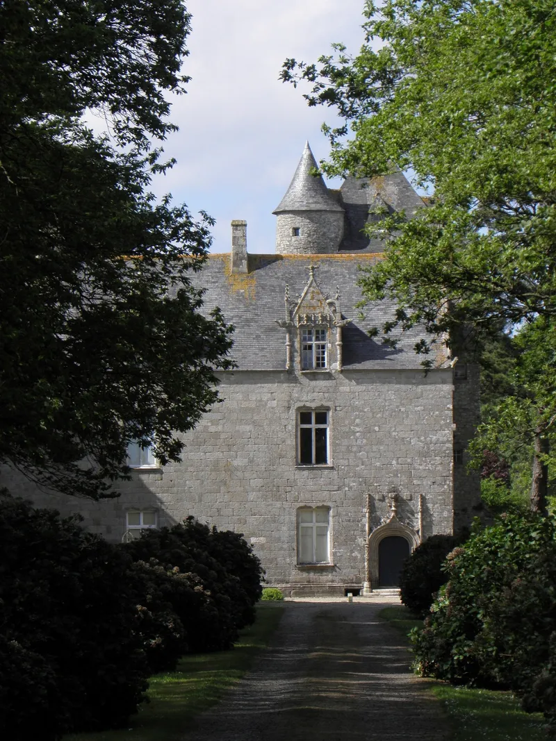
Penmarch Manor
No reviews yet
Have you flown here? Share your experience with other pilots.
+ Write the first reviewHistory
16e siècle Gentilhommière bretonne datant du 16e siècle (vers 1540) avec une tour isolée semblant du 15e. Le corps de logis possède, côté ouest, une aile en retour et, du côté opposé, un donjon carré en saillie. Les fenêtres du premier étage et des mansardes ont des meneaux cruciformes. Les façades donnant sur la cour d'entrée sont percées de lucarnes à pignon décoré de pinacles et de crochets, ainsi que d'une porte à arc surbaissé et accoladé. La tour isolée est de plan circulaire et couronnée de mâchicoulis. Cette tour renferme une salle carrée avec cheminée Renaissance.
Map and restricted areas
Open in the main mapRestricted zones
| Zone | Category | Limits | Conditions |
|---|---|---|---|
| Ctr Bretagne |
Zone de contrôle civile | 50 m above ground level → 457 m above sea level | Flights above 50 metres are forbidden without the prior agreement of air traffic control |
| Tma Iroise |
Région de contrôle terminal | 457 m above sea level → 6259 m above sea level · 762 m above sea level → 3821 m above sea level · 762 m above sea level → 6259 m above sea level · 1372 m above sea level → 6259 m above sea level · 3053 m above sea level → 6259 m above sea level | Drone flights inside this zone are forbidden without the prior agreement of air traffic control |
| D 7 | Zone dangereuse | 5491 m above sea level → 9612 m above sea level | Vols interdits sauf lorsque the official document of the zone l'autorise explicitement ou avec l'accord du gestionnaire de la zone lorsqu'il est désigné par the official document of the zone |
| Zena Atlantique | Zone dangereuse | 5491 m above sea level → 9612 m above sea level | Vols interdits sauf lorsque the official document of the zone l'autorise explicitement ou avec l'accord du gestionnaire de la zone lorsqu'il est désigné par the official document of the zone |
Nearby aerodromes
Open aerodromes within 25 km of the spot, heliports included, with their distance and direction from the spot. Near an aerodrome, drone flying is prohibited or height-limited: check the UAS zones map.
| Aerodrome | Type | Distance | Elevation |
|---|---|---|---|
| Brest Bretagne Airport | Airport | 15 km S | 99 m |
| Landivisiau Air Base | Airport | 19 km E | 106 m |
| La Cavale Blanche Centre Hospitalier Heliport | Heliport | 23 km SW | 37 m |
| Amirauté Heliport | Heliport | 24 km S | 2 m |
Aviation weather (METAR and TAF)
LFRB – Brest Bretagne Airport MVFR
METAR
METAR LFRB 171400Z AUTO 23029G48KT 7000 -RA FEW025/// OVC063/// ///CB 12/11 Q0987 RERA TEMPO 3000 SHRA BKN012 SCT020CB SCT025
- Wind
- 230°, 54 km/h, gusts 89 km/h
- Visibility
- 7 km
- Weather
- Rain light
- Clouds
- Few (1-2/8) at 2,500 ft (760 m) ; Overcast (8/8) at 6,300 ft (1920 m)
- Temperature
- 12 °C, dew point 11 °C
- QNH
- 987 hPa
- Flight category
- MVFR: ceiling 1,000–3,000 ft or visibility 3–5 mi
TAF
TAF LFRB 171100Z 1712/1818 24020G30KT 9999 BKN020 TEMPO 1712/1812 25020G40KT 3000 SHRA BKN012 SCT020CB SCT025TCU PROB40 TEMPO 1712/1715 24025G50KT 1400 TSRAGS BKN009 BKN020CB PROB40 TEMPO 1800/1809 1400 TSRA BECMG 1814/1817 20020G30KT TEMPO 1816/1818 3000 SHRA BKN012 SCT020CB SCT025TCU PROB40 TEMPO 1816/1818 20025G50KT 1400 TSRAGS BKN009 BKN020CB
| Period (local time) | Change | Wind | Visibility | Weather | Clouds |
|---|---|---|---|---|---|
| 17/11 13:00 → 18/11 15:00 | Initial conditions | 240°, 37 km/h, gusts 56 km/h | 10 km or more | Broken (5-7/8) at 2,000 ft (610 m) | |
| 17/11 13:00 → 18/11 13:00 | Temporarily | 250°, 37 km/h, gusts 74 km/h | 3.0 km | Showers of rain | Broken (5-7/8) at 1,200 ft (370 m) ; Scattered (3-4/8) at 2,000 ft (610 m) (cumulonimbus) ; Scattered (3-4/8) at 2,500 ft (760 m) (towering cumulus) |
| 17/11 13:00 → 17/11 16:00 | Temporarily, probability 40% | 240°, 46 km/h, gusts 93 km/h | 1.4 km | Thunderstorm rain ; thunderstorm small hail | Broken (5-7/8) at 900 ft (270 m) ; Broken (5-7/8) at 2,000 ft (610 m) (cumulonimbus) |
| 18/11 01:00 → 18/11 10:00 | Temporarily, probability 40% | 1.4 km | Thunderstorm rain | ||
| 18/11 15:00 → 18/11 19:00 | Becoming | 200°, 37 km/h, gusts 56 km/h | 10 km or more | Broken (5-7/8) at 2,000 ft (610 m) | |
| 18/11 17:00 → 18/11 19:00 | Temporarily | 3.0 km | Showers of rain | Broken (5-7/8) at 1,200 ft (370 m) ; Scattered (3-4/8) at 2,000 ft (610 m) (cumulonimbus) ; Scattered (3-4/8) at 2,500 ft (760 m) (towering cumulus) | |
| 18/11 17:00 → 18/11 19:00 | Temporarily, probability 40% | 200°, 46 km/h, gusts 93 km/h | 1.4 km | Thunderstorm rain ; thunderstorm small hail | Broken (5-7/8) at 900 ft (270 m) ; Broken (5-7/8) at 2,000 ft (610 m) (cumulonimbus) |
Weather and Kp index
Sunrise and sunset
| Day | Dawn | Sunrise | Golden hour | Sunset | Dusk | Day length |
|---|---|---|---|---|---|---|
| Tue 17 Nov | 07:54 | 08:29 | 08:29–09:18 · 16:47–17:36 | 17:36 | 18:11 | 9 h 07 |
| Wed 18 Nov | 07:56 | 08:30 | 08:30–09:20 · 16:45–17:35 | 17:35 | 18:10 | 9 h 04 |
| Thu 19 Nov | 07:57 | 08:32 | 08:32–09:22 · 16:44–17:34 | 17:34 | 18:09 | 9 h 02 |
| Fri 20 Nov | 07:59 | 08:33 | 08:33–09:24 · 16:43–17:33 | 17:33 | 18:08 | 8 h 59 |
| Sat 21 Nov | 08:00 | 08:35 | 08:35–09:25 · 16:42–17:32 | 17:32 | 18:07 | 8 h 57 |
| Sun 22 Nov | 08:01 | 08:36 | 08:36–09:27 · 16:40–17:31 | 17:31 | 18:06 | 8 h 54 |
| Mon 23 Nov | 08:03 | 08:38 | 08:38–09:29 · 16:39–17:30 | 17:30 | 18:05 | 8 h 52 |


Reviews (0)
Log in to review this spot. Log in · Create a free account
No reviews yet. Share yours!