

Former Radar Station
No reviews yet
Have you flown here? Share your experience with other pilots.
+ Write the first reviewHistory
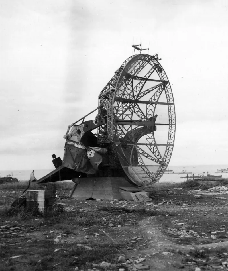
2e quart 20e siècle Dominant la grande rade du port artificiel allié, cette station comprenait deux radars : un radar Seetakt-Gema (spécialisé dans le repérage des bâtiments de surface) posé sur un socle en béton et un grand Würzburg fixé sur une structure octogonale encore visible. Quelques installations annexes complétaient la position : poste d'observation, abris enterrés, poste de télémétrie, etc. La station radar est un témoignage de la haute technologie élaborée par l'armée allemande dans le cadre de la guerre contre l'Angleterre.
Map and restricted areas
Open in the main mapRestricted zones
| Zone | Category | Limits | Conditions |
|---|---|---|---|
| Videcoq | Zone réglementée | 3053 m above sea level → 6259 m above sea level | Vols interdits sauf lorsque the official document of the zone l'autorise explicitement ou avec l'accord du gestionnaire de la zone lorsqu'il est désigné par the official document of the zone |
Nearby aerodromes
Open aerodromes within 25 km of the spot, heliports included, with their distance and direction from the spot. Near an aerodrome, drone flying is prohibited or height-limited: check the UAS zones map.
| Aerodrome | Type | Distance | Elevation |
|---|---|---|---|
| Base ULM de Courseulles sur mer | Aerodrome | 12 km E | 46 m |
| Caen-Carpiquet Airport | Airport | 21 km SE | 78 m |
| Centre Hospitalie Heliport | Heliport | 24 km SE | 67 m |
Aviation weather (METAR and TAF)
LFRK – Caen-Carpiquet Airport VFR
METAR
METAR LFRK 171400Z AUTO 22019KT 9999 RA SCT028/// BKN033/// BKN056/// ///TCU 14/11 Q0987 TEMPO 25020G42KT 1400 TSRAGS BKN008 BKN020CB
- Wind
- 220°, 35 km/h
- Visibility
- 10 km or more
- Weather
- Rain
- Clouds
- Scattered (3-4/8) at 2,800 ft (850 m) ; Broken (5-7/8) at 3,300 ft (1010 m) ; Broken (5-7/8) at 5,600 ft (1710 m)
- Temperature
- 14 °C, dew point 11 °C
- QNH
- 987 hPa
- Flight category
- VFR: ceiling > 3,000 ft and visibility > 5 mi
TAF
TAF LFRK 171400Z 1715/1724 25020G30KT 9999 BKN020 TEMPO 1715/1724 3000 SHRA BKN012 BKN020TCU SCT025CB TEMPO 1715/1718 25020G42KT PROB40 TEMPO 1715/1718 1400 TSRAGS BKN008 BKN020CB
| Period (local time) | Change | Wind | Visibility | Weather | Clouds |
|---|---|---|---|---|---|
| 17/11 16:00 → 18/11 01:00 | Initial conditions | 250°, 37 km/h, gusts 56 km/h | 10 km or more | Broken (5-7/8) at 2,000 ft (610 m) | |
| 17/11 16:00 → 18/11 01:00 | Temporarily | 3.0 km | Showers of rain | Broken (5-7/8) at 1,200 ft (370 m) ; Broken (5-7/8) at 2,000 ft (610 m) (towering cumulus) ; Scattered (3-4/8) at 2,500 ft (760 m) (cumulonimbus) | |
| 17/11 16:00 → 17/11 19:00 | Temporarily | 250°, 37 km/h, gusts 78 km/h | |||
| 17/11 16:00 → 17/11 19:00 | Temporarily, probability 40% | 1.4 km | Thunderstorm rain ; thunderstorm small hail | Broken (5-7/8) at 800 ft (240 m) ; Broken (5-7/8) at 2,000 ft (610 m) (cumulonimbus) |
Weather and Kp index
Sunrise and sunset
| Day | Dawn | Sunrise | Golden hour | Sunset | Dusk | Day length |
|---|---|---|---|---|---|---|
| Tue 17 Nov | 07:41 | 08:16 | 08:16–09:07 · 16:28–17:19 | 17:19 | 17:54 | 9 h 02 |
| Wed 18 Nov | 07:43 | 08:18 | 08:18–09:09 · 16:27–17:18 | 17:18 | 17:53 | 8 h 59 |
| Thu 19 Nov | 07:44 | 08:19 | 08:19–09:10 · 16:25–17:16 | 17:16 | 17:52 | 8 h 57 |
| Fri 20 Nov | 07:45 | 08:21 | 08:21–09:12 · 16:24–17:15 | 17:15 | 17:51 | 8 h 54 |
| Sat 21 Nov | 07:47 | 08:22 | 08:22–09:14 · 16:23–17:14 | 17:14 | 17:50 | 8 h 52 |
| Sun 22 Nov | 07:48 | 08:24 | 08:24–09:16 · 16:21–17:13 | 17:13 | 17:49 | 8 h 49 |
| Mon 23 Nov | 07:50 | 08:25 | 08:25–09:17 · 16:20–17:12 | 17:12 | 17:48 | 8 h 47 |


Reviews (0)
Log in to review this spot. Log in · Create a free account
No reviews yet. Share yours!