

Limoëlan Castles
No reviews yet
Have you flown here? Share your experience with other pilots.
+ Write the first reviewHistory
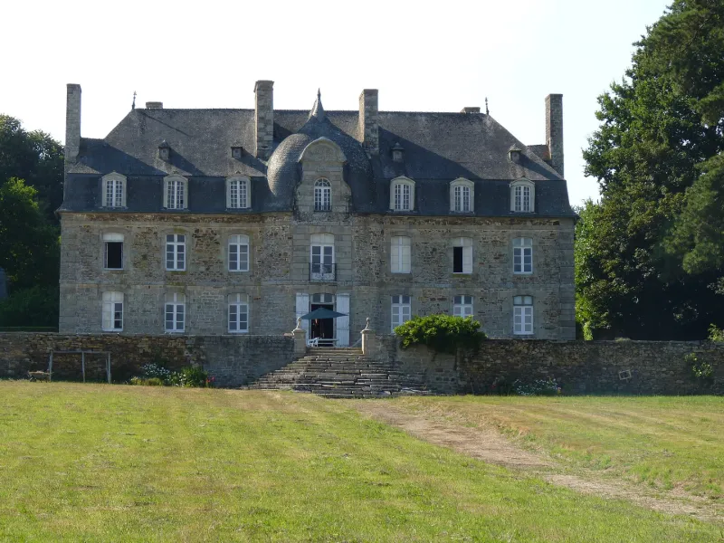
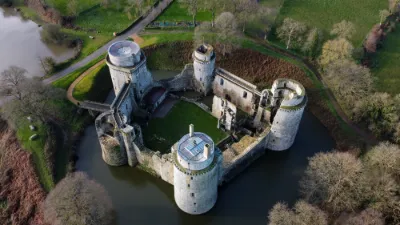
4e quart 18e siècle Il existe deux châteaux de Limoëlan : le premier château de la seigneurie dite de Beaumanoir Beaumont, terre noble possédant le droit de haute justice, fut la propriété des familles Rousselot (14e siècle) , de Dinan (14e-15e siècles) , de la Chapelle de Beuvres (16e siècle) , de Guémadeuc (16e siècle) , de Beaumanoir (16e siècle) , d'Espinay (17e siècle) , de Lorraine (1689). Il fut racheté en 1758 par Michel Julien Alain Picot de Clorivière. Le second château de Limoëlan fut construit par ce dernier acquéreur à 150 mètres de l'ancien château en 1779. Son propriétaire prit alors le nom de Michel Picot de Limoëlan. Il fut pris dans la conspiration du marquis de la Rouerie, arrêté à la Fosse-Hingant et guillotiné à Paris le 18 juin 1793. Son fils, Joseph Picot, dit le Chevalier le Limoëlan, est célèbre pour sa participation à l'affaire de la machine infernale, attentat dirigé contre Bonaparte le soir de Noël 1800. Après la Révolution, Limoëlan fut successivement la propriété des familles Picot de Limoëlan, Bonjour de Limoëlan et de Chappedelaine. De l'ancien château entouré de douves, il ne subsiste qu'une partie à usage de ferme.
Map and restricted areas
Open in the main mapRestricted zones
| Zone | Category | Limits | Conditions |
|---|---|---|---|
| Loudeac | Zone réglementée | 1372 m above sea level → 3821 m above sea level | Vols interdits sauf lorsque the official document of the zone l'autorise explicitement ou avec l'accord du gestionnaire de la zone lorsqu'il est désigné par the official document of the zone |
| Loudeac | Zone réglementée | 3053 m above sea level → 6259 m above sea level | Vols interdits sauf lorsque the official document of the zone l'autorise explicitement ou avec l'accord du gestionnaire de la zone lorsqu'il est désigné par the official document of the zone |
| Argoat | Zone réglementée | 3053 m above sea level → 6259 m above sea level | Vols interdits sauf lorsque the official document of the zone l'autorise explicitement ou avec l'accord du gestionnaire de la zone lorsqu'il est désigné par the official document of the zone |
Nearby aerodromes
Open aerodromes within 25 km of the spot, heliports included, with their distance and direction from the spot. Near an aerodrome, drone flying is prohibited or height-limited: check the UAS zones map.
| Aerodrome | Type | Distance | Elevation |
|---|---|---|---|
| Dinan - Trélivan Airport | Aerodrome | 21 km NE | 120 m |
Aviation weather (METAR and TAF)
LFRD – Dinard-Pleurtuit-Saint-Malo Airport MVFR
METAR
METAR LFRD 171400Z AUTO 23021G36KT 9999 OVC030 OVC036 16/11 Q0988 TEMPO 1400 TSRAGS BKN008 BKN020CB
- Wind
- 230°, 39 km/h, gusts 67 km/h
- Visibility
- 10 km or more
- Clouds
- Overcast (8/8) at 3,000 ft (910 m) ; Overcast (8/8) at 3,600 ft (1100 m)
- Temperature
- 16 °C, dew point 11 °C
- QNH
- 988 hPa
- Flight category
- MVFR: ceiling 1,000–3,000 ft or visibility 3–5 mi
TAF
TAF LFRD 171100Z 1712/1812 25020G30KT 9999 BKN020 TEMPO 1712/1812 3000 SHRA BKN012 SCT020CB SCT025TCU PROB40 TEMPO 1712/1716 23025G45KT 1400 TSRAGS BKN008 BKN020CB PROB30 TEMPO 1800/1806 1400 TSRA
| Period (local time) | Change | Wind | Visibility | Weather | Clouds |
|---|---|---|---|---|---|
| 17/11 13:00 → 18/11 13:00 | Initial conditions | 250°, 37 km/h, gusts 56 km/h | 10 km or more | Broken (5-7/8) at 2,000 ft (610 m) | |
| 17/11 13:00 → 18/11 13:00 | Temporarily | 3.0 km | Showers of rain | Broken (5-7/8) at 1,200 ft (370 m) ; Scattered (3-4/8) at 2,000 ft (610 m) (cumulonimbus) ; Scattered (3-4/8) at 2,500 ft (760 m) (towering cumulus) | |
| 17/11 13:00 → 17/11 17:00 | Temporarily, probability 40% | 230°, 46 km/h, gusts 83 km/h | 1.4 km | Thunderstorm rain ; thunderstorm small hail | Broken (5-7/8) at 800 ft (240 m) ; Broken (5-7/8) at 2,000 ft (610 m) (cumulonimbus) |
| 18/11 01:00 → 18/11 07:00 | Temporarily, probability 30% | 1.4 km | Thunderstorm rain |
Weather and Kp index
Sunrise and sunset
| Day | Dawn | Sunrise | Golden hour | Sunset | Dusk | Day length |
|---|---|---|---|---|---|---|
| Tue 17 Nov | 07:45 | 08:20 | 08:20–09:09 · 16:40–17:29 | 17:29 | 18:03 | 9 h 09 |
| Wed 18 Nov | 07:47 | 08:21 | 08:21–09:11 · 16:38–17:28 | 17:28 | 18:02 | 9 h 06 |
| Thu 19 Nov | 07:48 | 08:23 | 08:23–09:12 · 16:37–17:27 | 17:27 | 18:01 | 9 h 04 |
| Fri 20 Nov | 07:50 | 08:24 | 08:24–09:14 · 16:36–17:26 | 17:26 | 18:00 | 9 h 01 |
| Sat 21 Nov | 07:51 | 08:26 | 08:26–09:16 · 16:35–17:25 | 17:25 | 17:59 | 8 h 59 |
| Sun 22 Nov | 07:52 | 08:27 | 08:27–09:17 · 16:33–17:24 | 17:24 | 17:59 | 8 h 56 |
| Mon 23 Nov | 07:54 | 08:28 | 08:28–09:19 · 16:32–17:23 | 17:23 | 17:58 | 8 h 54 |


Reviews (0)
Log in to review this spot. Log in · Create a free account
No reviews yet. Share yours!