

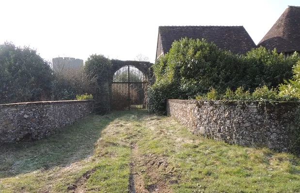
Ruins of Bois-Ruffin Tower and its Outworks
No reviews yet
Have you flown here? Share your experience with other pilots.
+ Write the first reviewHistory
2e moitié 12e siècle La tour paraît avoir été construite à la fin du 12e siècle. En 1421, la tour est occupée par les Bourguignons et les Anglais. Le maréchal de Boucicault, avec les troupes rassemblées à Châteaudun, marcha sur Bois Ruffin et emporta la place. La tour se dresse au fond d'une excavation en entonnoir. Elle est bâtie en grison et gros silex. Elle était autrefois divisée en deux étages, avec entrée au niveau du premier étage. Le remblai résultant du creusement de l'entonnoir a constitué une terrasse circulaire dominant un fossé. Au sommet de ce talus apparaissent les restes d'un mur rejoignant les ruines d'un ouvrage avancé, commandant le pont-levis disparu. Des fossés moins larges encerclent la tour et se prolongent du côté nord pour englober un espace réservé autrefois à des corps de logis, à des granges et à une petite chapelle construite en bois et transformée en maison d'habitation. Le fossé situé en avant était traversé par un pont-levis conduisant à un pavillon de défense avec porte à herse.
Map and restricted areas
Open in the main mapRestricted zones
| Zone | Category | Limits | Conditions |
|---|---|---|---|
| ZRT Puits La Lande | ZRT | From the ground up to about 760 m above sea level | SUP AIP 146/26 · Du jeudi 09 juillet 2026 au samedi 01 mai 2027 |
| Paris 9 | Zone réglementée | 2138 m above sea level → 3821 m above sea level | Vols interdits sauf lorsque the official document of the zone l'autorise explicitement ou avec l'accord du gestionnaire de la zone lorsqu'il est désigné par the official document of the zone |
| ZRT Vald'Yerre | ZRT | 2500 ft AMSL / FL 065 | SUP AIP 146/26 · Du jeudi 09 juillet 2026 au samedi 01 mai 2027 |
Nearby aerodromes
Open aerodromes within 25 km of the spot, heliports included, with their distance and direction from the spot. Near an aerodrome, drone flying is prohibited or height-limited: check the UAS zones map.
No known open aerodrome within 25 km.
Aviation weather (METAR and TAF)
No METAR station within 50 km.
Weather and Kp index
| Day | Weather | Temp. min. / max. | Wind | Rain | Max Kp |
|---|---|---|---|---|---|
| Tue 17 Nov | Light rain | 10° / 14° | 37 km/h SW | 4.9 mm | 5 |
| Wed 18 Nov | Partly cloudy | 10° / 13° | 32 km/h SW | 6.5 mm | 5 |
| Thu 19 Nov | Showers | 8° / 12° | 33 km/h SW | 3.8 mm | 3 |
| Fri 20 Nov | Rain | 8° / 12° | 30 km/h SW | 3.5 mm | 3 |
| Sat 21 Nov | Partly cloudy | 8° / 11° | 25 km/h W | – | – |
| Sun 22 Nov | Rain | 7° / 10° | 24 km/h W | 13 mm | – |
| Mon 23 Nov | Fair | 5° / 11° | 25 km/h W | 0.1 mm | – |
Hour by hour: Tuesday 17 November
| Time | Weather | Temp. | Wind | Rain | Clouds | Kp |
|---|---|---|---|---|---|---|
| 15:00 | Light rain | 14° | 37 km/h SW | 0.2 mm | 99 % | 4 |
| 16:00 | Light rain | 14° | 35 km/h SW | 0.2 mm | 98 % | 4 |
| 17:00 | Rain | 13° | 33 km/h SW | 0.8 mm | 98 % | 4 |
| 18:00 | Heavy rain | 12° | 33 km/h SW | 2.2 mm | 99 % | 4 |
| 19:00 | Heavy rain | 11° | 31 km/h SW | 1.3 mm | 100 % | 5 |
| 20:00 | Light rain | 11° | 33 km/h SW | 0.1 mm | 100 % | 5 |
| 21:00 | Light rain | 12° | 35 km/h SW | 0.1 mm | 91 % | 5 |
| 22:00 | Partly cloudy | 11° | 29 km/h W | – | 78 % | 5 |
Hour by hour: Wednesday 18 November
| Time | Weather | Temp. | Wind | Rain | Clouds | Kp |
|---|---|---|---|---|---|---|
| 06:00 | Cloudy | 10° | 26 km/h SW | – | 99 % | 4 |
| 07:00 | Cloudy | 10° | 26 km/h SW | – | 100 % | 4 |
| 08:00 | Cloudy | 10° | 26 km/h SW | – | 100 % | 4 |
| 09:00 | Cloudy | 10° | 25 km/h SW | – | 100 % | 4 |
| 10:00 | Light rain | 11° | 28 km/h SW | 0.3 mm | 98 % | 4 |
| 11:00 | Fair | 11° | 30 km/h SW | – | 30 % | 4 |
| 12:00 | Fair | 12° | 32 km/h SW | – | 27 % | 4 |
| 13:00 | Partly cloudy | 13° | 32 km/h SW | – | 46 % | 3 |
| 14:00 | Showers | 13° | 31 km/h SW | 0.2 mm | 38 % | 3 |
| 15:00 | Fair | 13° | 28 km/h SW | – | 19 % | 3 |
| 16:00 | Showers | 12° | 26 km/h SW | 0.2 mm | 27 % | 3 |
| 17:00 | Partly cloudy | 11° | 24 km/h SW | – | 66 % | 3 |
| 18:00 | Cloudy | 11° | 22 km/h SW | – | 94 % | 3 |
| 19:00 | Light rain | 11° | 23 km/h SW | 0.2 mm | 100 % | 2 |
| 20:00 | Heavy rain | 11° | 24 km/h SW | 1.2 mm | 100 % | 2 |
| 21:00 | Heavy rain | 10° | 24 km/h S | 1.1 mm | 100 % | 2 |
| 22:00 | Heavy rain | 10° | 26 km/h S | 1.8 mm | 100 % | 2 |
Sunrise and sunset
| Day | Dawn | Sunrise | Golden hour | Sunset | Dusk | Day length |
|---|---|---|---|---|---|---|
| Tue 17 Nov | 07:31 | 08:05 | 08:05–08:54 · 16:27–17:16 | 17:16 | 17:50 | 9 h 10 |
| Wed 18 Nov | 07:33 | 08:07 | 08:07–08:56 · 16:26–17:15 | 17:15 | 17:49 | 9 h 08 |
| Thu 19 Nov | 07:34 | 08:08 | 08:08–08:58 · 16:25–17:14 | 17:14 | 17:48 | 9 h 05 |
| Fri 20 Nov | 07:36 | 08:10 | 08:10–08:59 · 16:23–17:13 | 17:13 | 17:47 | 9 h 03 |
| Sat 21 Nov | 07:37 | 08:11 | 08:11–09:01 · 16:22–17:12 | 17:12 | 17:46 | 9 h 00 |
| Sun 22 Nov | 07:38 | 08:13 | 08:13–09:03 · 16:21–17:11 | 17:11 | 17:46 | 8 h 58 |
| Mon 23 Nov | 07:40 | 08:14 | 08:14–09:04 · 16:20–17:10 | 17:10 | 17:45 | 8 h 56 |

Reviews (0)
Log in to review this spot. Log in · Create a free account
No reviews yet. Share yours!