

Chauveau Lighthouse
No reviews yet
Have you flown here? Share your experience with other pilots.
+ Write the first reviewHistory
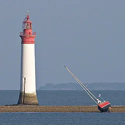
2e quart 19e siècle L'importance du trafic lié au port de La Rochelle et la dangerosité des rochers de Chauveau et de Lavardin ont conduit la commission des phares de 1825 à préconiser la construction de tourelles pour signaler ces écueils. Une simple balise est d'abord posée à Lavardin. Après plusieurs proposés par l'architecte Garnier et supervisés par l'ingénieur Potel, la commission opte pour la construction conjointe d'une tourelle sur le rocher de Lavardin (1841) et d'une tour gardiennée aux rochers du Chauveau. Le feu est allumé le 1er mars 1842. En 1872, un faisceau rouge de 30° de distance angulaire équipe le phare. En 1906, un feu fixe blanc est installé, composé d'une optique de 0,50m de focale et d'une lentille directionnelle de 0,1875m de focale. En 1935 est installé un feu à occultations (2+1), toutes les deux secondes à deux secteurs blancs et rouge. Le phare est automatisé en 1968 avec la mise en place d'un aérogénérateur. Le phare est une tour trompette de 27,30m au-dessus de la mer. Le plateau sur lequel il se dresse est protégé du large par le pertuis et peut être accessible lors des grandes marées. Son couronnement est constitué d'un astragale, d'une gorge elliptique, d'un larmier et d'une cimaise. Initialement prévue pour être pleine et porter un fanal, la tour va être gardiennée. Elle comprend cinq pièces successivement séparées par des calottes en pierre de taille. L'accès d'une pièce à l'autre se fait au moyen d'une échelle de meunier disposée dans un segment cylindrique et appliquée contre le mur de la tour. L'ameublement s'adapte à la forme circulaire de la tour. Le phare de Chauveau reprend un modèle inspiré des Britanniques et mis en oeuvre par Léonce Reynaud au phare des Héaux à Bréhat (1837), considéré comme le modèle parfait.
Map and restricted areas
Open in the main mapRestricted zones
| Zone | Category | Limits | Conditions |
|---|---|---|---|
| Ctr la Rochelle Ile de Re |
Zone de contrôle civile | 50 m above ground level → 610 m above sea level | Flights above 50 metres are forbidden without the prior agreement of air traffic control |
| Bordeaux | Zone réglementée | 5491 m above sea level → 30766 m above sea level | Vols interdits sauf lorsque the official document of the zone l'autorise explicitement ou avec l'accord du gestionnaire de la zone lorsqu'il est désigné par the official document of the zone |
Nearby aerodromes
Open aerodromes within 25 km of the spot, heliports included, with their distance and direction from the spot. Near an aerodrome, drone flying is prohibited or height-limited: check the UAS zones map.
| Aerodrome | Type | Distance | Elevation |
|---|---|---|---|
| La Rochelle-Île de Ré Airport | Airport | 7.9 km NE | 23 m |
| Centre Hospitalier Heliport | Heliport | 10 km E | 15 m |
| St Pierre d'Oléron Airfield | Aerodrome | 20 km S | 6 m |
Aviation weather (METAR and TAF)
LFBH – La Rochelle-Île de Ré Airport MVFR
METAR
METAR LFBH 171400Z AUTO 22014KT 9000 BKN017 OVC024 16/14 Q0999 TEMPO 4500 -SHRA SCT025TCU BECMG 22015G25KT
- Wind
- 220°, 26 km/h
- Visibility
- 9 km
- Clouds
- Broken (5-7/8) at 1,700 ft (520 m) ; Overcast (8/8) at 2,400 ft (730 m)
- Temperature
- 16 °C, dew point 14 °C
- QNH
- 999 hPa
- Flight category
- MVFR: ceiling 1,000–3,000 ft or visibility 3–5 mi
TAF
TAF LFBH 171100Z 1712/1812 21014KT 9999 BKN030 OVC200 BECMG 1712/1715 22015G25KT PROB30 TEMPO 1712/1716 4500 -SHRA SCT025TCU BECMG 1717/1720 25020G35KT 4500 -RA BKN020TCU TEMPO 1719/1721 24030G45KT 2500 TSRA BKN014 BKN020CB BECMG 1720/1722 26015G25KT 9999 NSW SCT020 BKN040 TEMPO 1804/1812 25018G30KT 4500 -SHRA SCT035CB PROB40 TEMPO 1806/1812 2500 -TSRA BKN020CB
| Period (local time) | Change | Wind | Visibility | Weather | Clouds |
|---|---|---|---|---|---|
| 17/11 13:00 → 18/11 13:00 | Initial conditions | 210°, 26 km/h | 10 km or more | Broken (5-7/8) at 3,000 ft (910 m) ; Overcast (8/8) at 20,000 ft (6100 m) | |
| 17/11 13:00 → 17/11 18:00 | Becoming | 220°, 28 km/h, gusts 46 km/h | 10 km or more | Broken (5-7/8) at 3,000 ft (910 m) ; Overcast (8/8) at 20,000 ft (6100 m) | |
| 17/11 13:00 → 17/11 17:00 | Temporarily, probability 30% | 4.5 km | Showers of rain light | Scattered (3-4/8) at 2,500 ft (760 m) (towering cumulus) | |
| 17/11 18:00 → 17/11 21:00 | Becoming | 250°, 37 km/h, gusts 65 km/h | 4.5 km | Rain light | Broken (5-7/8) at 2,000 ft (610 m) (towering cumulus) |
| 17/11 20:00 → 17/11 22:00 | Temporarily | 240°, 56 km/h, gusts 83 km/h | 2.5 km | Thunderstorm rain | Broken (5-7/8) at 1,400 ft (430 m) ; Broken (5-7/8) at 2,000 ft (610 m) (cumulonimbus) |
| 17/11 21:00 → 18/11 13:00 | Becoming | 260°, 28 km/h, gusts 46 km/h | 10 km or more | No significant weather | Scattered (3-4/8) at 2,000 ft (610 m) ; Broken (5-7/8) at 4,000 ft (1220 m) |
| 18/11 05:00 → 18/11 13:00 | Temporarily | 250°, 33 km/h, gusts 56 km/h | 4.5 km | Showers of rain light | Scattered (3-4/8) at 3,500 ft (1070 m) (cumulonimbus) |
| 18/11 07:00 → 18/11 13:00 | Temporarily, probability 40% | 2.5 km | Thunderstorm rain light | Broken (5-7/8) at 2,000 ft (610 m) (cumulonimbus) |
Weather and Kp index
Sunrise and sunset
| Day | Dawn | Sunrise | Golden hour | Sunset | Dusk | Day length |
|---|---|---|---|---|---|---|
| Tue 17 Nov | 07:36 | 08:09 | 08:09–08:55 · 16:45–17:31 | 17:31 | 18:04 | 9 h 22 |
| Wed 18 Nov | 07:37 | 08:10 | 08:10–08:57 · 16:44–17:30 | 17:30 | 18:03 | 9 h 20 |
| Thu 19 Nov | 07:39 | 08:11 | 08:11–08:58 · 16:43–17:29 | 17:29 | 18:02 | 9 h 18 |
| Fri 20 Nov | 07:40 | 08:13 | 08:13–09:00 · 16:42–17:29 | 17:29 | 18:01 | 9 h 15 |
| Sat 21 Nov | 07:41 | 08:14 | 08:14–09:01 · 16:41–17:28 | 17:28 | 18:01 | 9 h 13 |
| Sun 22 Nov | 07:42 | 08:16 | 08:16–09:03 · 16:40–17:27 | 17:27 | 18:00 | 9 h 11 |
| Mon 23 Nov | 07:44 | 08:17 | 08:17–09:04 · 16:39–17:26 | 17:26 | 17:59 | 9 h 09 |


Reviews (0)
Log in to review this spot. Log in · Create a free account
No reviews yet. Share yours!