

Montvallat Castle
No reviews yet
Have you flown here? Share your experience with other pilots.
+ Write the first reviewHistory
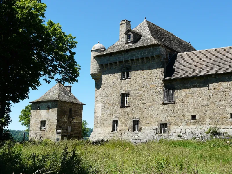
16e siècle ; 1ère moitié 17e siècle Maison forte du 14e siècle, reconstruite au 16e siècle, attaquée pendant les guerres de religion et incendiée en 1610. Montvallat fut en grande partie reconstruit et fortifié à partir de 1612 par François II, comte de Montvallat. Le château forme un quadrilatère, caractérisé par la structure de ses murs (gros blocs de granit et parement de lave de Volvic). Un chemin de ronde à mâchicoulis établi au-dessus des façades joint deux échauguettes couvertes en poivrière. Le corps de logis principal, au sud, sert d'habitation, les autres parties d'exploitation rurale. Dans la première moitié du 17e siècle (vers 1630) , fut réalisé un décor peint italianisant sur panneaux inspiré de gravures contemporaines, d'une finesse étonnante pour une demeure aussi austère : décors de fleurs, feuillages et fruits, scènes mythologiques, petits paysages...
Map and restricted areas
Open in the main mapRestricted zones
| Zone | Category | Limits | Conditions |
|---|---|---|---|
| Zrt Echo Low | ZRT | From the ground up to about 4,100 m above sea level | SUP AIP 219/26 · Du mardi 20 octobre au jeudi 22 octobre 2026 |
| Mende Nord | Zone réglementée | 244 m above ground level → 1768 m above sea level | Vols interdits sauf lorsque the official document of the zone l'autorise explicitement ou avec l'accord du gestionnaire de la zone lorsqu'il est désigné par the official document of the zone |
| Zrt Echo | ZRT | FL 195 / FL 235 | SUP AIP 219/26 · Du mardi 20 octobre au jeudi 22 octobre 2026 |
Nearby aerodromes
Open aerodromes within 25 km of the spot, heliports included, with their distance and direction from the spot. Near an aerodrome, drone flying is prohibited or height-limited: check the UAS zones map.
| Aerodrome | Type | Distance | Elevation |
|---|---|---|---|
| Altisurface de La Taillade | Aerodrome | 3.3 km NW | 888 m |
| Saint-Flour-Coltines Airport | Aerodrome | 23 km N | 981 m |
Aviation weather (METAR and TAF)
LFLW – Aurillac Airport VFR
METAR
METAR LFLW 171330Z AUTO 20004KT 130V250 9999 ////// 12/11 Q1004
- Wind
- 200°, 7 km/h
- Visibility
- 10 km or more
- Clouds
- –
- Temperature
- 12 °C, dew point 11 °C
- QNH
- 1004 hPa
- Flight category
- VFR: ceiling > 3,000 ft and visibility > 5 mi
TAF
TAF LFLW 170500Z 1706/1715 20012KT 4000 RA OVC006 TEMPO 1706/1708 13005KT 9999 NSW BKN030 TEMPO 1708/1714 2000 OVC002 TEMPO 1714/1715 27015G25KT 9999 NSW BKN020
| Period (local time) | Change | Wind | Visibility | Weather | Clouds |
|---|---|---|---|---|---|
| 17/11 07:00 → 17/11 16:00 | Initial conditions | 200°, 22 km/h | 4.0 km | Rain | Overcast (8/8) at 600 ft (180 m) |
| 17/11 07:00 → 17/11 09:00 | Temporarily | 130°, 9 km/h | 10 km or more | No significant weather | Broken (5-7/8) at 3,000 ft (910 m) |
| 17/11 09:00 → 17/11 15:00 | Temporarily | 2.0 km | Overcast (8/8) at 200 ft (60 m) | ||
| 17/11 15:00 → 17/11 16:00 | Temporarily | 270°, 28 km/h, gusts 46 km/h | 10 km or more | No significant weather | Broken (5-7/8) at 2,000 ft (610 m) |
Weather and Kp index
| Day | Weather | Temp. min. / max. | Wind | Rain | Max Kp |
|---|---|---|---|---|---|
| Tue 17 Nov | Heavy rain | 8° / 10° | 28 km/h SW | 9.2 mm | 5 |
| Wed 18 Nov | Rain | 7° / 9° | 33 km/h SW | 13 mm | 5 |
| Thu 19 Nov | Rain | 5° / 9° | 38 km/h S | 22 mm | 3 |
| Fri 20 Nov | Showers | 5° / 7° | 33 km/h SW | 6.4 mm | 3 |
| Sat 21 Nov | Partly cloudy | 5° / 10° | 15 km/h SW | 0.5 mm | – |
| Sun 22 Nov | Light rain | 5° / 8° | 28 km/h W | 12 mm | – |
| Mon 23 Nov | Cloudy | 3° / 8° | 20 km/h W | 0.6 mm | – |
Hour by hour: Tuesday 17 November
| Time | Weather | Temp. | Wind | Rain | Clouds | Kp |
|---|---|---|---|---|---|---|
| 15:00 | Heavy rain | 10° | 26 km/h SW | 1.2 mm | 100 % | 4 |
| 16:00 | Heavy rain | 9° | 28 km/h SW | 1.8 mm | 100 % | 4 |
| 17:00 | Heavy rain | 8° | 20 km/h SW | 2.5 mm | 100 % | 4 |
| 18:00 | Heavy rain | 8° | 23 km/h SW | 1.6 mm | 100 % | 4 |
| 19:00 | Rain | 8° | 24 km/h SW | 0.8 mm | 100 % | 5 |
| 20:00 | Cloudy | 8° | 28 km/h SW | – | 100 % | 5 |
| 21:00 | Cloudy | 8° | 28 km/h SW | – | 100 % | 5 |
| 22:00 | Light rain | 8° | 26 km/h SW | 0.3 mm | 100 % | 5 |
Hour by hour: Wednesday 18 November
| Time | Weather | Temp. | Wind | Rain | Clouds | Kp |
|---|---|---|---|---|---|---|
| 06:00 | Light rain | 8° | 32 km/h SW | 0.2 mm | 100 % | 4 |
| 07:00 | Light rain | 8° | 30 km/h SW | 0.3 mm | 100 % | 4 |
| 08:00 | Light rain | 8° | 30 km/h SW | 0.4 mm | 100 % | 4 |
| 09:00 | Light rain | 8° | 28 km/h W | 0.3 mm | 95 % | 4 |
| 10:00 | Rain | 8° | 29 km/h SW | 0.4 mm | 99 % | 4 |
| 11:00 | Showers | 8° | 28 km/h SW | 0.5 mm | 68 % | 4 |
| 12:00 | Showers | 8° | 26 km/h W | 0.9 mm | 73 % | 4 |
| 13:00 | Rain | 8° | 23 km/h W | 0.9 mm | 97 % | 3 |
| 14:00 | Rain | 8° | 21 km/h W | 1.0 mm | 100 % | 3 |
| 15:00 | Rain | 8° | 24 km/h W | 0.9 mm | 100 % | 3 |
| 16:00 | Light rain | 8° | 22 km/h SW | 0.4 mm | 98 % | 3 |
| 17:00 | Light rain | 8° | 22 km/h SW | 0.2 mm | 98 % | 3 |
| 18:00 | Cloudy | 8° | 21 km/h SW | – | 98 % | 3 |
| 19:00 | Fog | 8° | 21 km/h SW | – | 100 % | 2 |
| 20:00 | Fog | 8° | 21 km/h SW | – | 99 % | 2 |
| 21:00 | Fog | 7° | 18 km/h SW | – | 100 % | 2 |
| 22:00 | Light rain | 7° | 17 km/h S | 0.2 mm | 100 % | 2 |
Sunrise and sunset
| Day | Dawn | Sunrise | Golden hour | Sunset | Dusk | Day length |
|---|---|---|---|---|---|---|
| Tue 17 Nov | 07:16 | 07:48 | 07:48–08:33 · 16:33–17:18 | 17:18 | 17:50 | 9 h 29 |
| Wed 18 Nov | 07:18 | 07:49 | 07:49–08:34 · 16:32–17:17 | 17:17 | 17:49 | 9 h 27 |
| Thu 19 Nov | 07:19 | 07:51 | 07:51–08:36 · 16:31–17:16 | 17:16 | 17:48 | 9 h 25 |
| Fri 20 Nov | 07:20 | 07:52 | 07:52–08:37 · 16:30–17:15 | 17:15 | 17:47 | 9 h 23 |
| Sat 21 Nov | 07:21 | 07:53 | 07:53–08:39 · 16:29–17:15 | 17:15 | 17:47 | 9 h 21 |
| Sun 22 Nov | 07:22 | 07:55 | 07:55–08:40 · 16:28–17:14 | 17:14 | 17:46 | 9 h 19 |
| Mon 23 Nov | 07:24 | 07:56 | 07:56–08:42 · 16:27–17:13 | 17:13 | 17:45 | 9 h 17 |
Reviews (0)
Log in to review this spot. Log in · Create a free account
No reviews yet. Share yours!