

Béost Estate
No reviews yet
Have you flown here? Share your experience with other pilots.
+ Write the first reviewHistory
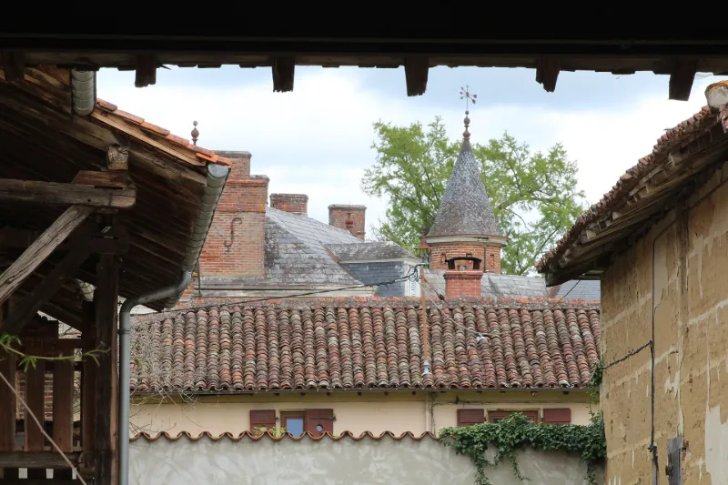
Le domaine se compose d’un logis seigneurial, d’une chapelle, d’une serre, de bâtiments de communs et d’un parc qui s’étend aujourd’hui sur 30 hectares. Trois plans conservés dans les archives privées permettent de suivre l’évolution du tracé du parc entre 1770 et la première moitié du 19e siècle. La palette végétale est principalement issue du 19e siècle, mais demeurent encore quelques sujets du 18e, dont un tilleul et des platanes. Du 19e siècle ont été conservées des essences exotiques (séquoias géants, thuya géant, cèdres du Liban, faux poivrier, tulipier de Virginie). Le corps de ferme, à l’est, regroupe un ensemble intéressant de bâtiments fonctionnels disposés autour d’une cour centrale, dont un pigeonnier, un ancien cuvage, une grange, un bâtiment d’habitation, une porcherie et une étable. La chapelle pourrait constituer la partie la plus ancienne du logis. Entre 1770 et 1801, le plan en fer à cheval du premier logis évolue vers un plan relié au corps de ferme.
Map and restricted areas
Open in the main mapRestricted zones
Nearby aerodromes
Open aerodromes within 25 km of the spot, heliports included, with their distance and direction from the spot. Near an aerodrome, drone flying is prohibited or height-limited: check the UAS zones map.
| Aerodrome | Type | Distance | Elevation |
|---|---|---|---|
| Hôtel Georges Blanc Heliport | Heliport | 2.9 km N | 199 m |
| Crottet-Le Bief ULM | Aerodrome | 13 km NW | 182 m |
| Aérodrome de Mâcon-Charnay | Airport | 19 km NW | 222 m |
| Centre Hospitalier Heliport | Heliport | 19 km NW | 222 m |
| Base Hydro-ULM de Montrevel-en-Bresse | Seaplane base | 20 km NE | 189 m |
Aviation weather (METAR and TAF)
No METAR station within 50 km.
Weather and Kp index
| Day | Weather | Temp. min. / max. | Wind | Rain | Max Kp |
|---|---|---|---|---|---|
| Tue 17 Nov | Fair | 12° / 16° | 30 km/h S | 1.2 mm | 5 |
| Wed 18 Nov | Clear sky | 9° / 16° | 26 km/h S | 2.7 mm | 5 |
| Thu 19 Nov | Fair | 9° / 14° | 33 km/h S | 11 mm | 3 |
| Fri 20 Nov | Rain | 9° / 13° | 23 km/h S | 5.5 mm | 3 |
| Sat 21 Nov | Partly cloudy | 8° / 12° | 14 km/h S | 0.4 mm | – |
| Sun 22 Nov | Fair | 6° / 14° | 16 km/h S | 12 mm | – |
| Mon 23 Nov | Fair | 6° / 11° | 17 km/h S | 0.1 mm | – |
Hour by hour: Tuesday 17 November
| Time | Weather | Temp. | Wind | Rain | Clouds | Kp |
|---|---|---|---|---|---|---|
| 15:00 | Fair | 16° | 22 km/h S | – | 27 % | 4 |
| 16:00 | Fair | 15° | 27 km/h S | – | 21 % | 4 |
| 17:00 | Clear sky | 14° | 28 km/h S | – | 9 % | 4 |
| 18:00 | Clear sky | 13° | 28 km/h S | – | 1 % | 4 |
| 19:00 | Clear sky | 13° | 29 km/h S | – | 12 % | 5 |
| 20:00 | Fair | 12° | 28 km/h S | – | 33 % | 5 |
| 21:00 | Partly cloudy | 12° | 27 km/h S | – | 58 % | 5 |
| 22:00 | Light rain | 13° | 30 km/h S | 0.3 mm | 98 % | 5 |
Hour by hour: Wednesday 18 November
| Time | Weather | Temp. | Wind | Rain | Clouds | Kp |
|---|---|---|---|---|---|---|
| 06:00 | Showers | 11° | 16 km/h SW | 0.1 mm | 39 % | 4 |
| 07:00 | Clear sky | 10° | 13 km/h S | – | 7 % | 4 |
| 08:00 | Clear sky | 9° | 14 km/h S | – | 2 % | 4 |
| 09:00 | Partly cloudy | 11° | 17 km/h SW | – | 41 % | 4 |
| 10:00 | Partly cloudy | 12° | 15 km/h SW | – | 50 % | 4 |
| 11:00 | Fair | 14° | 20 km/h SW | – | 23 % | 4 |
| 12:00 | Fair | 15° | 23 km/h SW | – | 23 % | 4 |
| 13:00 | Clear sky | 15° | 24 km/h SW | – | 11 % | 3 |
| 14:00 | Fair | 16° | 23 km/h SW | – | 19 % | 3 |
| 15:00 | Partly cloudy | 16° | 21 km/h SW | – | 56 % | 3 |
| 16:00 | Partly cloudy | 15° | 18 km/h SW | – | 76 % | 3 |
| 17:00 | Partly cloudy | 13° | 18 km/h SW | – | 81 % | 3 |
| 18:00 | Partly cloudy | 12° | 15 km/h SW | – | 60 % | 3 |
| 19:00 | Partly cloudy | 11° | 14 km/h S | – | 84 % | 2 |
| 20:00 | Partly cloudy | 11° | 17 km/h S | – | 73 % | 2 |
| 21:00 | Partly cloudy | 11° | 21 km/h S | – | 85 % | 2 |
| 22:00 | Cloudy | 11° | 24 km/h S | – | 91 % | 2 |
Sunrise and sunset
| Day | Dawn | Sunrise | Golden hour | Sunset | Dusk | Day length |
|---|---|---|---|---|---|---|
| Tue 17 Nov | 07:11 | 07:44 | 07:44–08:30 · 16:20–17:06 | 17:06 | 17:39 | 9 h 22 |
| Wed 18 Nov | 07:12 | 07:45 | 07:45–08:32 · 16:19–17:05 | 17:05 | 17:38 | 9 h 19 |
| Thu 19 Nov | 07:14 | 07:47 | 07:47–08:33 · 16:17–17:04 | 17:04 | 17:37 | 9 h 17 |
| Fri 20 Nov | 07:15 | 07:48 | 07:48–08:35 · 16:16–17:03 | 17:03 | 17:36 | 9 h 15 |
| Sat 21 Nov | 07:16 | 07:49 | 07:49–08:36 · 16:15–17:02 | 17:02 | 17:35 | 9 h 13 |
| Sun 22 Nov | 07:18 | 07:51 | 07:51–08:38 · 16:14–17:02 | 17:02 | 17:35 | 9 h 11 |
| Mon 23 Nov | 07:19 | 07:52 | 07:52–08:40 · 16:13–17:01 | 17:01 | 17:34 | 9 h 08 |

Reviews (0)
Log in to review this spot. Log in · Create a free account
No reviews yet. Share yours!