

Duesme Castle
No reviews yet
Have you flown here? Share your experience with other pilots.
+ Write the first reviewHistory
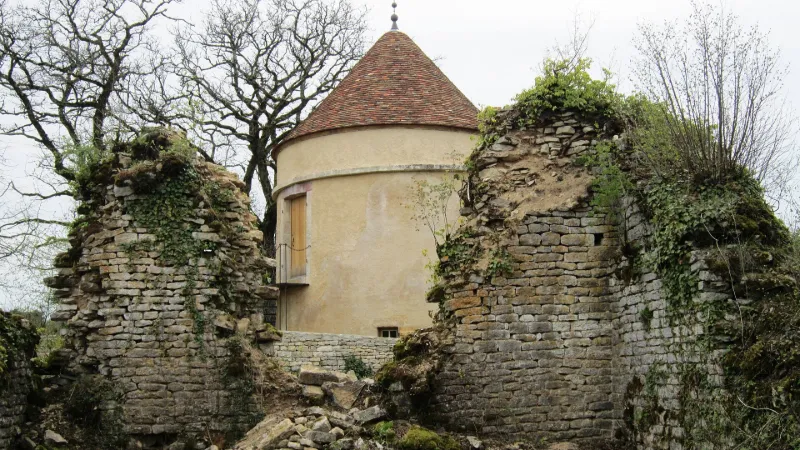
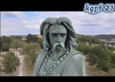
Forteresse bâtie à l'extrémité d'un éperon rocheux, ayant appartenu aux seigneurs de Duesme du 13e au 14e siècle, puis aux ducs de Bourgogne avant de devenir possession de seigneurs engagistes après la réunion à la couronne. Les guerres de Religion dégradent le château, entraînant son démantèlement en 1595, sur ordre de Henri IV, puis sa démolition en 1763. Trois fossés entourent l'édifice, appartenant à des périodes différentes. Le premier date du néolithique. Au-delà du second se trouvaient l'entrée fortifiée, les dépendances et la chapelle dont la crypte conserve des éléments gallo-romains de réemploi. Le donjon se dressait au-delà du troisième fossé.
Map and restricted areas
Open in the main mapRestricted zones
Nearby aerodromes
Open aerodromes within 25 km of the spot, heliports included, with their distance and direction from the spot. Near an aerodrome, drone flying is prohibited or height-limited: check the UAS zones map.
| Aerodrome | Type | Distance | Elevation |
|---|---|---|---|
| Cessey Baigneux les Juifs Airfield | Aerodrome | 6.2 km SW | 358 m |
| Centre d'Etude du C.E.A. Heliport | Heliport | 17 km E | 491 m |
| Châtillon Sur Seine Airfield | Aerodrome | 24 km N | 276 m |
Aviation weather (METAR and TAF)
No METAR station within 50 km.
Weather and Kp index
| Day | Weather | Temp. min. / max. | Wind | Rain | Max Kp |
|---|---|---|---|---|---|
| Tue 17 Nov | Cloudy | 10° / 14° | 36 km/h SW | 1.1 mm | 5 |
| Wed 18 Nov | Showers | 9° / 11° | 33 km/h SW | 5.9 mm | 5 |
| Thu 19 Nov | Showers | 7° / 11° | 33 km/h SW | 12 mm | 3 |
| Fri 20 Nov | Light rain | 7° / 10° | 28 km/h SW | 8.9 mm | 3 |
| Sat 21 Nov | Partly cloudy | 5° / 9° | 26 km/h W | 2.3 mm | – |
| Sun 22 Nov | Showers | 5° / 10° | 25 km/h W | 14 mm | – |
| Mon 23 Nov | Partly cloudy | 5° / 9° | 27 km/h SW | 5.6 mm | – |
Hour by hour: Tuesday 17 November
| Time | Weather | Temp. | Wind | Rain | Clouds | Kp |
|---|---|---|---|---|---|---|
| 15:00 | Cloudy | 14° | 27 km/h SW | – | 100 % | 4 |
| 16:00 | Partly cloudy | 14° | 23 km/h SW | – | 84 % | 4 |
| 17:00 | Partly cloudy | 13° | 27 km/h SW | – | 62 % | 4 |
| 18:00 | Partly cloudy | 13° | 26 km/h SW | – | 67 % | 4 |
| 19:00 | Partly cloudy | 13° | 30 km/h SW | – | 52 % | 5 |
| 20:00 | Showers | 12° | 31 km/h SW | 0.1 mm | 74 % | 5 |
| 21:00 | Light rain | 11° | 34 km/h SW | 0.4 mm | 100 % | 5 |
| 22:00 | Light rain | 10° | 36 km/h SW | 0.4 mm | 99 % | 5 |
Hour by hour: Wednesday 18 November
| Time | Weather | Temp. | Wind | Rain | Clouds | Kp |
|---|---|---|---|---|---|---|
| 06:00 | Rain | 9° | 25 km/h SW | 0.5 mm | 97 % | 4 |
| 07:00 | Rain | 9° | 26 km/h SW | 0.6 mm | 100 % | 4 |
| 08:00 | Heavy rain | 9° | 26 km/h SW | 1.1 mm | 100 % | 4 |
| 09:00 | Heavy rain | 9° | 27 km/h SW | 1.1 mm | 100 % | 4 |
| 10:00 | Rain | 9° | 28 km/h SW | 0.9 mm | 97 % | 4 |
| 11:00 | Showers | 9° | 31 km/h SW | 0.2 mm | 59 % | 4 |
| 12:00 | Showers | 10° | 30 km/h SW | 0.1 mm | 52 % | 4 |
| 13:00 | Showers | 11° | 32 km/h W | 0.2 mm | 78 % | 3 |
| 14:00 | Light rain | 11° | 31 km/h SW | 0.1 mm | 100 % | 3 |
| 15:00 | Showers | 11° | 28 km/h SW | 0.4 mm | 44 % | 3 |
| 16:00 | Showers | 10° | 28 km/h SW | 0.1 mm | 26 % | 3 |
| 17:00 | Fair | 10° | 24 km/h SW | – | 19 % | 3 |
| 18:00 | Fair | 9° | 22 km/h SW | – | 19 % | 3 |
| 19:00 | Partly cloudy | 9° | 21 km/h SW | – | 54 % | 2 |
| 20:00 | Partly cloudy | 9° | 19 km/h SW | – | 59 % | 2 |
| 21:00 | Cloudy | 9° | 20 km/h SW | – | 92 % | 2 |
| 22:00 | Cloudy | 9° | 19 km/h S | – | 99 % | 2 |
Sunrise and sunset
| Day | Dawn | Sunrise | Golden hour | Sunset | Dusk | Day length |
|---|---|---|---|---|---|---|
| Tue 17 Nov | 07:16 | 07:49 | 07:49–08:38 · 16:15–17:03 | 17:03 | 17:37 | 9 h 13 |
| Wed 18 Nov | 07:17 | 07:51 | 07:51–08:39 · 16:13–17:02 | 17:02 | 17:36 | 9 h 11 |
| Thu 19 Nov | 07:18 | 07:52 | 07:52–08:41 · 16:12–17:01 | 17:01 | 17:35 | 9 h 08 |
| Fri 20 Nov | 07:20 | 07:54 | 07:54–08:43 · 16:11–17:00 | 17:00 | 17:34 | 9 h 06 |
| Sat 21 Nov | 07:21 | 07:55 | 07:55–08:44 · 16:10–16:59 | 16:59 | 17:33 | 9 h 03 |
| Sun 22 Nov | 07:22 | 07:57 | 07:57–08:46 · 16:09–16:58 | 16:58 | 17:32 | 9 h 01 |
| Mon 23 Nov | 07:24 | 07:58 | 07:58–08:48 · 16:08–16:57 | 16:57 | 17:32 | 8 h 59 |
Reviews (0)
Log in to review this spot. Log in · Create a free account
No reviews yet. Share yours!