

Hodebert Castle
No reviews yet
Have you flown here? Share your experience with other pilots.
+ Write the first reviewHistory
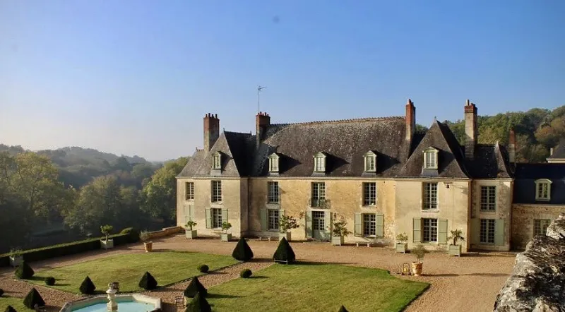
La construction de l'édifice actuel remonte au 17e siècle, sinon à la seconde moitié du 16e siècle, où fut édifié le corps de logis central. Deux séries de pavillons furent ajoutées ensuite, les uns en saillie sur la cour d'honneur, les autres sur la terrasse postérieure. La longue allée du château longe un coteau avant de déboucher sur une vaste cour d'honneur, également bordée au nord par le coteau dont la paroi a été entièrement remodelée par un parement de pierre percé de huit baies cintrées alternativement larges et étroites. Ces baies donnent accès à de profondes caves creusées en berceau dans le massif de tuffeau. Une orangerie a été édifiée au pied du coteau. La cour des communs est disposée perpendiculairement à l'axe de la cour d'honneur et du château, et poursuivie par une basse-cour. Divers bâtiments de communs sont disposés en retrait, masqués par un quinconce planté à l'extrémité de la terrasse ouest du château. Un pavillon de billard en occupe l'angle.
Map and restricted areas
Open in the main mapRestricted zones
Nearby aerodromes
Open aerodromes within 25 km of the spot, heliports included, with their distance and direction from the spot. Near an aerodrome, drone flying is prohibited or height-limited: check the UAS zones map.
No known open aerodrome within 25 km.
Aviation weather (METAR and TAF)
LFRM – Le Mans-Arnage Airport VFR
METAR
METAR LFRM 171400Z AUTO 21014KT 170V260 9999 SCT029 BKN037 OVC060 16/11 Q0993
- Wind
- 210°, 26 km/h
- Visibility
- 10 km or more
- Clouds
- Scattered (3-4/8) at 2,900 ft (880 m) ; Broken (5-7/8) at 3,700 ft (1130 m) ; Overcast (8/8) at 6,000 ft (1830 m)
- Temperature
- 16 °C, dew point 11 °C
- QNH
- 993 hPa
- Flight category
- VFR: ceiling > 3,000 ft and visibility > 5 mi
TAF
Weather and Kp index
Sunrise and sunset
| Day | Dawn | Sunrise | Golden hour | Sunset | Dusk | Day length |
|---|---|---|---|---|---|---|
| Tue 17 Nov | 07:33 | 08:06 | 08:06–08:54 · 16:32–17:20 | 17:20 | 17:54 | 9 h 13 |
| Wed 18 Nov | 07:34 | 08:08 | 08:08–08:56 · 16:30–17:19 | 17:19 | 17:53 | 9 h 11 |
| Thu 19 Nov | 07:35 | 08:09 | 08:09–08:58 · 16:29–17:18 | 17:18 | 17:52 | 9 h 08 |
| Fri 20 Nov | 07:37 | 08:11 | 08:11–08:59 · 16:28–17:17 | 17:17 | 17:51 | 9 h 06 |
| Sat 21 Nov | 07:38 | 08:12 | 08:12–09:01 · 16:27–17:16 | 17:16 | 17:50 | 9 h 04 |
| Sun 22 Nov | 07:39 | 08:13 | 08:13–09:03 · 16:26–17:15 | 17:15 | 17:49 | 9 h 01 |
| Mon 23 Nov | 07:41 | 08:15 | 08:15–09:04 · 16:25–17:14 | 17:14 | 17:49 | 8 h 59 |

Reviews (0)
Log in to review this spot. Log in · Create a free account
No reviews yet. Share yours!