

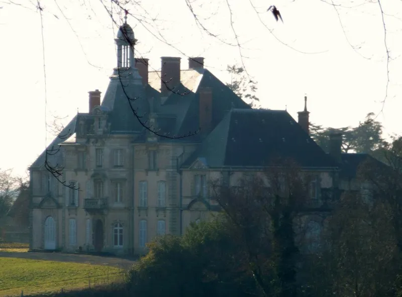
Montmirey-la-Ville Castle (also in the commune of Montmirey-le-Château)
No reviews yet
Have you flown here? Share your experience with other pilots.
+ Write the first reviewHistory
Un fief apparaît au 14ème siècle, la chevance de Villeguindry. Acheté en 1772, le nouveau propriétaire fait construire un logis qui constitue le corps de bâtiment central du logis actuel. Composé de nombreux communs ainsi que d'un moulin, le domaine fut vendu en 1805. L'aménagement du parc remonte à cette période. En1842, deux ailes en retour sur la cour sont bâties. La maison du gardien et l'orangerie sont édifiées en 1850. La façade du logis sur le parc est remodelée à partir de 1873. Une chapelle est aménagée à l'intérieur du logis. Un pavillon situé au nord est ajouté puis, un pavillon au sud, en 1880, afin d'abriter le salon. Enfin, le tracé du parc est élargi en 1884. Le portail est de style néo-médiéval ou néo-normand. Un vaste hall de remises s'ouvre sur la cour dans l'axe du logis dont la façade dominant le parc se déploie dans un style néo-Renaissance avec un avant-corps surmonté d'une haute toiture à belvédère. La chapelle néo-gothique présente des peintures murales et un vitrail figuré. Les décors très soignés avec plafonds peints de la bibliothèque et du salon sont de style néo-Renaissance et la salle à manger renferme des tapisseries de Beauvais. Le parc paysager, parcouru d'allées sinueuses, est traversé par le ruisseau la Brisotte qui alimente un dispositif hydraulique avec étang, déversoir et pièce d'eau. L'allée principale achemine le promeneur au portail sur Montmirey-le-Château. La grille du portail d'honneur est du 18ème siècle.
Map and restricted areas
Open in the main mapRestricted zones
| Zone | Category | Limits | Conditions |
|---|---|---|---|
| Zrt Opal | ZRT | From about 14,950 m to about 16,750 m above sea level | SUP AIP 233/24 · Du 16 janvier 2025 au 13 janvier 2027 |
Nearby aerodromes
Open aerodromes within 25 km of the spot, heliports included, with their distance and direction from the spot. Near an aerodrome, drone flying is prohibited or height-limited: check the UAS zones map.
| Aerodrome | Type | Distance | Elevation |
|---|---|---|---|
| Centre Hospitalier Heliport | Heliport | 15 km S | 265 m |
| Dole-Tavaux Airport | Airport | 20 km S | 197 m |
Aviation weather (METAR and TAF)
LFGJ – Dole-Tavaux Airport VFR
METAR
METAR LFGJ 171400Z AUTO 20018KT CAVOK 17/13 Q0998 TEMPO 21020G35KT SCT020TCU
- Wind
- 200°, 33 km/h
- Visibility
- 10 km or more
- Clouds
- –
- Temperature
- 17 °C, dew point 13 °C
- QNH
- 998 hPa
- Flight category
- VFR: ceiling > 3,000 ft and visibility > 5 mi
TAF
TAF LFGJ 171400Z 1715/1724 21015G25KT CAVOK TEMPO 1715/1718 -SHRA FEW025TCU TEMPO 1721/1724 21020G37KT SHRA SCT040TCU PROB30 TEMPO 1721/1724 FEW035CB
| Period (local time) | Change | Wind | Visibility | Weather | Clouds |
|---|---|---|---|---|---|
| 17/11 16:00 → 18/11 01:00 | Initial conditions | 210°, 28 km/h, gusts 46 km/h | 10 km or more | No significant weather | No significant cloud |
| 17/11 16:00 → 17/11 19:00 | Temporarily | Showers of rain light | Few (1-2/8) at 2,500 ft (760 m) (towering cumulus) | ||
| 17/11 22:00 → 18/11 01:00 | Temporarily | 210°, 37 km/h, gusts 69 km/h | Showers of rain | Scattered (3-4/8) at 4,000 ft (1220 m) (towering cumulus) | |
| 17/11 22:00 → 18/11 01:00 | Temporarily, probability 30% | Few (1-2/8) at 3,500 ft (1070 m) (cumulonimbus) |
Weather and Kp index
Sunrise and sunset
| Day | Dawn | Sunrise | Golden hour | Sunset | Dusk | Day length |
|---|---|---|---|---|---|---|
| Tue 17 Nov | 07:11 | 07:45 | 07:45–08:32 · 16:13–17:01 | 17:01 | 17:34 | 9 h 16 |
| Wed 18 Nov | 07:13 | 07:46 | 07:46–08:34 · 16:12–17:00 | 17:00 | 17:33 | 9 h 13 |
| Thu 19 Nov | 07:14 | 07:48 | 07:48–08:36 · 16:11–16:59 | 16:59 | 17:32 | 9 h 11 |
| Fri 20 Nov | 07:15 | 07:49 | 07:49–08:37 · 16:10–16:58 | 16:58 | 17:32 | 9 h 08 |
| Sat 21 Nov | 07:17 | 07:50 | 07:50–08:39 · 16:09–16:57 | 16:57 | 17:31 | 9 h 06 |
| Sun 22 Nov | 07:18 | 07:52 | 07:52–08:41 · 16:07–16:56 | 16:56 | 17:30 | 9 h 04 |
| Mon 23 Nov | 07:19 | 07:53 | 07:53–08:42 · 16:06–16:55 | 16:55 | 17:29 | 9 h 02 |

Reviews (0)
Log in to review this spot. Log in · Create a free account
No reviews yet. Share yours!