

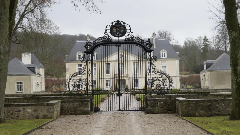
Louvois Castle
No reviews yet
Have you flown here? Share your experience with other pilots.
+ Write the first reviewHistory
En 1678-1681, Louvois fait reconstruire le nouveau château sur l'emplacement du château médiéval et il décide de l'entourer sur un site pourtant difficile à utiliser parce qu'à mi-pente, d'un parc naturel auquel il attache une grande importance si l'on en juge par les personnes chargées de le réaliser. Jules Hardouin-Mansart donne le plan général du parc. Le Nôtre intervient pour le dessin précis de certaines parties. Vauban s'occupe des travaux de terrassement et Le Bouteux, neveu et proche collaborateur de Le Nôtre s'occupe de la composition des parterres. De cet ensemble, les grandes lignes sont encore aujourd'hui parfaitement visibles même si le château a été amputé d'une partie de ses bâtiments et si le détail du dessin des parterres et des bosquets est affecté par différentes restaurations des 19e et 20e siècles.
Map and restricted areas
Open in the main mapRestricted zones
Nearby aerodromes
Open aerodromes within 25 km of the spot, heliports included, with their distance and direction from the spot. Near an aerodrome, drone flying is prohibited or height-limited: check the UAS zones map.
| Aerodrome | Type | Distance | Elevation |
|---|---|---|---|
| Épernay Plivot Airfield | Aerodrome | 12 km S | 88 m |
| Aérodrome de Reims Prunay | Aerodrome | 12 km N | 95 m |
| Centre Vinicole Heliport | Heliport | 14 km SW | 142 m |
| Centre Hospitalier Régional Heliport | Heliport | 15 km NW | 103 m |
| Hôtellerie La Briquetterie Heliport | Heliport | 18 km SW | 100 m |
Aviation weather (METAR and TAF)
LFQA – Aérodrome de Reims Prunay VFR
METAR
METAR LFQA 171400Z AUTO 24016KT 9999 FEW040 SCT110 BKN160 16/09 Q0990
- Wind
- 240°, 30 km/h
- Visibility
- 10 km or more
- Clouds
- Few (1-2/8) at 4,000 ft (1220 m) ; Scattered (3-4/8) at 11,000 ft (3350 m) ; Broken (5-7/8) at 16,000 ft (4880 m)
- Temperature
- 16 °C, dew point 9 °C
- QNH
- 990 hPa
- Flight category
- VFR: ceiling > 3,000 ft and visibility > 5 mi
TAF
Weather and Kp index
| Day | Weather | Temp. min. / max. | Wind | Rain | Max Kp |
|---|---|---|---|---|---|
| Tue 17 Nov | Cloudy | 11° / 15° | 32 km/h SW | 5.6 mm | 5 |
| Wed 18 Nov | Showers | 9° / 13° | 30 km/h SW | 2.5 mm | 5 |
| Thu 19 Nov | Partly cloudy | 8° / 12° | 33 km/h SW | 5.5 mm | 3 |
| Fri 20 Nov | Showers | 9° / 12° | 25 km/h SW | 3.6 mm | 3 |
| Sat 21 Nov | Clear sky | 4° / 9° | 24 km/h SW | 0.7 mm | – |
| Sun 22 Nov | Rain | 2° / 7° | 13 km/h E | 6.8 mm | – |
| Mon 23 Nov | Fair | 5° / 10° | 19 km/h W | 0.5 mm | – |
Hour by hour: Tuesday 17 November
| Time | Weather | Temp. | Wind | Rain | Clouds | Kp |
|---|---|---|---|---|---|---|
| 15:00 | Cloudy | 15° | 27 km/h SW | – | 96 % | 4 |
| 16:00 | Showers | 15° | 24 km/h SW | 1.0 mm | 71 % | 4 |
| 17:00 | Light rain | 12° | 27 km/h SW | 0.4 mm | 98 % | 4 |
| 18:00 | Light rain | 11° | 26 km/h SW | 0.3 mm | 98 % | 4 |
| 19:00 | Heavy rain | 11° | 28 km/h SW | 1.6 mm | 100 % | 5 |
| 20:00 | Heavy rain | 11° | 29 km/h SW | 1.5 mm | 98 % | 5 |
| 21:00 | Rain | 11° | 32 km/h SW | 0.5 mm | 100 % | 5 |
| 22:00 | Light rain | 11° | 30 km/h SW | 0.3 mm | 100 % | 5 |
Hour by hour: Wednesday 18 November
| Time | Weather | Temp. | Wind | Rain | Clouds | Kp |
|---|---|---|---|---|---|---|
| 06:00 | Cloudy | 10° | 26 km/h SW | – | 100 % | 4 |
| 07:00 | Cloudy | 10° | 26 km/h SW | – | 97 % | 4 |
| 08:00 | Cloudy | 10° | 25 km/h SW | – | 96 % | 4 |
| 09:00 | Partly cloudy | 10° | 24 km/h SW | – | 82 % | 4 |
| 10:00 | Showers | 11° | 26 km/h SW | 0.2 mm | 70 % | 4 |
| 11:00 | Showers | 11° | 30 km/h SW | 0.4 mm | 79 % | 4 |
| 12:00 | Showers | 11° | 30 km/h SW | 0.3 mm | 40 % | 4 |
| 13:00 | Showers | 12° | 30 km/h SW | 0.3 mm | 35 % | 3 |
| 14:00 | Fair | 12° | 30 km/h SW | – | 21 % | 3 |
| 15:00 | Showers | 13° | 27 km/h SW | 0.3 mm | 79 % | 3 |
| 16:00 | Clear sky | 11° | 25 km/h SW | – | 11 % | 3 |
| 17:00 | Clear sky | 10° | 19 km/h SW | – | 6 % | 3 |
| 18:00 | Fair | 10° | 20 km/h SW | – | 19 % | 3 |
| 19:00 | Partly cloudy | 10° | 19 km/h SW | – | 43 % | 2 |
| 20:00 | Partly cloudy | 10° | 18 km/h SW | – | 58 % | 2 |
| 21:00 | Cloudy | 9° | 17 km/h SW | – | 94 % | 2 |
| 22:00 | Cloudy | 10° | 19 km/h S | – | 99 % | 2 |
Sunrise and sunset
| Day | Dawn | Sunrise | Golden hour | Sunset | Dusk | Day length |
|---|---|---|---|---|---|---|
| Tue 17 Nov | 07:22 | 07:56 | 07:56–08:47 · 16:10–17:00 | 17:00 | 17:35 | 9 h 04 |
| Wed 18 Nov | 07:23 | 07:58 | 07:58–08:49 · 16:09–16:59 | 16:59 | 17:34 | 9 h 01 |
| Thu 19 Nov | 07:24 | 08:00 | 08:00–08:50 · 16:07–16:58 | 16:58 | 17:33 | 8 h 58 |
| Fri 20 Nov | 07:26 | 08:01 | 08:01–08:52 · 16:06–16:57 | 16:57 | 17:32 | 8 h 56 |
| Sat 21 Nov | 07:27 | 08:03 | 08:03–08:54 · 16:05–16:56 | 16:56 | 17:32 | 8 h 53 |
| Sun 22 Nov | 07:29 | 08:04 | 08:04–08:56 · 16:04–16:55 | 16:55 | 17:31 | 8 h 51 |
| Mon 23 Nov | 07:30 | 08:05 | 08:05–08:57 · 16:03–16:54 | 16:54 | 17:30 | 8 h 48 |

Reviews (0)
Log in to review this spot. Log in · Create a free account
No reviews yet. Share yours!