

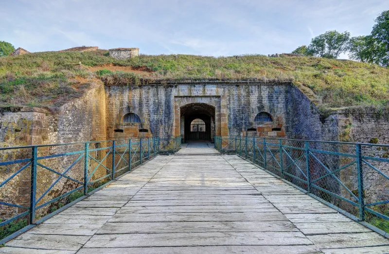
Vercingétorix Fort of Cognelot
No reviews yet
Have you flown here? Share your experience with other pilots.
+ Write the first reviewHistory
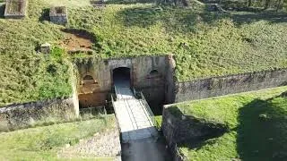
Le fort, en relativement bon état, appartient à la ceinture fortifiée de Langres mise en place après la guerre de 1870, et édifié selon les normes édictées par l'ingénieur Séré de Rivières, fondées sur le principe de la fortification polygonale, de la rationalisation à l'extrême des éléments architecturaux et de la construction quasi-souterraine. Il demeure néanmoins atypique par rapport à ses contemporains. En effet, l'élément défensif rencontré dans les premiers forts de Séné, les saponnières, est ici remplacé par des coffres d'escarpe et de contre-escarpe. De plus, Cognelot relève d'une catégorie mixte, à la fois conçu pour se défendre seul mais également interdépendant des autres édifices du dispositif de défense.
Map and restricted areas
Open in the main mapRestricted zones
| Zone | Category | Limits | Conditions |
|---|---|---|---|
| Langres | Zone réglementée | 244 m above ground level → 2297 m above sea level | Vols interdits sauf lorsque the official document of the zone l'autorise explicitement ou avec l'accord du gestionnaire de la zone lorsqu'il est désigné par the official document of the zone |
Nearby aerodromes
Open aerodromes within 25 km of the spot, heliports included, with their distance and direction from the spot. Near an aerodrome, drone flying is prohibited or height-limited: check the UAS zones map.
| Aerodrome | Type | Distance | Elevation |
|---|---|---|---|
| Langres Rolampont Airfield | Aerodrome | 19 km NW | 420 m |
Aviation weather (METAR and TAF)
No METAR station within 50 km.
Weather and Kp index
| Day | Weather | Temp. min. / max. | Wind | Rain | Max Kp |
|---|---|---|---|---|---|
| Tue 17 Nov | Cloudy | 10° / 15° | 33 km/h SW | 2.1 mm | 5 |
| Wed 18 Nov | Showers | 8° / 12° | 33 km/h W | 2.3 mm | 5 |
| Thu 19 Nov | Showers | 8° / 11° | 32 km/h SW | 14 mm | 3 |
| Fri 20 Nov | Light rain | 8° / 11° | 28 km/h SW | 7.2 mm | 3 |
| Sat 21 Nov | Partly cloudy | 5° / 10° | 23 km/h SW | 0.8 mm | – |
| Sun 22 Nov | Light rain | 4° / 7° | 17 km/h SW | 13 mm | – |
| Mon 23 Nov | Cloudy | 5° / 9° | 20 km/h W | 2.9 mm | – |
Hour by hour: Tuesday 17 November
| Time | Weather | Temp. | Wind | Rain | Clouds | Kp |
|---|---|---|---|---|---|---|
| 15:00 | Cloudy | 15° | 26 km/h SW | – | 98 % | 4 |
| 16:00 | Cloudy | 14° | 24 km/h SW | – | 98 % | 4 |
| 17:00 | Cloudy | 13° | 24 km/h SW | – | 89 % | 4 |
| 18:00 | Partly cloudy | 13° | 25 km/h SW | – | 51 % | 4 |
| 19:00 | Cloudy | 12° | 26 km/h SW | – | 99 % | 5 |
| 20:00 | Partly cloudy | 12° | 29 km/h SW | – | 84 % | 5 |
| 21:00 | Showers | 12° | 31 km/h SW | 0.3 mm | 66 % | 5 |
| 22:00 | Rain | 11° | 33 km/h SW | 0.9 mm | 100 % | 5 |
Hour by hour: Wednesday 18 November
| Time | Weather | Temp. | Wind | Rain | Clouds | Kp |
|---|---|---|---|---|---|---|
| 06:00 | Partly cloudy | 10° | 27 km/h SW | – | 80 % | 4 |
| 07:00 | Showers | 10° | 27 km/h SW | 0.2 mm | 71 % | 4 |
| 08:00 | Light rain | 9° | 27 km/h SW | 0.2 mm | 98 % | 4 |
| 09:00 | Light rain | 10° | 28 km/h SW | 0.3 mm | 95 % | 4 |
| 10:00 | Rain | 10° | 31 km/h SW | 0.4 mm | 95 % | 4 |
| 11:00 | Showers | 10° | 32 km/h SW | 0.2 mm | 52 % | 4 |
| 12:00 | Showers | 11° | 29 km/h W | 0.2 mm | 26 % | 4 |
| 13:00 | Showers | 12° | 33 km/h W | 0.4 mm | 52 % | 3 |
| 14:00 | Showers | 11° | 32 km/h W | 0.3 mm | 44 % | 3 |
| 15:00 | Partly cloudy | 11° | 30 km/h W | – | 51 % | 3 |
| 16:00 | Partly cloudy | 11° | 27 km/h W | – | 38 % | 3 |
| 17:00 | Fair | 10° | 23 km/h SW | – | 27 % | 3 |
| 18:00 | Clear sky | 10° | 22 km/h SW | – | 6 % | 3 |
| 19:00 | Clear sky | 9° | 22 km/h SW | – | 12 % | 2 |
| 20:00 | Partly cloudy | 9° | 18 km/h SW | – | 56 % | 2 |
| 21:00 | Cloudy | 8° | 18 km/h S | – | 92 % | 2 |
| 22:00 | Cloudy | 8° | 21 km/h S | – | 100 % | 2 |
Sunrise and sunset
| Day | Dawn | Sunrise | Golden hour | Sunset | Dusk | Day length |
|---|---|---|---|---|---|---|
| Tue 17 Nov | 07:13 | 07:47 | 07:47–08:36 · 16:11–17:00 | 17:00 | 17:33 | 9 h 12 |
| Wed 18 Nov | 07:15 | 07:49 | 07:49–08:37 · 16:10–16:59 | 16:59 | 17:32 | 9 h 09 |
| Thu 19 Nov | 07:16 | 07:50 | 07:50–08:39 · 16:09–16:57 | 16:57 | 17:32 | 9 h 07 |
| Fri 20 Nov | 07:17 | 07:51 | 07:51–08:41 · 16:07–16:57 | 16:57 | 17:31 | 9 h 05 |
| Sat 21 Nov | 07:19 | 07:53 | 07:53–08:42 · 16:06–16:56 | 16:56 | 17:30 | 9 h 02 |
| Sun 22 Nov | 07:20 | 07:54 | 07:54–08:44 · 16:05–16:55 | 16:55 | 17:29 | 9 h 00 |
| Mon 23 Nov | 07:21 | 07:56 | 07:56–08:45 · 16:04–16:54 | 16:54 | 17:28 | 8 h 58 |
Reviews (0)
Log in to review this spot. Log in · Create a free account
No reviews yet. Share yours!