

Former Castle Park
No reviews yet
Have you flown here? Share your experience with other pilots.
+ Write the first reviewHistory
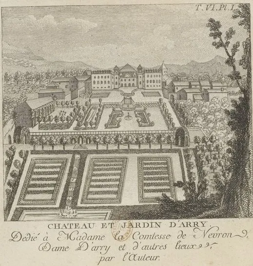
Château construit entre 1714 et 1743 à l'emplacement d'une ancienne maison forte. Jardins aménagés à la même période. Château rasé en 1946, après les destructions de la seconde guerre mondiale. Sur le site du château, les jardins subsistent, ordonnés en terrasses, sur trois axes. L'axe médian, en creux, est embelli d'un escalier en X (courbes et contre-courbes de style Louis XV) franchissant une chute d'eau qui se déverse dans un canal, à l'extrémité duquel trois arcades ouvrent sur le niveau bas du jardin. Mis au goût du jour dans la première moitié du 19e siècle, le parcours fut alors naturalisé et des essences, comme le hêtre à feuilles laciniées, furent plantées en partie basse.
Map and restricted areas
Open in the main mapRestricted zones
| Zone | Category | Limits | Conditions |
|---|---|---|---|
| Tma Lorraine |
Région de contrôle terminal | 914 m above sea level → 2602 m above sea level · 1158 m above sea level → 2602 m above sea level · 1219 m above sea level → 2297 m above sea level · 1219 m above sea level → 2602 m above sea level · 1219 m above sea level → 3821 m above sea level · 1224 m above sea level → 2602 m above sea level · 1834 m above sea level → 3821 m above sea level · 1834 m above sea level → 3821 m above sea level | Drone flights inside this zone are forbidden without the prior agreement of air traffic control |
| Saint Dizier | Zone réglementée | 3053 m above sea level → 6259 m above sea level | Vols interdits sauf lorsque the official document of the zone l'autorise explicitement ou avec l'accord du gestionnaire de la zone lorsqu'il est désigné par the official document of the zone |
Nearby aerodromes
Open aerodromes within 25 km of the spot, heliports included, with their distance and direction from the spot. Near an aerodrome, drone flying is prohibited or height-limited: check the UAS zones map.
| Aerodrome | Type | Distance | Elevation |
|---|---|---|---|
| Chambley-Bussières Air Base | Aerodrome | 14 km W | 264 m |
| Chambley | Aerodrome | 14 km W | 264 m |
| Metz-Nancy-Lorraine Airport | Airport | 14 km E | 265 m |
| Technopole 2000 Heliport | Heliport | 17 km NE | 220 m |
| Doncourt Les Conflans Airfield | Aerodrome | 20 km NW | 245 m |
Aviation weather (METAR and TAF)
LFJL – Metz-Nancy-Lorraine Airport VFR
METAR
METAR LFJL 171230Z AUTO 25028KT 9999 BKN031 BKN039 16/11 Q0991 TEMPO 24020G35KT 4000 SHRA SCT020TCU
- Wind
- 250°, 52 km/h
- Visibility
- 10 km or more
- Clouds
- Broken (5-7/8) at 3,100 ft (940 m) ; Broken (5-7/8) at 3,900 ft (1190 m)
- Temperature
- 16 °C, dew point 11 °C
- QNH
- 991 hPa
- Flight category
- VFR: ceiling > 3,000 ft and visibility > 5 mi
TAF
TAF LFJL 171100Z 1712/1812 24015G25KT 9999 OVC025 TEMPO 1712/1812 24020G35KT 4000 SHRA SCT020TCU PROB40 TEMPO 1712/1713 24025G40KT BKN012 PROB40 TEMPO 1721/1724 25025G40KT 2500 +SHRA SCT020CB
| Period (local time) | Change | Wind | Visibility | Weather | Clouds |
|---|---|---|---|---|---|
| 17/11 13:00 → 18/11 13:00 | Initial conditions | 240°, 28 km/h, gusts 46 km/h | 10 km or more | Overcast (8/8) at 2,500 ft (760 m) | |
| 17/11 13:00 → 18/11 13:00 | Temporarily | 240°, 37 km/h, gusts 65 km/h | 4.0 km | Showers of rain | Scattered (3-4/8) at 2,000 ft (610 m) (towering cumulus) |
| 17/11 13:00 → 17/11 14:00 | Temporarily, probability 40% | 240°, 46 km/h, gusts 74 km/h | Broken (5-7/8) at 1,200 ft (370 m) | ||
| 17/11 22:00 → 18/11 01:00 | Temporarily, probability 40% | 250°, 46 km/h, gusts 74 km/h | 2.5 km | Showers of rain heavy | Scattered (3-4/8) at 2,000 ft (610 m) (cumulonimbus) |
Weather and Kp index
| Day | Weather | Temp. min. / max. | Wind | Rain | Max Kp |
|---|---|---|---|---|---|
| Tue 17 Nov | Showers | 10° / 14° | 35 km/h SW | 7.7 mm | 5 |
| Wed 18 Nov | Light rain | 8° / 10° | 32 km/h SW | 5.8 mm | 5 |
| Thu 19 Nov | Cloudy | 8° / 10° | 30 km/h SW | 6.5 mm | 3 |
| Fri 20 Nov | Light rain | 7° / 9° | 27 km/h SW | 8.4 mm | 3 |
| Sat 21 Nov | Clear sky | 3° / 8° | 21 km/h SW | 3.4 mm | – |
| Sun 22 Nov | Rain | 0° / 5° | 13 km/h E | 6.4 mm | – |
| Mon 23 Nov | Cloudy | 5° / 7° | 21 km/h W | 0.6 mm | – |
Hour by hour: Tuesday 17 November
| Time | Weather | Temp. | Wind | Rain | Clouds | Kp |
|---|---|---|---|---|---|---|
| 13:00 | Showers | 13° | 35 km/h SW | 0.2 mm | 70 % | 4 |
| 14:00 | Partly cloudy | 14° | 30 km/h SW | – | 50 % | 4 |
| 15:00 | Fair | 14° | 30 km/h SW | – | 14 % | 4 |
| 16:00 | Partly cloudy | 13° | 26 km/h SW | – | 56 % | 4 |
| 17:00 | Rain | 12° | 26 km/h SW | 0.7 mm | 98 % | 4 |
| 18:00 | Heavy rain | 11° | 24 km/h SW | 1.1 mm | 93 % | 4 |
| 19:00 | Rain | 10° | 26 km/h SW | 0.4 mm | 100 % | 5 |
| 20:00 | Heavy rain | 10° | 26 km/h SW | 1.2 mm | 100 % | 5 |
| 21:00 | Heavy rain | 10° | 24 km/h SW | 1.6 mm | 100 % | 5 |
| 22:00 | Heavy rain | 10° | 32 km/h SW | 1.6 mm | 99 % | 5 |
Hour by hour: Wednesday 18 November
| Time | Weather | Temp. | Wind | Rain | Clouds | Kp |
|---|---|---|---|---|---|---|
| 06:00 | Light rain | 9° | 27 km/h SW | 0.3 mm | 100 % | 4 |
| 07:00 | Rain | 9° | 28 km/h SW | 0.5 mm | 100 % | 4 |
| 08:00 | Light rain | 9° | 27 km/h SW | 0.4 mm | 92 % | 4 |
| 09:00 | Showers | 9° | 27 km/h SW | 0.2 mm | 81 % | 4 |
| 10:00 | Showers | 9° | 28 km/h SW | 0.4 mm | 85 % | 4 |
| 11:00 | Showers | 10° | 32 km/h W | 0.3 mm | 52 % | 4 |
| 12:00 | Showers | 10° | 31 km/h SW | 1.3 mm | 79 % | 4 |
| 13:00 | Light rain | 10° | 31 km/h W | 0.3 mm | 92 % | 3 |
| 14:00 | Fair | 10° | 30 km/h W | – | 35 % | 3 |
| 15:00 | Showers | 10° | 31 km/h W | 0.4 mm | 51 % | 3 |
| 16:00 | Showers | 10° | 28 km/h W | 0.2 mm | 44 % | 3 |
| 17:00 | Showers | 9° | 27 km/h W | 0.2 mm | 66 % | 3 |
| 18:00 | Fair | 9° | 24 km/h SW | – | 21 % | 3 |
| 19:00 | Fair | 8° | 23 km/h SW | – | 35 % | 2 |
| 20:00 | Partly cloudy | 8° | 22 km/h SW | – | 46 % | 2 |
| 21:00 | Partly cloudy | 8° | 22 km/h SW | – | 41 % | 2 |
| 22:00 | Partly cloudy | 8° | 19 km/h SW | – | 59 % | 2 |
Sunrise and sunset
| Day | Dawn | Sunrise | Golden hour | Sunset | Dusk | Day length |
|---|---|---|---|---|---|---|
| Tue 17 Nov | 07:14 | 07:48 | 07:48–08:39 · 16:03–16:53 | 16:53 | 17:28 | 9 h 04 |
| Wed 18 Nov | 07:15 | 07:50 | 07:50–08:40 · 16:02–16:52 | 16:52 | 17:27 | 9 h 02 |
| Thu 19 Nov | 07:16 | 07:51 | 07:51–08:42 · 16:00–16:51 | 16:51 | 17:26 | 8 h 59 |
| Fri 20 Nov | 07:18 | 07:53 | 07:53–08:44 · 15:59–16:50 | 16:50 | 17:25 | 8 h 56 |
| Sat 21 Nov | 07:19 | 07:54 | 07:54–08:46 · 15:58–16:49 | 16:49 | 17:24 | 8 h 54 |
| Sun 22 Nov | 07:21 | 07:56 | 07:56–08:47 · 15:57–16:48 | 16:48 | 17:23 | 8 h 52 |
| Mon 23 Nov | 07:22 | 07:57 | 07:57–08:49 · 15:55–16:47 | 16:47 | 17:22 | 8 h 49 |


Reviews (0)
Log in to review this spot. Log in · Create a free account
No reviews yet. Share yours!