

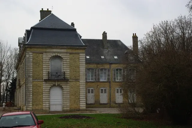
Salperwick Castle, also called Saubruit Castle
No reviews yet
Have you flown here? Share your experience with other pilots.
+ Write the first reviewHistory
Une résidence de campagne des moines de Saint-Bertin est attestée dès le Moyen Age. Au 14e siècle, c'est un domaine agricole d'importance. Un incendie à la fin du 16e siècle amène à la reconstruction des bâtiments et un autre au 18e siècle conduit à nouveau à la reconstruction d'une bonne partie. Vers 1840 ont lieu la démolition des deux pavillons et des travaux sur la façade est. La partie la plus ancienne est située au nord du côté des marais. Il s'agit des communs. Au 18e siècle vient s'accrocher l'aile en T sur la façade nord et deux pavillons calent la composition de la façade sud. La façade sud est agrémentée de décors sobres au 19e siècle. Les intérieurs sont décorés de boiseries et stuccatures qui en font un exemple assez exceptionnel pour la région. On note la forte présence architecturale des communs, en particulier des façades extérieures qui semblent inspirées de l'Italie.
Map and restricted areas
Open in the main mapRestricted zones
Nearby aerodromes
Open aerodromes within 25 km of the spot, heliports included, with their distance and direction from the spot. Near an aerodrome, drone flying is prohibited or height-limited: check the UAS zones map.
| Aerodrome | Type | Distance | Elevation |
|---|---|---|---|
| Saint Omer Wizernes Airfield | Aerodrome | 5.2 km S | 76 m |
| Centre Hospitalier Heliport | Heliport | 8.3 km S | 84 m |
Aviation weather (METAR and TAF)
LFAC – Calais-Dunkerque Airport MVFR
METAR
METAR LFAC 171400Z AUTO 24023G34KT 9999 BKN027/// BKN033/// OVC042/// ///CB 13/10 Q0983
- Wind
- 240°, 43 km/h, gusts 63 km/h
- Visibility
- 10 km or more
- Clouds
- Broken (5-7/8) at 2,700 ft (820 m) ; Broken (5-7/8) at 3,300 ft (1010 m) ; Overcast (8/8) at 4,200 ft (1280 m)
- Temperature
- 13 °C, dew point 10 °C
- QNH
- 983 hPa
- Flight category
- MVFR: ceiling 1,000–3,000 ft or visibility 3–5 mi
TAF
Weather and Kp index
Sunrise and sunset
| Day | Dawn | Sunrise | Golden hour | Sunset | Dusk | Day length |
|---|---|---|---|---|---|---|
| Tue 17 Nov | 07:34 | 08:10 | 08:10–09:03 · 16:09–17:02 | 17:02 | 17:39 | 8 h 52 |
| Wed 18 Nov | 07:35 | 08:12 | 08:12–09:05 · 16:08–17:01 | 17:01 | 17:38 | 8 h 49 |
| Thu 19 Nov | 07:37 | 08:13 | 08:13–09:07 · 16:06–17:00 | 17:00 | 17:36 | 8 h 46 |
| Fri 20 Nov | 07:38 | 08:15 | 08:15–09:09 · 16:05–16:59 | 16:59 | 17:35 | 8 h 43 |
| Sat 21 Nov | 07:39 | 08:16 | 08:16–09:11 · 16:03–16:58 | 16:58 | 17:34 | 8 h 41 |
| Sun 22 Nov | 07:41 | 08:18 | 08:18–09:12 · 16:02–16:57 | 16:57 | 17:34 | 8 h 38 |
| Mon 23 Nov | 07:42 | 08:19 | 08:19–09:14 · 16:01–16:56 | 16:56 | 17:33 | 8 h 36 |


Reviews (0)
Log in to review this spot. Log in · Create a free account
No reviews yet. Share yours!