

Water Mill
No reviews yet
Have you flown here? Share your experience with other pilots.
+ Write the first reviewHistory
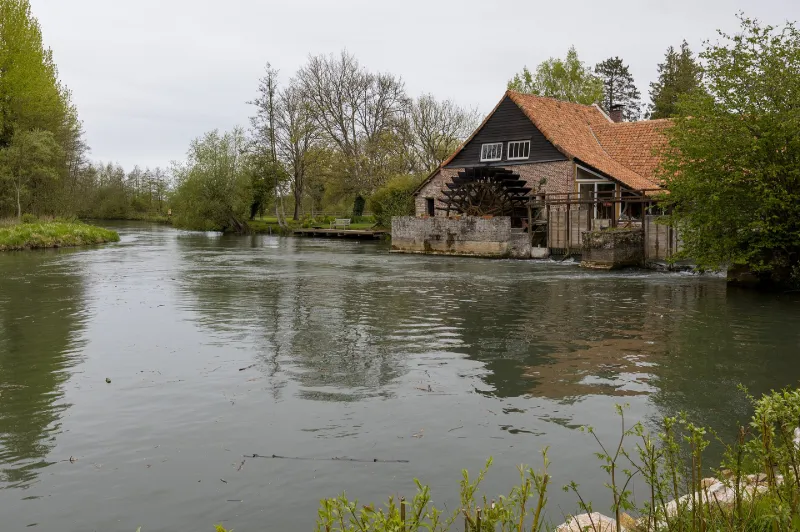
Il s'agit d'un moulin du 12ème siècle situé dans la vallée de l'Authie, près de l'abbaye de Valloires dont il dépendait. Brûlé lors de la Guerre de Cent Ans, il fut probablement reconstruit au cours du 18ème siècle. A la fin du 19ème siècle, il est exploité pour la production de farine et des travaux considérables sont entrepris, notamment, un barrage. La maison du meunier, attenante au moulin, est en torchis chaulé et couverte de tuiles. Le moulin est exploité jusqu'en 1930, date à laquelle il est transformé en moulin à scier le bois avec trois scies. Un bâtiment en pans de bois et torchis élevé perpendiculairement au moulin atteste de cette activité qui cessa en 1975. Durant la décennie 1990, l'ensemble est restauré, un musée est ouvert dans le moulin et une boulangerie artisanale est installée.
Map and restricted areas
Open in the main mapRestricted zones
Nearby aerodromes
Open aerodromes within 25 km of the spot, heliports included, with their distance and direction from the spot. Near an aerodrome, drone flying is prohibited or height-limited: check the UAS zones map.
| Aerodrome | Type | Distance | Elevation |
|---|---|---|---|
| Centre Hospitalier Heliport | Heliport | 12 km NW | 46 m |
| Berck sur Mer Airfield | Aerodrome | 17 km NW | 9 m |
| Centre Hospitalier Heliport | Heliport | 18 km W | 13 m |
| Le Touquet-Côte d'Opale Airport | Airport | 22 km NW | 11 m |
| Abbeville | Airport | 24 km S | 67 m |
Aviation weather (METAR and TAF)
LFAT – Le Touquet-Côte d'Opale Airport IFR
METAR
METAR LFAT 171400Z AUTO 26009KT 210V300 3900 -RA BR FEW015/// BKN028/// BKN047/// ///TCU 12/11 Q0985 TEMPO VRB30G40KT 2500 -TSRAGS OVC014CB
- Wind
- 260°, 17 km/h
- Visibility
- 3.9 km
- Weather
- Rain light ; mist
- Clouds
- Few (1-2/8) at 1,500 ft (460 m) ; Broken (5-7/8) at 2,800 ft (850 m) ; Broken (5-7/8) at 4,700 ft (1430 m)
- Temperature
- 12 °C, dew point 11 °C
- QNH
- 985 hPa
- Flight category
- IFR: ceiling 500–1,000 ft or visibility 1–3 mi
TAF
TAF LFAT 171400Z 1715/1724 25013G23KT 9999 OVC025 TEMPO 1715/1724 VRB20G30KT 4000 SHRA OVC020TCU PROB40 TEMPO 1716/1724 2500 -TSRAGS OVC014CB
| Period (local time) | Change | Wind | Visibility | Weather | Clouds |
|---|---|---|---|---|---|
| 17/11 16:00 → 18/11 01:00 | Initial conditions | 250°, 24 km/h, gusts 43 km/h | 10 km or more | Overcast (8/8) at 2,500 ft (760 m) | |
| 17/11 16:00 → 18/11 01:00 | Temporarily | Variable, 37 km/h, gusts 56 km/h | 4.0 km | Showers of rain | Overcast (8/8) at 2,000 ft (610 m) (towering cumulus) |
| 17/11 17:00 → 18/11 01:00 | Temporarily, probability 40% | 2.5 km | Thunderstorm rain light ; thunderstorm small hail light | Overcast (8/8) at 1,400 ft (430 m) (cumulonimbus) |
Weather and Kp index
Sunrise and sunset
| Day | Dawn | Sunrise | Golden hour | Sunset | Dusk | Day length |
|---|---|---|---|---|---|---|
| Tue 17 Nov | 07:34 | 08:10 | 08:10–09:02 · 16:13–17:05 | 17:05 | 17:41 | 8 h 55 |
| Wed 18 Nov | 07:36 | 08:12 | 08:12–09:04 · 16:12–17:04 | 17:04 | 17:40 | 8 h 52 |
| Thu 19 Nov | 07:37 | 08:13 | 08:13–09:06 · 16:10–17:03 | 17:03 | 17:39 | 8 h 49 |
| Fri 20 Nov | 07:39 | 08:15 | 08:15–09:08 · 16:09–17:02 | 17:02 | 17:38 | 8 h 47 |
| Sat 21 Nov | 07:40 | 08:16 | 08:16–09:10 · 16:07–17:01 | 17:01 | 17:37 | 8 h 44 |
| Sun 22 Nov | 07:41 | 08:18 | 08:18–09:12 · 16:06–17:00 | 17:00 | 17:36 | 8 h 41 |
| Mon 23 Nov | 07:43 | 08:20 | 08:20–09:14 · 16:05–16:59 | 16:59 | 17:36 | 8 h 39 |



Reviews (0)
Log in to review this spot. Log in · Create a free account
No reviews yet. Share yours!