

Kembs-Niffer Lock
No reviews yet
Have you flown here? Share your experience with other pilots.
+ Write the first reviewHistory
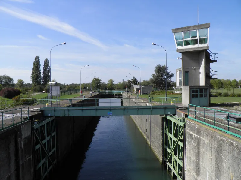
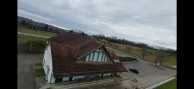
La tour de commande, constituée de béton et de vitres, est supportée par des murs porteurs perpendiculaires sur lesquels s'articule un jeu de pleins et de vides selon les niveaux et de changements d'axes au niveau supérieur. A l'arrière, un escalier indépendant s'enroule de part et d'autre d'un voile de béton menant, au niveau supérieur, au poste de commande où la décoration et le pupitre sont en place. Le bâtiment d'administration comporte le bureau des douaniers et le bureau du service de la navigation, et présente une couverture en forme de paraboloïde hyperbolique. L'accès se fait par une rampe menant à un sous-sol semi-enterré, abritant un vestiaire et des ateliers. Un escalier extérieur mène à l'étage. A ce niveau, la composition spatiale dissymétrique est importante et bien lisible. Du côté sud se trouve le seul élément courbe du bâtiment : le bloc sanitaire.
Map and restricted areas
Open in the main mapRestricted zones
Nearby aerodromes
Open aerodromes within 25 km of the spot, heliports included, with their distance and direction from the spot. Near an aerodrome, drone flying is prohibited or height-limited: check the UAS zones map.
| Aerodrome | Type | Distance | Elevation |
|---|---|---|---|
| Mulhouse-Habsheim Airfield | Aerodrome | 6.8 km NW | 240 m |
| Centre Hospitalier De Moenchsberg Heliport | Heliport | 12 km W | 329 m |
| EuroAirport Basel-Mulhouse-Freiburg Airport | Major airport | 13 km S | 270 m |
| Segelflugplatz Müllheim | Aerodrome | 17 km NE | 291 m |
| Flugplatz Bremgarten | Aerodrome | 24 km N | 212 m |
Aviation weather (METAR and TAF)
LFSB – EuroAirport Basel-Mulhouse-Freiburg Airport VFR
METAR
METAR LFSB 171200Z AUTO 24025G40KT 9999 FEW021 BKN037 OVC046 16/12 Q0995 TEMPO FEW030TCU
- Wind
- 240°, 46 km/h, gusts 74 km/h
- Visibility
- 10 km or more
- Clouds
- Few (1-2/8) at 2,100 ft (640 m) ; Broken (5-7/8) at 3,700 ft (1130 m) ; Overcast (8/8) at 4,600 ft (1400 m)
- Temperature
- 16 °C, dew point 12 °C
- QNH
- 995 hPa
- Flight category
- VFR: ceiling > 3,000 ft and visibility > 5 mi
TAF
TAF LFSB 171100Z 1712/1812 22015G25KT 9999 BKN040 TEMPO 1712/1806 24020G35KT PROB40 TEMPO 1712/1812 -SHRA FEW030TCU PROB40 TEMPO 1712/1715 24025G40KT PROB40 TEMPO 1723/1802 4000 SHRA FEW030CB PROB30 TEMPO 1723/1802 26025G40KT
| Period (local time) | Change | Wind | Visibility | Weather | Clouds |
|---|---|---|---|---|---|
| 17/11 13:00 → 18/11 13:00 | Initial conditions | 220°, 28 km/h, gusts 46 km/h | 10 km or more | Broken (5-7/8) at 4,000 ft (1220 m) | |
| 17/11 13:00 → 18/11 07:00 | Temporarily | 240°, 37 km/h, gusts 65 km/h | |||
| 17/11 13:00 → 18/11 13:00 | Temporarily, probability 40% | Showers of rain light | Few (1-2/8) at 3,000 ft (910 m) (towering cumulus) | ||
| 17/11 13:00 → 17/11 16:00 | Temporarily, probability 40% | 240°, 46 km/h, gusts 74 km/h | |||
| 18/11 00:00 → 18/11 03:00 | Temporarily, probability 40% | 4.0 km | Showers of rain | Few (1-2/8) at 3,000 ft (910 m) (cumulonimbus) | |
| 18/11 00:00 → 18/11 03:00 | Temporarily, probability 30% | 260°, 46 km/h, gusts 74 km/h |
Weather and Kp index
| Day | Weather | Temp. min. / max. | Wind | Rain | Max Kp |
|---|---|---|---|---|---|
| Tue 17 Nov | Partly cloudy | 12° / 16° | 38 km/h SW | 3.1 mm | 5 |
| Wed 18 Nov | Showers | 8° / 12° | 31 km/h SW | 8.3 mm | 5 |
| Thu 19 Nov | Showers | 7° / 12° | 30 km/h SW | 9.1 mm | 3 |
| Fri 20 Nov | Showers | 7° / 10° | 26 km/h SW | 12 mm | 3 |
| Sat 21 Nov | Fair | 6° / 10° | 20 km/h SW | 2.9 mm | – |
| Sun 22 Nov | Rain | 2° / 7° | 17 km/h SE | 13 mm | – |
| Mon 23 Nov | Partly cloudy | 5° / 8° | 21 km/h W | 7.8 mm | – |
Hour by hour: Tuesday 17 November
| Time | Weather | Temp. | Wind | Rain | Clouds | Kp |
|---|---|---|---|---|---|---|
| 13:00 | Partly cloudy | 15° | 33 km/h SW | – | 79 % | 4 |
| 14:00 | Partly cloudy | 16° | 38 km/h SW | – | 52 % | 4 |
| 15:00 | Partly cloudy | 16° | 33 km/h SW | – | 71 % | 4 |
| 16:00 | Partly cloudy | 15° | 30 km/h SW | – | 47 % | 4 |
| 17:00 | Partly cloudy | 14° | 23 km/h SW | – | 59 % | 4 |
| 18:00 | Partly cloudy | 14° | 22 km/h SW | – | 77 % | 4 |
| 19:00 | Partly cloudy | 13° | 18 km/h SW | – | 47 % | 5 |
| 20:00 | Partly cloudy | 12° | 22 km/h S | – | 93 % | 5 |
| 21:00 | Partly cloudy | 13° | 23 km/h SW | – | 66 % | 5 |
| 22:00 | Light rain | 14° | 26 km/h SW | 0.2 mm | 99 % | 5 |
Hour by hour: Wednesday 18 November
| Time | Weather | Temp. | Wind | Rain | Clouds | Kp |
|---|---|---|---|---|---|---|
| 06:00 | Showers | 10° | 27 km/h SW | 0.1 mm | 40 % | 4 |
| 07:00 | Showers | 10° | 27 km/h SW | 0.2 mm | 34 % | 4 |
| 08:00 | Partly cloudy | 10° | 30 km/h SW | – | 46 % | 4 |
| 09:00 | Showers | 10° | 28 km/h SW | 0.2 mm | 67 % | 4 |
| 10:00 | Showers | 11° | 30 km/h SW | 0.1 mm | 83 % | 4 |
| 11:00 | Rain | 12° | 29 km/h SW | 0.6 mm | 94 % | 4 |
| 12:00 | Showers | 11° | 29 km/h SW | 0.9 mm | 77 % | 4 |
| 13:00 | Showers | 11° | 30 km/h SW | 1.3 mm | 71 % | 3 |
| 14:00 | Showers | 11° | 30 km/h SW | 1.3 mm | 79 % | 3 |
| 15:00 | Showers | 10° | 28 km/h SW | 1.0 mm | 82 % | 3 |
| 16:00 | Showers | 10° | 30 km/h SW | 0.3 mm | 83 % | 3 |
| 17:00 | Showers | 9° | 26 km/h SW | 0.3 mm | 56 % | 3 |
| 18:00 | Showers | 9° | 23 km/h SW | 0.1 mm | 80 % | 3 |
| 19:00 | Showers | 9° | 22 km/h SW | 0.4 mm | 44 % | 2 |
| 20:00 | Showers | 9° | 23 km/h SW | 0.2 mm | 54 % | 2 |
| 21:00 | Partly cloudy | 9° | 21 km/h SW | – | 80 % | 2 |
| 22:00 | Partly cloudy | 8° | 19 km/h SW | – | 61 % | 2 |
Sunrise and sunset
| Day | Dawn | Sunrise | Golden hour | Sunset | Dusk | Day length |
|---|---|---|---|---|---|---|
| Tue 17 Nov | 07:05 | 07:38 | 07:38–08:27 · 16:03–16:52 | 16:52 | 17:25 | 9 h 13 |
| Wed 18 Nov | 07:06 | 07:40 | 07:40–08:28 · 16:02–16:50 | 16:50 | 17:24 | 9 h 10 |
| Thu 19 Nov | 07:07 | 07:41 | 07:41–08:30 · 16:01–16:49 | 16:49 | 17:23 | 9 h 08 |
| Fri 20 Nov | 07:09 | 07:43 | 07:43–08:32 · 15:59–16:48 | 16:48 | 17:23 | 9 h 05 |
| Sat 21 Nov | 07:10 | 07:44 | 07:44–08:33 · 15:58–16:48 | 16:48 | 17:22 | 9 h 03 |
| Sun 22 Nov | 07:11 | 07:46 | 07:46–08:35 · 15:57–16:47 | 16:47 | 17:21 | 9 h 01 |
| Mon 23 Nov | 07:13 | 07:47 | 07:47–08:37 · 15:56–16:46 | 16:46 | 17:20 | 8 h 58 |
Reviews (0)
Log in to review this spot. Log in · Create a free account
No reviews yet. Share yours!