

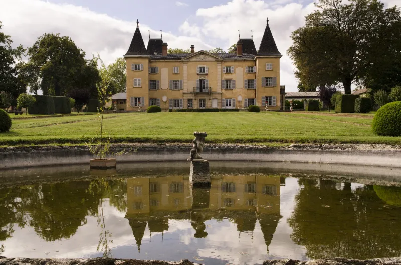
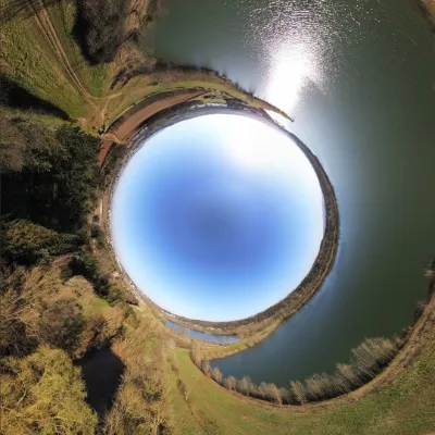
Vaurenard Estate
No reviews yet
Have you flown here? Share your experience with other pilots.
+ Write the first reviewHistory
Le domaine servait sans doute, à l'origine, de rendez-vous de chasse aux sires de Beaujeu. D'importants travaux sont réalisés au 17e (création d'une pièce d'eau, changement d'orientation du corps de logis) et 18e siècle (aménagement de la cour avec la grille d'entrée, aménagements intérieurs). En 1903, le château est réaménagé par Michel et Paul de Montclos avec rehaussement du corps de logis principal, redistribution des pièces du rez-de-chaussée, création d'un vestibule et de son escalier d'apparat, aménagement d'un chartrier. En 1913 est créé un jardin à la française par le paysagiste Linossier. £Le corps de logis adopte un plan en U. La façade donnant sur le jardin est flanquée de pavillons aux angles sud et nord. Le pavillon sud est la partie la plus ancienne. La façade sud sur jardin est traversée par un passage voûté, accès antérieur du château. Les corps de bâtiment en retour d'équerre du château sont bornés par deux pavillons qui marquent la liaison au nord, avec le premier bâtiment de communs, au sud avec la chapelle. Le décor du château a été remanié au début du 20e siècle selon le style Louis XVI (toile peinte, boiseries, tapisseries, papier peint). Terminée en 1848, la chapelle est de style néo gothique. Les communs sont situés à l'ouest du château et forment deux groupes de bâtiments formant deux cours. Le parc est un domaine agricole, viticole et ornemental. Au début du 20e siècle, le parc paysager est transformé en une structure mixte réalisée par Joseph Linossier. £
Map and restricted areas
Open in the main mapRestricted zones
| Zone | Category | Limits | Conditions |
|---|---|---|---|
| Villefranche | Zone réglementée | 1372 m above sea level → 2297 m above sea level | Vols interdits sauf lorsque the official document of the zone l'autorise explicitement ou avec l'accord du gestionnaire de la zone lorsqu'il est désigné par the official document of the zone |
Nearby aerodromes
Open aerodromes within 25 km of the spot, heliports included, with their distance and direction from the spot. Near an aerodrome, drone flying is prohibited or height-limited: check the UAS zones map.
| Aerodrome | Type | Distance | Elevation |
|---|---|---|---|
| Centre Hospitalier Heliport | Heliport | 1.4 km N | 233 m |
| Villefranche-Tarare Airport | Aerodrome | 9.5 km SW | 328 m |
| Château De Pézay Heliport | Heliport | 16 km N | 233 m |
| Belleville Villié Morgon Airfield | Aerodrome | 17 km N | 215 m |
Aviation weather (METAR and TAF)
LFLY – Lyon-Bron Airport VFR
METAR
METAR LFLY 171400Z AUTO 17016KT CAVOK 16/11 Q1001
- Wind
- 170°, 30 km/h
- Visibility
- 10 km or more
- Clouds
- –
- Temperature
- 16 °C, dew point 11 °C
- QNH
- 1001 hPa
- Flight category
- VFR: ceiling > 3,000 ft and visibility > 5 mi
TAF
TAF LFLY 170500Z 1706/1806 18015G25KT CAVOK TEMPO 1706/1712 18020G35KT 4500 RA FEW050TCU OVC055 BECMG 1800/1803 20012KT TEMPO 1800/1803 32015G25KT 4000 SHRA BKN045TCU
| Period (local time) | Change | Wind | Visibility | Weather | Clouds |
|---|---|---|---|---|---|
| 17/11 07:00 → 18/11 01:00 | Initial conditions | 180°, 28 km/h, gusts 46 km/h | 10 km or more | No significant weather | No significant cloud |
| 17/11 07:00 → 17/11 13:00 | Temporarily | 180°, 37 km/h, gusts 65 km/h | 4.5 km | Rain | Few (1-2/8) at 5,000 ft (1520 m) (towering cumulus) ; Overcast (8/8) at 5,500 ft (1680 m) |
| 18/11 01:00 → 18/11 07:00 | Becoming | 200°, 22 km/h | 10 km or more | No significant weather | No significant cloud |
| 18/11 01:00 → 18/11 04:00 | Temporarily | 320°, 28 km/h, gusts 46 km/h | 4.0 km | Showers of rain | Broken (5-7/8) at 4,500 ft (1370 m) (towering cumulus) |
Weather and Kp index
Sunrise and sunset
| Day | Dawn | Sunrise | Golden hour | Sunset | Dusk | Day length |
|---|---|---|---|---|---|---|
| Tue 17 Nov | 07:12 | 07:44 | 07:44–08:31 · 16:22–17:08 | 17:08 | 17:40 | 9 h 23 |
| Wed 18 Nov | 07:13 | 07:46 | 07:46–08:32 · 16:21–17:07 | 17:07 | 17:40 | 9 h 21 |
| Thu 19 Nov | 07:14 | 07:47 | 07:47–08:34 · 16:19–17:06 | 17:06 | 17:39 | 9 h 18 |
| Fri 20 Nov | 07:16 | 07:49 | 07:49–08:35 · 16:18–17:05 | 17:05 | 17:38 | 9 h 16 |
| Sat 21 Nov | 07:17 | 07:50 | 07:50–08:37 · 16:17–17:04 | 17:04 | 17:37 | 9 h 14 |
| Sun 22 Nov | 07:18 | 07:51 | 07:51–08:38 · 16:16–17:03 | 17:03 | 17:36 | 9 h 12 |
| Mon 23 Nov | 07:19 | 07:53 | 07:53–08:40 · 16:15–17:03 | 17:03 | 17:36 | 9 h 10 |
Reviews (0)
Log in to review this spot. Log in · Create a free account
No reviews yet. Share yours!