

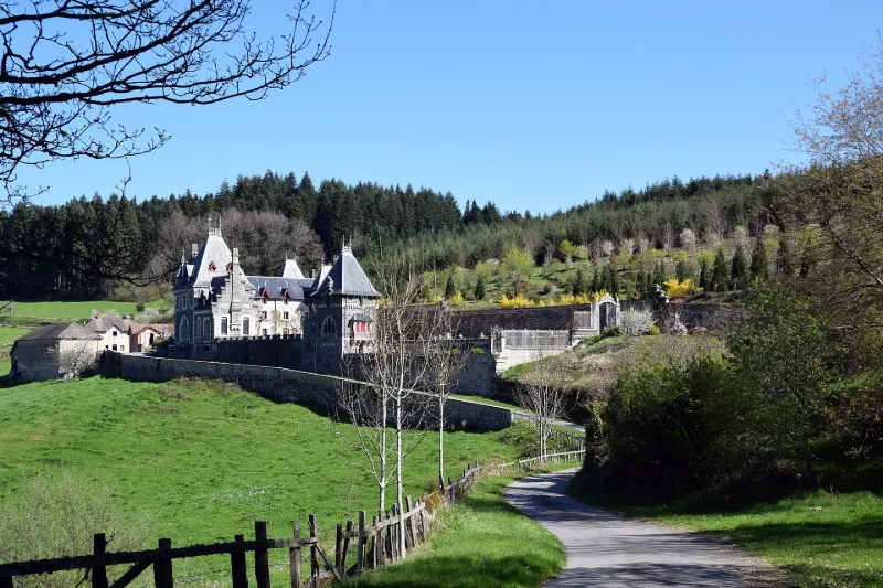
Residence known as Cros Castle
No reviews yet
Have you flown here? Share your experience with other pilots.
+ Write the first reviewHistory
Le "château de Cros" ne prend le titre de "château" que très tardivement, dans la seconde moitié du XIXe siècle quand la famille Vacheron entreprend des modifications sur un ancien domaine fermier pour en faire une résidence secondaire de luxe. Le domaine fut construit en deux temps au sein d'un petit domaine agricole dont les bâtiments apparaissent clairement sur le cadastre napoléonien. Julien Richard-Vitton (1838-1919) fut capitaine des gardes mobiles pendant la guerre de 1870, conseiller général du Rhône et maire d'Azolette. Durant la guerre, celle qui devait devenir son épouse, Catherine Vacheron aurait été des premières infirmières militaires. On ne connait pas à Julien d'activité particulière après son service. La vie du couple semble cependant avoir été rythmée par les réceptions de Madame, fort peu du goût de Monsieur qui se réfugiait dans son pavillon. Le domaine fut construit vers 1899 sous la direction de Catherine et en maîtrise d'œuvre conjointement par l'architecte Jean Burel et l'ingénieur Louis Lombard ou Louis Lombard-Gérin. Jean Burel est cité à plusieurs reprises dans la revue La Construction lyonnaise comme architecte de la Compagnie du Gaz. La Construction lyonnaise nous apprend à l'occasion de la remise de la médaille d'argent à Jules Saint-Sorny, chef serrurier chez Brunard, que cet ouvrier hautement qualifié a travaillé sous les ordres de plusieurs architectes dont Burel. Louis Lombard-Gerin (1848-1918) était ingénieur électricien, il déposa un brevet du trolley automoteur en 1900.
Map and restricted areas
Open in the main mapRestricted zones
Nearby aerodromes
Open aerodromes within 25 km of the spot, heliports included, with their distance and direction from the spot. Near an aerodrome, drone flying is prohibited or height-limited: check the UAS zones map.
| Aerodrome | Type | Distance | Elevation |
|---|---|---|---|
| Château De Pézay Heliport | Heliport | 23 km E | 233 m |
| Belleville Villié Morgon Airfield | Aerodrome | 23 km E | 215 m |
Aviation weather (METAR and TAF)
LFLN – Saint-Yan Airport VFR
METAR
METAR LFLN 171400Z AUTO 24006KT 200V280 CAVOK 17/10 Q0999 TEMPO FEW030TCU
- Wind
- 240°, 11 km/h
- Visibility
- 10 km or more
- Clouds
- –
- Temperature
- 17 °C, dew point 10 °C
- QNH
- 999 hPa
- Flight category
- VFR: ceiling > 3,000 ft and visibility > 5 mi
TAF
TAF LFLN 171400Z 1715/1724 24012KT CAVOK TEMPO 1719/1724 22020G30KT -SHRA FEW040TCU PROB40 TEMPO 1722/1724 23025G40KT SHRA FEW035CB
| Period (local time) | Change | Wind | Visibility | Weather | Clouds |
|---|---|---|---|---|---|
| 17/11 16:00 → 18/11 01:00 | Initial conditions | 240°, 22 km/h | 10 km or more | No significant weather | No significant cloud |
| 17/11 20:00 → 18/11 01:00 | Temporarily | 220°, 37 km/h, gusts 56 km/h | Showers of rain light | Few (1-2/8) at 4,000 ft (1220 m) (towering cumulus) | |
| 17/11 23:00 → 18/11 01:00 | Temporarily, probability 40% | 230°, 46 km/h, gusts 74 km/h | Showers of rain | Few (1-2/8) at 3,500 ft (1070 m) (cumulonimbus) |
Weather and Kp index
Sunrise and sunset
| Day | Dawn | Sunrise | Golden hour | Sunset | Dusk | Day length |
|---|---|---|---|---|---|---|
| Tue 17 Nov | 07:13 | 07:46 | 07:46–08:33 · 16:22–17:08 | 17:08 | 17:41 | 9 h 22 |
| Wed 18 Nov | 07:15 | 07:47 | 07:47–08:34 · 16:21–17:07 | 17:07 | 17:40 | 9 h 19 |
| Thu 19 Nov | 07:16 | 07:49 | 07:49–08:36 · 16:20–17:06 | 17:06 | 17:39 | 9 h 17 |
| Fri 20 Nov | 07:17 | 07:50 | 07:50–08:37 · 16:19–17:06 | 17:06 | 17:39 | 9 h 15 |
| Sat 21 Nov | 07:19 | 07:52 | 07:52–08:39 · 16:18–17:05 | 17:05 | 17:38 | 9 h 13 |
| Sun 22 Nov | 07:20 | 07:53 | 07:53–08:40 · 16:17–17:04 | 17:04 | 17:37 | 9 h 10 |
| Mon 23 Nov | 07:21 | 07:54 | 07:54–08:42 · 16:16–17:03 | 17:03 | 17:36 | 9 h 08 |


Reviews (0)
Log in to review this spot. Log in · Create a free account
No reviews yet. Share yours!