

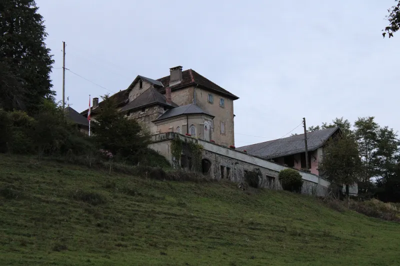
Mieudry Fortified House
No reviews yet
Have you flown here? Share your experience with other pilots.
+ Write the first reviewHistory
Il s'agit d'un exemple rare de maison-forte conservée en Haute-Savoie. Elle est représentative de l'évolution d'une architecture castrale vers une architecture de villégiature bourgeoise au 19e siècle : une maison de maître accompagnée de sa chapelle à proximité de bâtiments destinés à l'exploitation agricole. L'aspect général de l'édifice actuel est l'aboutissement des dernières campagnes de travaux de modernisation au 19e siècle mais les différentes époques de construction se découvrent tant en plan qu'en élévation.
Map and restricted areas
Open in the main mapRestricted zones
| Zone | Category | Limits | Conditions |
|---|---|---|---|
| Ctr Annecy |
Zone de contrôle civile | 50 m above ground level → 1219 m above sea level | Flights above 50 metres are forbidden without the prior agreement of air traffic control |
| Zrt/zdt Riviera | ZRT/ZDT | From about 14,950 m to about 16,750 m above sea level | SUP AIP 233/24 · Du 16 janvier 2025 au 13 janvier 2027 |
Nearby aerodromes
Open aerodromes within 25 km of the spot, heliports included, with their distance and direction from the spot. Near an aerodrome, drone flying is prohibited or height-limited: check the UAS zones map.
| Aerodrome | Type | Distance | Elevation |
|---|---|---|---|
| Centre Hospitalier Heliport | Heliport | 12 km E | 485 m |
| Annecy-Haute-Savoie-Mont Blanc Airport | Airport | 12 km NE | 464 m |
| Base Hydro-ULM Rhône Lavours | Seaplane base | 16 km W | 239 m |
| Corbonod-Seyssel Private | Aerodrome | 17 km NW | 358 m |
| Grand Colombier Heliport | Heliport | 17 km W | 1,437 m |
Aviation weather (METAR and TAF)
LFLP – Annecy-Haute-Savoie-Mont Blanc Airport VFR
METAR
METAR LFLP 171230Z AUTO 31004KT 260V330 9999 BKN049 OVC064 13/11 Q1003
- Wind
- 310°, 7 km/h
- Visibility
- 10 km or more
- Clouds
- Broken (5-7/8) at 4,900 ft (1490 m) ; Overcast (8/8) at 6,400 ft (1950 m)
- Temperature
- 13 °C, dew point 11 °C
- QNH
- 1003 hPa
- Flight category
- VFR: ceiling > 3,000 ft and visibility > 5 mi
TAF
TAF LFLP 170200Z 1703/1803 VRB03KT CAVOK TEMPO 1703/1705 -RA OVC050 BECMG 1707/1709 22008KT -RA OVC050 TEMPO 1709/1721 4000 RA BKN020 FM172100 22012KT CAVOK TEMPO 1723/1803 VRB18G30KT 4000 SHRA BKN050TCU
| Period (local time) | Change | Wind | Visibility | Weather | Clouds |
|---|---|---|---|---|---|
| 17/11 04:00 → 17/11 08:00 | Initial conditions | Variable, 6 km/h | 10 km or more | No significant weather | No significant cloud |
| 17/11 04:00 → 17/11 06:00 | Temporarily | Rain light | Overcast (8/8) at 5,000 ft (1520 m) | ||
| 17/11 08:00 → 17/11 22:00 | Becoming | 220°, 15 km/h | 10 km or more | Rain light | Overcast (8/8) at 5,000 ft (1520 m) |
| 17/11 10:00 → 17/11 22:00 | Temporarily | 4.0 km | Rain | Broken (5-7/8) at 2,000 ft (610 m) | |
| 17/11 22:00 → 18/11 04:00 | From | 220°, 22 km/h | 10 km or more | No significant weather | No significant cloud |
| 18/11 00:00 → 18/11 04:00 | Temporarily | Variable, 33 km/h, gusts 56 km/h | 4.0 km | Showers of rain | Broken (5-7/8) at 5,000 ft (1520 m) (towering cumulus) |
Weather and Kp index
| Day | Weather | Temp. min. / max. | Wind | Rain | Max Kp |
|---|---|---|---|---|---|
| Tue 17 Nov | Light rain | 8° / 13° | 17 km/h S | 0.9 mm | 5 |
| Wed 18 Nov | Showers | 7° / 12° | 21 km/h S | 13 mm | 5 |
| Thu 19 Nov | Showers | 6° / 10° | 17 km/h S | 29 mm | 3 |
| Fri 20 Nov | Rain | 5° / 9° | 15 km/h SE | 21 mm | 3 |
| Sat 21 Nov | Clear sky | 4° / 12° | 9 km/h SE | 3.2 mm | – |
| Sun 22 Nov | Showers | 4° / 9° | 5 km/h E | 19 mm | – |
| Mon 23 Nov | Fair | 4° / 10° | 13 km/h SE | 0.3 mm | – |
Hour by hour: Tuesday 17 November
| Time | Weather | Temp. | Wind | Rain | Clouds | Kp |
|---|---|---|---|---|---|---|
| 13:00 | Light rain | 11° | 14 km/h SE | 0.1 mm | 95 % | 4 |
| 14:00 | Partly cloudy | 12° | 12 km/h S | – | 74 % | 4 |
| 15:00 | Fair | 13° | 13 km/h SE | – | 26 % | 4 |
| 16:00 | Clear sky | 13° | 12 km/h SE | – | 12 % | 4 |
| 17:00 | Clear sky | 11° | 10 km/h SE | – | 4 % | 4 |
| 18:00 | Clear sky | 9° | 8 km/h S | – | 0 % | 4 |
| 19:00 | Fair | 8° | 10 km/h S | – | 13 % | 5 |
| 20:00 | Fair | 9° | 13 km/h S | – | 38 % | 5 |
| 21:00 | Partly cloudy | 9° | 13 km/h S | – | 74 % | 5 |
| 22:00 | Light rain | 10° | 13 km/h S | 0.2 mm | 93 % | 5 |
Hour by hour: Wednesday 18 November
| Time | Weather | Temp. | Wind | Rain | Clouds | Kp |
|---|---|---|---|---|---|---|
| 06:00 | Showers | 10° | 18 km/h S | 0.2 mm | 60 % | 4 |
| 07:00 | Showers | 9° | 15 km/h S | 0.2 mm | 59 % | 4 |
| 08:00 | Showers | 9° | 14 km/h S | 0.2 mm | 46 % | 4 |
| 09:00 | Showers | 10° | 15 km/h S | 0.2 mm | 42 % | 4 |
| 10:00 | Fair | 10° | 14 km/h S | – | 25 % | 4 |
| 11:00 | Light rain | 11° | 17 km/h S | 0.2 mm | 88 % | 4 |
| 12:00 | Showers | 12° | 15 km/h SW | 0.1 mm | 20 % | 4 |
| 13:00 | Showers | 11° | 21 km/h S | 0.4 mm | 55 % | 3 |
| 14:00 | Showers | 11° | 17 km/h S | 0.2 mm | 55 % | 3 |
| 15:00 | Cloudy | 12° | 14 km/h SW | – | 89 % | 3 |
| 16:00 | Rain | 11° | 17 km/h S | 0.7 mm | 99 % | 3 |
| 17:00 | Rain | 10° | 17 km/h S | 0.8 mm | 98 % | 3 |
| 18:00 | Rain | 9° | 14 km/h S | 0.5 mm | 100 % | 3 |
| 19:00 | Rain | 9° | 15 km/h SE | 0.4 mm | 100 % | 2 |
| 20:00 | Light rain | 9° | 10 km/h SE | 0.2 mm | 98 % | 2 |
| 21:00 | Light rain | 8° | 13 km/h SE | 0.2 mm | 100 % | 2 |
| 22:00 | Light rain | 8° | 14 km/h SE | 0.2 mm | 100 % | 2 |
Sunrise and sunset
| Day | Dawn | Sunrise | Golden hour | Sunset | Dusk | Day length |
|---|---|---|---|---|---|---|
| Tue 17 Nov | 07:06 | 07:39 | 07:39–08:25 · 16:17–17:03 | 17:03 | 17:36 | 9 h 24 |
| Wed 18 Nov | 07:08 | 07:40 | 07:40–08:26 · 16:16–17:02 | 17:02 | 17:35 | 9 h 21 |
| Thu 19 Nov | 07:09 | 07:42 | 07:42–08:28 · 16:15–17:01 | 17:01 | 17:34 | 9 h 19 |
| Fri 20 Nov | 07:10 | 07:43 | 07:43–08:30 · 16:14–17:00 | 17:00 | 17:33 | 9 h 17 |
| Sat 21 Nov | 07:12 | 07:44 | 07:44–08:31 · 16:13–17:00 | 17:00 | 17:32 | 9 h 15 |
| Sun 22 Nov | 07:13 | 07:46 | 07:46–08:33 · 16:12–16:59 | 16:59 | 17:32 | 9 h 13 |
| Mon 23 Nov | 07:14 | 07:47 | 07:47–08:34 · 16:11–16:58 | 16:58 | 17:31 | 9 h 11 |

Reviews (0)
Log in to review this spot. Log in · Create a free account
No reviews yet. Share yours!