

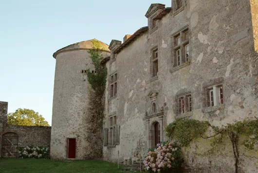
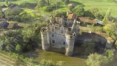
Puy Blain Manor
No reviews yet
Have you flown here? Share your experience with other pilots.
+ Write the first reviewHistory
Le logis actuel a été bâti en 1589. Ce dernier forme avec les dépendances une cour rectangulaire entourée de murs et défendue par un bastion au sud-est. L'entrée s'effectue au sud par un porche en plein cintre accompagné d'une porte piétonne surmontée d'un crénelage décoratif. Du logis médiéval subsiste, au nord-ouest, une pièce munie d'une travée de cheminées rustiques du 15e siècle. Le logis du 16e siècle est accolé d'une grosse tour cylindrique à l'angle sud-est. La porte d'entrée en plein cintre est encadrée de pilastres ornés d'oves et son fronton surélevé est percé d'un oeil de boeuf. Puy-Blain est caractéristique de ces petits domaines de la fin du Moyen Age, mi seigneuriaux, mi agricoles, nombreux en Deux-Sèvres. Il présente à la fois des éléments défensifs (tour, bastion, bouche à feu) et des éléments résidentiels.
Map and restricted areas
Open in the main mapRestricted zones
| Zone | Category | Limits | Conditions |
|---|---|---|---|
| Cognac | Zone réglementée | 2748 m above sea level → 6259 m above sea level | Vols interdits sauf lorsque the official document of the zone l'autorise explicitement ou avec l'accord du gestionnaire de la zone lorsqu'il est désigné par the official document of the zone |
| TRA90NL | TRA | FL 195 / FL 275 | SUP AIP AIRAC 023/26 · Du jeudi 19 mars 2026 au mercredi 17 mars 2027 |
| TRA90NH | TRA | FL 305 / FL 335 | SUP AIP AIRAC 023/26 · Du jeudi 19 mars 2026 au mercredi 17 mars 2027 |
Nearby aerodromes
Open aerodromes within 25 km of the spot, heliports included, with their distance and direction from the spot. Near an aerodrome, drone flying is prohibited or height-limited: check the UAS zones map.
| Aerodrome | Type | Distance | Elevation |
|---|---|---|---|
| Mauléon Airport | Aerodrome | 16 km NW | 176 m |
Aviation weather (METAR and TAF)
No METAR station within 50 km.
Weather and Kp index
Sunrise and sunset
| Day | Dawn | Sunrise | Golden hour | Sunset | Dusk | Day length |
|---|---|---|---|---|---|---|
| Tue 17 Nov | 07:35 | 08:08 | 08:08–08:55 · 16:39–17:26 | 17:26 | 17:59 | 9 h 18 |
| Wed 18 Nov | 07:36 | 08:09 | 08:09–08:57 · 16:38–17:25 | 17:25 | 17:58 | 9 h 16 |
| Thu 19 Nov | 07:37 | 08:11 | 08:11–08:58 · 16:37–17:24 | 17:24 | 17:58 | 9 h 13 |
| Fri 20 Nov | 07:39 | 08:12 | 08:12–09:00 · 16:36–17:23 | 17:23 | 17:57 | 9 h 11 |
| Sat 21 Nov | 07:40 | 08:13 | 08:13–09:01 · 16:35–17:23 | 17:23 | 17:56 | 9 h 09 |
| Sun 22 Nov | 07:41 | 08:15 | 08:15–09:03 · 16:33–17:22 | 17:22 | 17:55 | 9 h 06 |
| Mon 23 Nov | 07:42 | 08:16 | 08:16–09:05 · 16:32–17:21 | 17:21 | 17:55 | 9 h 04 |
Reviews (0)
Log in to review this spot. Log in · Create a free account
No reviews yet. Share yours!