

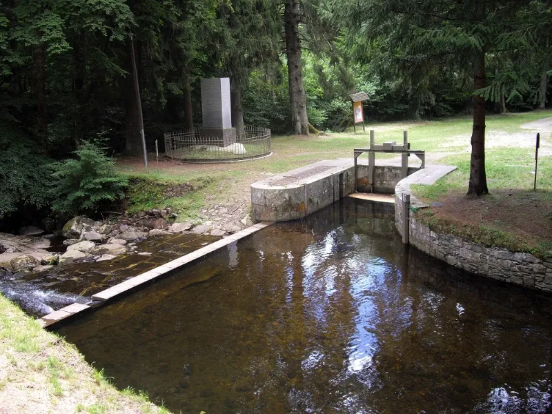
Canal du Midi: Alzau Water Intake
No reviews yet
Have you flown here? Share your experience with other pilots.
+ Write the first reviewHistory
Le canal du Languedoc ou canal de communication des Deux Mers a été réalisé sous Louis XIV d'après les plans de l'ingénieur Pierre-Paul Riquet, communiqués à Colbert en 1662. Les travaux commencent en 1667 par la partie du canal située entre Toulouse et Naurouse. En 1672, la première partie du canal est terminée. Après quelques rectifications, le canal est définitivement achevé à la fin de l'année 1682. Prise d'eau placée à la tête de la rigole de la Montagne Noire, elle est considérée comme la source de la jonction des mers. Ouvrage primitif du 17e siècle, ayant subi des modifications. Le site a toujours été un haut lieu du canal
Map and restricted areas
Open in the main mapRestricted zones
| Zone | Category | Limits | Conditions |
|---|---|---|---|
| Tma Toulouse |
Région de contrôle terminal | 457 m above ground level → 2297 m above sea level · 610 m above sea level → 914 m above sea level · 610 m above sea level → 2297 m above sea level · 732 m above sea level → 914 m above sea level · 762 m above sea level → 2297 m above sea level · 914 m above sea level → 1219 m above sea level · 914 m above sea level → 1219 m above sea level · 914 m above sea level → 2297 m above sea level · 914 m above sea level → 2297 m above sea level · 914 m above sea level → 2297 m above sea level · 1067 m above sea level → 2297 m above sea level · 1067 m above sea level → 3821 m above sea level · 1219 m above sea level → 2297 m above sea level · 1219 m above sea level → 2297 m above sea level · 1219 m above sea level → 2297 m above sea level · 1529 m above sea level → 3821 m above sea level · 1529 m above sea level → 3821 m above sea level · 1529 m above sea level → 3821 m above sea level | Drone flights inside this zone are forbidden without the prior agreement of air traffic control |
| Istres | Zone réglementée | 5491 m above sea level → 30766 m above sea level | Vols interdits sauf lorsque the official document of the zone l'autorise explicitement ou avec l'accord du gestionnaire de la zone lorsqu'il est désigné par the official document of the zone |
Nearby aerodromes
Open aerodromes within 25 km of the spot, heliports included, with their distance and direction from the spot. Near an aerodrome, drone flying is prohibited or height-limited: check the UAS zones map.
| Aerodrome | Type | Distance | Elevation |
|---|---|---|---|
| Castres-Mazamet Airport | Airport | 19 km N | 240 m |
| Aérodrome de la Montagne Noire | Aerodrome | 19 km W | 448 m |
| Carcassonne Airport | Airport | 21 km S | 132 m |
| Revel Montgey Airfield | Aerodrome | 22 km NW | 196 m |
| Centre Hospitalier Heliport | Heliport | 23 km N | 196 m |
Aviation weather (METAR and TAF)
LFCK – Castres-Mazamet Airport VFR
METAR
METAR LFCK 171330Z AUTO 08006KT 020V110 9999 FEW038 SCT100 BKN120 15/13 Q1005 TEMPO VRB15G25KT 4000 SHRA BKN018 BKN040TCU FEW070CB
- Wind
- 080°, 11 km/h
- Visibility
- 10 km or more
- Clouds
- Few (1-2/8) at 3,800 ft (1160 m) ; Scattered (3-4/8) at 10,000 ft (3050 m) ; Broken (5-7/8) at 12,000 ft (3660 m)
- Temperature
- 15 °C, dew point 13 °C
- QNH
- 1005 hPa
- Flight category
- VFR: ceiling > 3,000 ft and visibility > 5 mi
TAF
TAF LFCK 171100Z 1712/1721 12004KT CAVOK TEMPO 1712/1721 VRB15G25KT 4000 SHRA BKN018 BKN040TCU FEW070CB
| Period (local time) | Change | Wind | Visibility | Weather | Clouds |
|---|---|---|---|---|---|
| 17/11 13:00 → 17/11 22:00 | Initial conditions | 120°, 7 km/h | 10 km or more | No significant weather | No significant cloud |
| 17/11 13:00 → 17/11 22:00 | Temporarily | Variable, 28 km/h, gusts 46 km/h | 4.0 km | Showers of rain | Broken (5-7/8) at 1,800 ft (550 m) ; Broken (5-7/8) at 4,000 ft (1220 m) (towering cumulus) ; Few (1-2/8) at 7,000 ft (2130 m) (cumulonimbus) |
Weather and Kp index
| Day | Weather | Temp. min. / max. | Wind | Rain | Max Kp |
|---|---|---|---|---|---|
| Tue 17 Nov | Light rain | 9° / 11° | 9 km/h NE | 2.6 mm | 5 |
| Wed 18 Nov | Fair | 8° / 12° | 26 km/h SE | 5.9 mm | 5 |
| Thu 19 Nov | Fair | 7° / 11° | 31 km/h W | 13 mm | 3 |
| Fri 20 Nov | Fair | 6° / 11° | 20 km/h NW | 0.5 mm | 3 |
| Sat 21 Nov | Cloudy | 7° / 13° | 17 km/h SE | – | – |
| Sun 22 Nov | Showers | 7° / 9° | 23 km/h W | 2.9 mm | – |
| Mon 23 Nov | Cloudy | 5° / 11° | 17 km/h NW | – | – |
Hour by hour: Tuesday 17 November
| Time | Weather | Temp. | Wind | Rain | Clouds | Kp |
|---|---|---|---|---|---|---|
| 15:00 | Light rain | 11° | 6 km/h N | 0.1 mm | 100 % | 4 |
| 16:00 | Cloudy | 11° | 6 km/h N | – | 99 % | 4 |
| 17:00 | Light rain | 11° | 9 km/h NE | 0.2 mm | 100 % | 4 |
| 18:00 | Light rain | 10° | 7 km/h NE | 0.2 mm | 100 % | 4 |
| 19:00 | Cloudy | 9° | 6 km/h E | – | 97 % | 5 |
| 20:00 | Light rain | 9° | 8 km/h N | 0.3 mm | 99 % | 5 |
| 21:00 | Rain | 9° | 9 km/h NE | 1.0 mm | 100 % | 5 |
| 22:00 | Rain | 9° | 6 km/h NE | 0.8 mm | 99 % | 5 |
Hour by hour: Wednesday 18 November
| Time | Weather | Temp. | Wind | Rain | Clouds | Kp |
|---|---|---|---|---|---|---|
| 06:00 | Rain | 11° | 23 km/h NW | 0.5 mm | 100 % | 4 |
| 07:00 | Heavy rain | 10° | 19 km/h NW | 1.4 mm | 100 % | 4 |
| 08:00 | Heavy rain | 10° | 20 km/h NW | 1.7 mm | 100 % | 4 |
| 09:00 | Rain | 9° | 19 km/h W | 0.9 mm | 100 % | 4 |
| 10:00 | Cloudy | 9° | 18 km/h W | – | 100 % | 4 |
| 11:00 | Cloudy | 9° | 18 km/h W | – | 100 % | 4 |
| 12:00 | Partly cloudy | 10° | 14 km/h W | – | 66 % | 4 |
| 13:00 | Fair | 11° | 18 km/h W | – | 35 % | 3 |
| 14:00 | Fair | 12° | 18 km/h W | – | 21 % | 3 |
| 15:00 | Fair | 12° | 18 km/h W | – | 33 % | 3 |
| 16:00 | Fair | 12° | 15 km/h W | – | 38 % | 3 |
| 17:00 | Partly cloudy | 10° | 10 km/h NW | – | 60 % | 3 |
| 18:00 | Partly cloudy | 9° | 5 km/h NW | – | 70 % | 3 |
| 19:00 | Partly cloudy | 9° | 5 km/h NE | – | 86 % | 2 |
| 20:00 | Partly cloudy | 8° | 7 km/h E | – | 73 % | 2 |
| 21:00 | Cloudy | 9° | 15 km/h E | – | 98 % | 2 |
| 22:00 | Cloudy | 11° | 21 km/h SE | – | 100 % | 2 |
Sunrise and sunset
| Day | Dawn | Sunrise | Golden hour | Sunset | Dusk | Day length |
|---|---|---|---|---|---|---|
| Tue 17 Nov | 07:16 | 07:47 | 07:47–08:30 · 16:42–17:25 | 17:25 | 17:56 | 9 h 38 |
| Wed 18 Nov | 07:17 | 07:48 | 07:48–08:32 · 16:41–17:24 | 17:24 | 17:55 | 9 h 35 |
| Thu 19 Nov | 07:19 | 07:50 | 07:50–08:33 · 16:40–17:23 | 17:23 | 17:54 | 9 h 33 |
| Fri 20 Nov | 07:20 | 07:51 | 07:51–08:35 · 16:39–17:23 | 17:23 | 17:54 | 9 h 31 |
| Sat 21 Nov | 07:21 | 07:52 | 07:52–08:36 · 16:38–17:22 | 17:22 | 17:53 | 9 h 29 |
| Sun 22 Nov | 07:22 | 07:53 | 07:53–08:37 · 16:37–17:21 | 17:21 | 17:52 | 9 h 27 |
| Mon 23 Nov | 07:23 | 07:54 | 07:54–08:39 · 16:36–17:20 | 17:20 | 17:52 | 9 h 25 |

Reviews (0)
Log in to review this spot. Log in · Create a free account
No reviews yet. Share yours!