

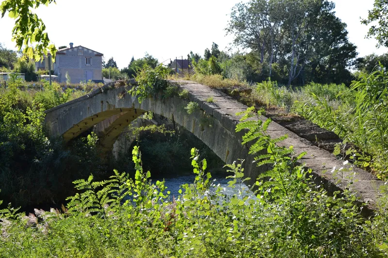
Canaù Aqueduct Bridge, engineering structure of the Saint-Julien Canal over the Coulon River, located in the Entre-Deux-Vallats district
No reviews yet
Have you flown here? Share your experience with other pilots.
+ Write the first reviewHistory
Situé à moins de deux kilomètres au nord de Cavaillon, le pont-aqueduc de la Canaù est l'ouvrage le plus remarquable du canal Saint-Julien. Attesté depuis le 12ème siècle, celui-ci est une des premières expériences d'irrigation en Europe médiévale, devenant, par la suite, un des éléments majeurs d'un réseau hydraulique complexe innervant tout le terroir. Au milieu du 16ème siècle, sur l'initiative d'un riche propriétaire, le canal va enjamber la rivière grâce à un pont-aqueduc afin d'irriguer la plaine du quartier du Plan. Ce pont est constitué de deux arcs en pierre de taille, joints à leur sommet mais divergeant à la base, construits sur les deux berges de la rivière. Une canalisation de bois dans laquelle coulait le canal était suspendue à l'ouvrage, entre les deux arcs, par des crochets de fer. Seuls les arcs et le tablier sont encore visibles à ce jour. Le pont-aqueduc est une construction innovante considérée comme le prédécesseur des ponts bow-string anglais, la structure et le principe physique de l'ouvrage différant néanmoins
Map and restricted areas
Open in the main mapRestricted zones
Nearby aerodromes
Open aerodromes within 25 km of the spot, heliports included, with their distance and direction from the spot. Near an aerodrome, drone flying is prohibited or height-limited: check the UAS zones map.
| Aerodrome | Type | Distance | Elevation |
|---|---|---|---|
| Avignon-Caumont Airport | Airport | 12 km NW | 38 m |
| Le Mazet De Romanin Airfield | Aerodrome | 15 km SW | 118 m |
| Aérodrome de Carpentras | Aerodrome | 19 km N | 120 m |
| Centre Hospitalier Heliport | Heliport | 20 km W | 21 m |
| Centre De Secours Heliport | Heliport | 21 km N | 87 m |
Aviation weather (METAR and TAF)
LFMV – Avignon-Caumont Airport VFR
METAR
METAR LFMV 171400Z AUTO 12010KT 9999 ///TCU 15/12 Q1004 BECMG SCT020
- Wind
- 120°, 19 km/h
- Visibility
- 10 km or more
- Clouds
- –
- Temperature
- 15 °C, dew point 12 °C
- QNH
- 1004 hPa
- Flight category
- VFR: ceiling > 3,000 ft and visibility > 5 mi
TAF
TAF LFMV 170800Z 1709/1809 VRB02KT 9999 SCT020 PROB40 TEMPO 1711/1713 4000 SHRA SCT070TCU PROB30 TEMPO 1717/1720 BKN006 PROB30 TEMPO 1805/1809 4000 BR
| Period (local time) | Change | Wind | Visibility | Weather | Clouds |
|---|---|---|---|---|---|
| 17/11 10:00 → 18/11 10:00 | Initial conditions | Variable, 4 km/h | 10 km or more | Scattered (3-4/8) at 2,000 ft (610 m) | |
| 17/11 12:00 → 17/11 14:00 | Temporarily, probability 40% | 4.0 km | Showers of rain | Scattered (3-4/8) at 7,000 ft (2130 m) (towering cumulus) | |
| 17/11 18:00 → 17/11 21:00 | Temporarily, probability 30% | Broken (5-7/8) at 600 ft (180 m) | |||
| 18/11 06:00 → 18/11 10:00 | Temporarily, probability 30% | 4.0 km | Mist |
Weather and Kp index
Sunrise and sunset
| Day | Dawn | Sunrise | Golden hour | Sunset | Dusk | Day length |
|---|---|---|---|---|---|---|
| Tue 17 Nov | 07:06 | 07:37 | 07:37–08:21 · 16:29–17:13 | 17:13 | 17:44 | 9 h 35 |
| Wed 18 Nov | 07:07 | 07:38 | 07:38–08:22 · 16:28–17:12 | 17:12 | 17:43 | 9 h 33 |
| Thu 19 Nov | 07:08 | 07:40 | 07:40–08:24 · 16:27–17:11 | 17:11 | 17:42 | 9 h 31 |
| Fri 20 Nov | 07:09 | 07:41 | 07:41–08:25 · 16:26–17:10 | 17:10 | 17:41 | 9 h 29 |
| Sat 21 Nov | 07:11 | 07:42 | 07:42–08:27 · 16:25–17:09 | 17:09 | 17:41 | 9 h 27 |
| Sun 22 Nov | 07:12 | 07:43 | 07:43–08:28 · 16:24–17:09 | 17:09 | 17:40 | 9 h 25 |
| Mon 23 Nov | 07:13 | 07:45 | 07:45–08:29 · 16:23–17:08 | 17:08 | 17:39 | 9 h 23 |

Reviews (0)
Log in to review this spot. Log in · Create a free account
No reviews yet. Share yours!