

Mont-Cerisy
1 pilot review
“Petit mont avec une vue sympa, de la place pour voler et un belle ruine de château.” — gabletab, 6 years ago
Read the reviews + Write my reviewDescription
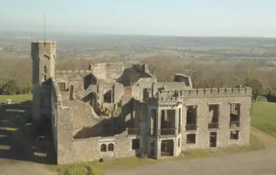
The castle of Mont-Cerisy is located in the commune of Cerisy-Belle-Étoile in the Orne (Normandy). The Mont de Cerisy, locally known as the "Mount of Rhodos", is largely covered with tree rhododendron plantations. From May to July, the flowering of these trees is a unique phenomenon that attracts visitors from all over the region. The rhododendron has become the symbol of the locality. At the top of the rhodos mountain stand the ruins of the castle. It was a manor house topped by a crenellated tower, built in the Tudor Revival style in the 1870s on the initiative of a wealthy London lawyer and later taken over by a local industrialist. Used by the Germans during the Second World War as a Luftwaffe communications centre, the building was bombed by the British air force in 1944 and was only partially restored.
Map and restricted areas
Open in the main mapNearby aerodromes
Open aerodromes within 25 km of the spot, heliports included, with their distance and direction from the spot. Near an aerodrome, drone flying is prohibited or height-limited: check the UAS zones map.
| Aerodrome | Type | Distance | Elevation | Difference |
|---|---|---|---|---|
| Aérodrome de Flers Saint-Paul | Aerodrome | 5.5 km SE | 200 m | spot 46 m higher |
Aviation weather (METAR and TAF)
LFRK – Caen-Carpiquet Airport LIFR
METAR
METAR LFRK 210630Z AUTO 14003KT 110V180 1200 0900NW R30/1100U BR BCFG VV/// 08/08 Q1017 TEMPO 0300 FG VV///
- Wind
- 140°, 6 km/h
- Visibility
- 1.2 km
- Weather
- Patches of fog ; mist
- Clouds
- –
- Temperature
- 8 °C, dew point 8 °C
- QNH
- 1017 hPa
- Flight category
- LIFR: ceiling < 500 ft or visibility < 1 mi
TAF
TAF LFRK 210500Z 2106/2115 VRB05KT 3000 BR BKN003 TEMPO 2106/2110 0300 FG VV/// BECMG 2110/2112 9999 NSW BKN006 BECMG 2112/2114 14010KT BKN012
| Period (local time) | Change | Wind | Visibility | Weather | Clouds |
|---|---|---|---|---|---|
| 21/11 07:00 → 21/11 11:00 | Initial conditions | Variable, 9 km/h | 3.0 km | Mist | Broken (5-7/8) at 300 ft (90 m) |
| 21/11 07:00 → 21/11 11:00 | Temporarily | 300 m | Fog | ||
| 21/11 11:00 → 21/11 13:00 | Becoming | Variable, 9 km/h | 10 km or more | No significant weather | Broken (5-7/8) at 600 ft (180 m) |
| 21/11 13:00 → 21/11 16:00 | Becoming | 140°, 19 km/h | 10 km or more | No significant weather | Broken (5-7/8) at 1,200 ft (370 m) |
Weather and Kp index
Sunrise and sunset
| Day | Dawn | Sunrise | Golden hour | Sunset | Dusk | Day length |
|---|---|---|---|---|---|---|
| Sat 21 Nov | 07:45 | 08:20 | 08:20–09:11 · 16:26–17:16 | 17:16 | 17:51 | 8 h 55 |
| Sun 22 Nov | 07:47 | 08:22 | 08:22–09:13 · 16:24–17:15 | 17:15 | 17:51 | 8 h 53 |
| Mon 23 Nov | 07:48 | 08:23 | 08:23–09:15 · 16:23–17:14 | 17:14 | 17:50 | 8 h 51 |
| Tue 24 Nov | 07:49 | 08:25 | 08:25–09:16 · 16:22–17:14 | 17:14 | 17:49 | 8 h 48 |
| Wed 25 Nov | 07:51 | 08:26 | 08:26–09:18 · 16:21–17:13 | 17:13 | 17:48 | 8 h 46 |
| Thu 26 Nov | 07:52 | 08:28 | 08:28–09:20 · 16:20–17:12 | 17:12 | 17:48 | 8 h 44 |
| Fri 27 Nov | 07:53 | 08:29 | 08:29–09:21 · 16:19–17:11 | 17:11 | 17:47 | 8 h 42 |


Reviews
Log in to review this spot. Log in · Create a free account
gabletab
Petit mont avec une vue sympa, de la place pour voler et un belle ruine de château.