

CHÂTEAU DE MONTAIGUILLON
No reviews yet
Have you flown here? Share your experience with other pilots.
+ Write the first reviewDescription
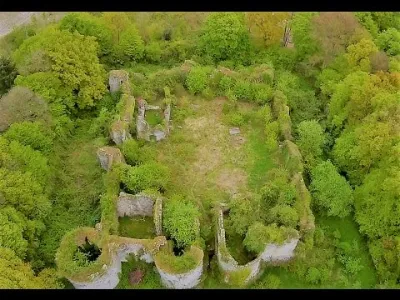
The construction of the fortress of Montaiguillon was probably undertaken under Blanche de Navarre ( 1177 - 1229 ), regent of the County of Champagne, during the minority of her son Thibault IV.
The castle suffered its first siege in 1420 by the troops of Claude de Beauvoir de Chastelux under the orders of the Duke of Burgundy.
It was besieged again in June 1423, for eight months, by the English commanded by Thomas de Montaigu, Count of Salisbury.
The Anglo-Burgundian alliance prospered in the 1420s until the providential appearance of Joan of Arc on the political scene.
An appearance that came at a time when the French warlords had a beginning of national awareness, wanted once again to stand behind the banner of the King of France, the King of Bourges in this case, the future Charles VII, and, in the process, to ensure the salvation of their souls by his sacrament in Rheims.
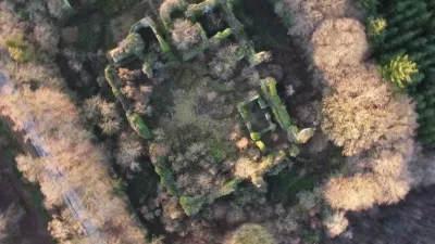
By order of Cardinal de Richelieu, the fortress of Montaiguillon was partially dismantled in 1613.
The ruins of the castle were classified as a historical monument in 1875 and, in 1971, the Société Civile Immobilière du Château de Montaiguillon planned its restoration (removal of stones, enhancement of the site and opening to visitors).
In April 2002, a tragic event led to its closure to the public. Source: http://www.la-defaite-oubliee.com/article-chateau-de-montaiguillon-commune-de-louan-villegruis-fontaine-seine-marne-62624570.html
Musical Source: https://www.youtube.com/watch?v=XtWYCjZ-dV0
Map and restricted areas
Open in the main mapNearby aerodromes
Open aerodromes within 25 km of the spot, heliports included, with their distance and direction from the spot. Near an aerodrome, drone flying is prohibited or height-limited: check the UAS zones map.
| Aerodrome | Type | Distance | Elevation | Difference |
|---|---|---|---|---|
| La Ferté Gaucher Airfield | Aerodrome | 21 km NW | 164 m | spot 31 m higher |
| Sézanne St Rémy Airfield | Aerodrome | 21 km NE | 108 m | spot 87 m higher |
Aviation weather (METAR and TAF)
No METAR station within 50 km.
Weather and Kp index
Sunrise and sunset
| Day | Dawn | Sunrise | Golden hour | Sunset | Dusk | Day length |
|---|---|---|---|---|---|---|
| Sat 21 Nov | 07:28 | 08:03 | 08:03–08:54 · 16:10–17:00 | 17:00 | 17:35 | 8 h 57 |
| Sun 22 Nov | 07:30 | 08:05 | 08:05–08:56 · 16:09–16:59 | 16:59 | 17:34 | 8 h 54 |
| Mon 23 Nov | 07:31 | 08:06 | 08:06–08:57 · 16:07–16:59 | 16:59 | 17:34 | 8 h 52 |
| Tue 24 Nov | 07:32 | 08:08 | 08:08–08:59 · 16:06–16:58 | 16:58 | 17:33 | 8 h 49 |
| Wed 25 Nov | 07:34 | 08:09 | 08:09–09:01 · 16:05–16:57 | 16:57 | 17:32 | 8 h 47 |
| Thu 26 Nov | 07:35 | 08:10 | 08:10–09:02 · 16:04–16:56 | 16:56 | 17:32 | 8 h 45 |
| Fri 27 Nov | 07:36 | 08:12 | 08:12–09:04 · 16:03–16:55 | 16:55 | 17:31 | 8 h 43 |

Reviews
Log in to review this spot. Log in · Create a free account
No reviews yet. Share yours!