

Burton Pynsent - Curry Rivel, Somerset.
No reviews yet
Have you flown here? Share your experience with other pilots.
+ Write the first reviewDescription
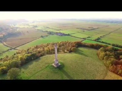
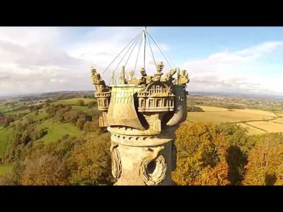
The 140 feet (43 m) Burton Pynsent Monument on Troy Hill at Burton Pynsent, within the parish of Curry Rivel, Somerset, England, was built in 1767 and has been designated as a Grade I listed building.[1]
Alternative names for the tower, which stands on Troy Hill, a spur of high ground about 700 m north-east of Burton Pynsent House, include the Curry Rivel Column, Pynsent Column, Pynsent Steeple or Cider Monument.[2]
The monument, which is clad in Portland Stone, was designed by Capability Brown and built by Philip Pear,[3] at a cost of £2,000,[4] for William Pitt as a monument to Sir William Pynsent,[5] of the Pynsent Baronets.
Pynsent was grateful to Pitt for opposing a ten shilling tax on a hogshead of cider (1763 Cider Bill), which would have affected his business, so on his death he left his entire estate to Pitt.[6][7] Pitt then used some of the income from the estate (£3000 per annum) to erect the monument to his benefactor.
In June 1948 it was reported that a heifer climbed the 172 steps to the top of the monument, but was later returned safely to her hillside pasture.[8]
The tower was restored in the 1990s by the John Paul Getty Trust and English Heritage.[2]
Map and restricted areas
Open in the main mapAviation weather (METAR and TAF)
EGDY – RNAS Yeovilton VFR
METAR
METAR EGDY 211220Z AUTO 10009KT 9999 OVC056/// 11/07 Q1015
- Wind
- 100°, 17 km/h
- Visibility
- 10 km or more
- Clouds
- Overcast (8/8) at 5,600 ft (1710 m)
- Temperature
- 11 °C, dew point 7 °C
- QNH
- 1015 hPa
- Flight category
- VFR: ceiling > 3,000 ft and visibility > 5 mi
TAF
Weather and Kp index
Sunrise and sunset
| Day | Dawn | Sunrise | Golden hour | Sunset | Dusk | Day length |
|---|---|---|---|---|---|---|
| Sat 21 Nov | 07:01 | 07:38 | 07:38–08:32 · 15:22–16:17 | 16:17 | 16:54 | 8 h 39 |
| Sun 22 Nov | 07:02 | 07:39 | 07:39–08:34 · 15:21–16:16 | 16:16 | 16:53 | 8 h 36 |
| Mon 23 Nov | 07:04 | 07:41 | 07:41–08:36 · 15:20–16:15 | 16:15 | 16:52 | 8 h 34 |
| Tue 24 Nov | 07:05 | 07:42 | 07:42–08:38 · 15:18–16:14 | 16:14 | 16:51 | 8 h 31 |
| Wed 25 Nov | 07:06 | 07:44 | 07:44–08:40 · 15:17–16:13 | 16:13 | 16:51 | 8 h 29 |
| Thu 26 Nov | 07:08 | 07:46 | 07:46–08:42 · 15:16–16:12 | 16:12 | 16:50 | 8 h 26 |
| Fri 27 Nov | 07:09 | 07:47 | 07:47–08:43 · 15:15–16:11 | 16:11 | 16:49 | 8 h 24 |
Reviews
Log in to review this spot. Log in · Create a free account
No reviews yet. Share yours!