

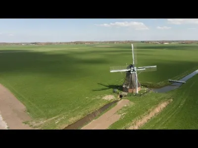
Aerial images of the Western Mill - Rare peace in Nieuw Scheemda
No reviews yet
Have you flown here? Share your experience with other pilots.
+ Write the first reviewDescription
Images edited and uploaded by me The mill is situated on the Buiten Nieuwediep between Noordbroek and Nieuw-Scheemda. Halfway the Pastorieweg there is a car park from where you can reach the mill on foot or by bike. The mill was built in 1862 as a replacement for the mill burned down that year in 1798 by mill maker Kamphuis from Niewolda. Originally, the mill with its two augers drained the water board Westerse Molenpolder (662 ha. large) and from 1878 it functioned as an auxiliary pumping station for a steam pumping station put into service. When a cast iron top axle was fitted in 1893, the blade cross was provided with self-weighing. Since 1964 this steam pumping station was replaced by a pumping station with a 60 hp diesel engine.
In 1967, the water board merged with other neighbouring polders into the Oldambt water board. As a result, the old steam pumping station and the miller's house near the mill were demolished. Because of its function as a reserve pumping station, the mill was preserved and thoroughly restored in 1970. In 1983 a new fled with self-sacrifice was applied, but in 1994 the mill got old-Dutch fled.
The mill is one of the 5 mills in Groningen with two mortars, an old rod has been reused as a bridge. Is one of the few Groninger mills that has the long sprout for the top wheel in the hood.
The two augers both have a head of 1.25 meters with auger bowls of concrete. Length large mortar: 9.25 m diameter 1.25 m. A special feature of this is the wooden mortar beam and iron paddle/lubbs. Length small mortar: 9.65 m diameter 1 meter and completely made of wood.
Over the years the state of maintenance had become poor and in 2010 the restoration was started within the framework of RRWR. This was carried out by mill maker A. Doornbosch from Adorp. Thus the large mortar was repaired, twelve new crawling-poles placed, three fields. Images received edited by me Music Youtube library 'Water Lily The 126ers'
Map and restricted areas
Open in the main mapAviation weather (METAR and TAF)
EHGG – Eelde Airport VFR
METAR
METAR EHGG 210725Z AUTO 22005KT 9999 NCD 01/01 Q1015 TEMPO 6000 SHRA FEW020CB
- Wind
- 220°, 9 km/h
- Visibility
- 10 km or more
- Clouds
- –
- Temperature
- 1 °C, dew point 1 °C
- QNH
- 1015 hPa
- Flight category
- VFR: ceiling > 3,000 ft and visibility > 5 mi
TAF
TAF EHGG 210515Z 2106/2212 26007KT 9999 SCT035 TEMPO 2106/2115 6000 SHRA FEW025CB PROB30 TEMPO 2115/2203 7000 -SHRA FEW030TCU PROB40 2121/2209 1200 BR BCFG
| Period (local time) | Change | Wind | Visibility | Weather | Clouds |
|---|---|---|---|---|---|
| 21/11 07:00 → 22/11 13:00 | Initial conditions | 260°, 13 km/h | 10 km or more | Scattered (3-4/8) at 3,500 ft (1070 m) | |
| 21/11 07:00 → 21/11 16:00 | Temporarily | 6 km | Showers of rain | Few (1-2/8) at 2,500 ft (760 m) (cumulonimbus) | |
| 21/11 16:00 → 22/11 04:00 | Temporarily, probability 30% | 7 km | Showers of rain light | Few (1-2/8) at 3,000 ft (910 m) (towering cumulus) | |
| 21/11 22:00 → 22/11 10:00 | probability 40% | 1.2 km | Mist ; patches of fog |
Weather and Kp index
Sunrise and sunset
| Day | Dawn | Sunrise | Golden hour | Sunset | Dusk | Day length |
|---|---|---|---|---|---|---|
| Sat 21 Nov | 07:28 | 08:08 | 08:08–09:07 · 15:29–16:29 | 16:29 | 17:08 | 8 h 21 |
| Sun 22 Nov | 07:30 | 08:09 | 08:09–09:09 · 15:28–16:28 | 16:28 | 17:07 | 8 h 18 |
| Mon 23 Nov | 07:31 | 08:11 | 08:11–09:11 · 15:26–16:26 | 16:26 | 17:06 | 8 h 15 |
| Tue 24 Nov | 07:33 | 08:13 | 08:13–09:13 · 15:25–16:25 | 16:25 | 17:05 | 8 h 12 |
| Wed 25 Nov | 07:34 | 08:14 | 08:14–09:15 · 15:23–16:24 | 16:24 | 17:04 | 8 h 09 |
| Thu 26 Nov | 07:36 | 08:16 | 08:16–09:17 · 15:22–16:23 | 16:23 | 17:04 | 8 h 07 |
| Fri 27 Nov | 07:37 | 08:18 | 08:18–09:19 · 15:21–16:22 | 16:22 | 17:03 | 8 h 04 |
Reviews
Log in to review this spot. Log in · Create a free account
No reviews yet. Share yours!