

Louis Vicat Bridge, Dordogne
1 pilot review
“Vous pouvez trouver une vidéo FPV faite sur ce spot sur mon Instagram: baptiste_nonat” — BAPTISTENONAT, 4 years ago
Read the reviews + Write my reviewDescription
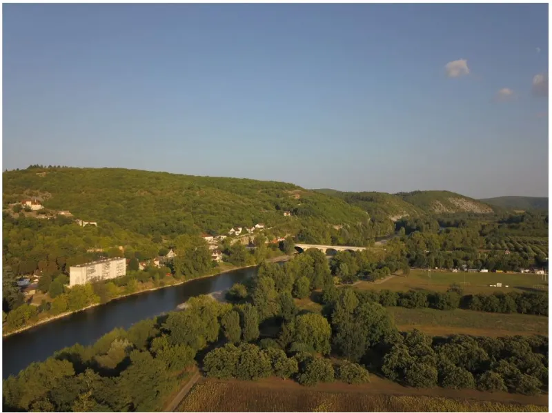
Spotlight to fly over the Dordogne and the bridge linking Souillac to Lanzac (Louis Vicat Bridge) Take-off from the field behind the bank (Lanzac side), direct access by car.
The maximum flying height is 50 meters Be careful not to fly over the campsite and the nearby swimming beach, it is however very easy to get around this area by taking off in the area I have indicated and flying directly in the axis of the Dordogne.
Map and restricted areas
Open in the main mapNearby aerodromes
Open aerodromes within 25 km of the spot, heliports included, with their distance and direction from the spot. Near an aerodrome, drone flying is prohibited or height-limited: check the UAS zones map.
| Aerodrome | Type | Distance | Elevation | Difference |
|---|---|---|---|---|
| Aérodrome de Peyrillac | Aerodrome | 5.1 km W | 274 m | spot 187 m lower |
| Aérodrome de Loupiac | Aerodrome | 6.1 km S | 273 m | spot 185 m lower |
| Aérodrome de Lacave le Frau | Aerodrome | 9.8 km SE | 299 m | spot 211 m lower |
| Brive-Souillac | Airport | 17 km N | 310 m | spot 222 m lower |
| La Canéda Centre Hospitalier Heliport | Heliport | 20 km W | 200 m | spot 112 m lower |
Aviation weather (METAR and TAF)
LFSL – Brive-Souillac IFR
METAR
METAR LFSL 211030Z AUTO 14006KT 100V180 9999 BKN009 13/11 Q1019 BECMG NSC
- Wind
- 140°, 11 km/h
- Visibility
- 10 km or more
- Clouds
- Broken (5-7/8) at 900 ft (270 m)
- Temperature
- 13 °C, dew point 11 °C
- QNH
- 1019 hPa
- Flight category
- IFR: ceiling 500–1,000 ft or visibility 1–3 mi
TAF
TAF LFSL 210800Z 2109/2118 15005KT 9999 OVC004 BECMG 2109/2111 CAVOK
| Period (local time) | Change | Wind | Visibility | Weather | Clouds |
|---|---|---|---|---|---|
| 21/11 10:00 → 21/11 19:00 | Initial conditions | 150°, 9 km/h | 10 km or more | Overcast (8/8) at 400 ft (120 m) | |
| 21/11 10:00 → 21/11 19:00 | Becoming | 150°, 9 km/h | 10 km or more | No significant weather | No significant cloud |
Weather and Kp index
Sunrise and sunset
| Day | Dawn | Sunrise | Golden hour | Sunset | Dusk | Day length |
|---|---|---|---|---|---|---|
| Sat 21 Nov | 07:27 | 07:59 | 07:59–08:45 · 16:35–17:21 | 17:21 | 17:53 | 9 h 21 |
| Sun 22 Nov | 07:28 | 08:01 | 08:01–08:46 · 16:34–17:20 | 17:20 | 17:52 | 9 h 19 |
| Mon 23 Nov | 07:30 | 08:02 | 08:02–08:48 · 16:33–17:19 | 17:19 | 17:51 | 9 h 17 |
| Tue 24 Nov | 07:31 | 08:03 | 08:03–08:49 · 16:32–17:18 | 17:18 | 17:51 | 9 h 15 |
| Wed 25 Nov | 07:32 | 08:04 | 08:04–08:51 · 16:31–17:18 | 17:18 | 17:50 | 9 h 13 |
| Thu 26 Nov | 07:33 | 08:06 | 08:06–08:52 · 16:31–17:17 | 17:17 | 17:50 | 9 h 11 |
| Fri 27 Nov | 07:34 | 08:07 | 08:07–08:54 · 16:30–17:16 | 17:16 | 17:49 | 9 h 09 |

Reviews
Log in to review this spot. Log in · Create a free account
BAPTISTENONAT
Vous pouvez trouver une vidéo FPV faite sur ce spot sur mon Instagram: baptiste_nonat