

Heritage
In the commune of Brignais in the Rhone (69)

1 pilot review
“Merci pour ce partage, je me suis garé à 1km à cause des panneaux qui indiquent accès rése…” — Former member, 4 years ago
Read the reviews + Write my reviewDescription
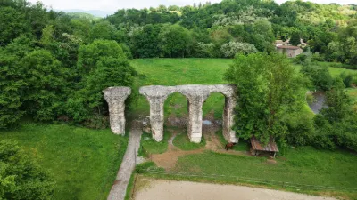
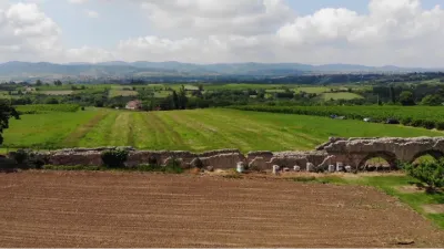
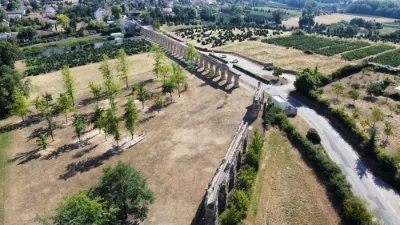
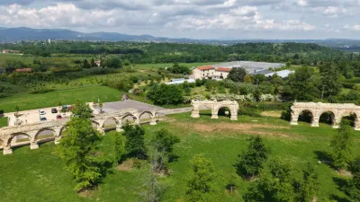
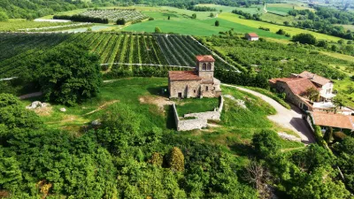
Very beautiful remains of the Garon siphon bridge, the Roman aqueduct of Gier
Video
Map and restricted areas
Open in the main mapNearby aerodromes
Open aerodromes within 25 km of the spot, heliports included, with their distance and direction from the spot. Near an aerodrome, drone flying is prohibited or height-limited: check the UAS zones map.
| Aerodrome | Type | Distance | Elevation | Difference |
|---|---|---|---|---|
| Lyon Brindas Airfield | Aerodrome | 4.2 km NW | 317 m | spot 101 m lower |
| Hôpital Edouard-Herriot Heliport | Heliport | 13 km NE | 199 m | spot 17 m higher |
| Aérodrome de Lyon - Corbas | Aerodrome | 14 km E | 198 m | spot 18 m higher |
| Lyon-Bron Airport | Airport | 16 km E | 201 m | spot 15 m higher |
Aviation weather (METAR and TAF)
LFLY – Lyon-Bron Airport VFR
METAR
METAR LFLY 210630Z AUTO VRB01KT 9999 BKN037/// OVC043/// OVC049/// ///TCU 09/08 Q1020 TEMPO 5000 -RA BECMG NSC
- Wind
- Variable, 2 km/h
- Visibility
- 10 km or more
- Clouds
- Broken (5-7/8) at 3,700 ft (1130 m) ; Overcast (8/8) at 4,300 ft (1310 m) ; Overcast (8/8) at 4,900 ft (1490 m)
- Temperature
- 9 °C, dew point 8 °C
- QNH
- 1020 hPa
- Flight category
- VFR: ceiling > 3,000 ft and visibility > 5 mi
TAF
TAF LFLY 210500Z 2106/2206 15006KT CAVOK PROB40 TEMPO 2106/2108 5000 -RA BKN040 TEMPO 2200/2205 4000 RA OVC035 PROB40 TEMPO 2203/2206 15015KT BKN014
| Period (local time) | Change | Wind | Visibility | Weather | Clouds |
|---|---|---|---|---|---|
| 21/11 07:00 → 22/11 07:00 | Initial conditions | 150°, 11 km/h | 10 km or more | No significant weather | No significant cloud |
| 21/11 07:00 → 21/11 09:00 | Temporarily, probability 40% | 5 km | Rain light | Broken (5-7/8) at 4,000 ft (1220 m) | |
| 22/11 01:00 → 22/11 06:00 | Temporarily | 4.0 km | Rain | Overcast (8/8) at 3,500 ft (1070 m) | |
| 22/11 04:00 → 22/11 07:00 | Temporarily, probability 40% | 150°, 28 km/h | Broken (5-7/8) at 1,400 ft (430 m) |
Weather and Kp index
Sunrise and sunset
| Day | Dawn | Sunrise | Golden hour | Sunset | Dusk | Day length |
|---|---|---|---|---|---|---|
| Sat 21 Nov | 07:16 | 07:49 | 07:49–08:35 · 16:18–17:05 | 17:05 | 17:38 | 9 h 16 |
| Sun 22 Nov | 07:17 | 07:50 | 07:50–08:37 · 16:17–17:04 | 17:04 | 17:37 | 9 h 14 |
| Mon 23 Nov | 07:19 | 07:51 | 07:51–08:38 · 16:17–17:03 | 17:03 | 17:36 | 9 h 12 |
| Tue 24 Nov | 07:20 | 07:53 | 07:53–08:40 · 16:16–17:03 | 17:03 | 17:36 | 9 h 10 |
| Wed 25 Nov | 07:21 | 07:54 | 07:54–08:41 · 16:15–17:02 | 17:02 | 17:35 | 9 h 08 |
| Thu 26 Nov | 07:22 | 07:55 | 07:55–08:43 · 16:14–17:01 | 17:01 | 17:34 | 9 h 06 |
| Fri 27 Nov | 07:23 | 07:56 | 07:56–08:44 · 16:13–17:01 | 17:01 | 17:34 | 9 h 04 |
Reviews
Log in to review this spot. Log in · Create a free account
Former member
Merci pour ce partage, je me suis garé à 1km à cause des panneaux qui indiquent accès réservé. On est au milieu d'un centre équestre et d'une ferme, volons dans le respect. https://youtu.be/Hq2ix8cjIIQ