

Tronçais Forest
No reviews yet
Have you flown here? Share your experience with other pilots.
+ Write the first reviewDescription
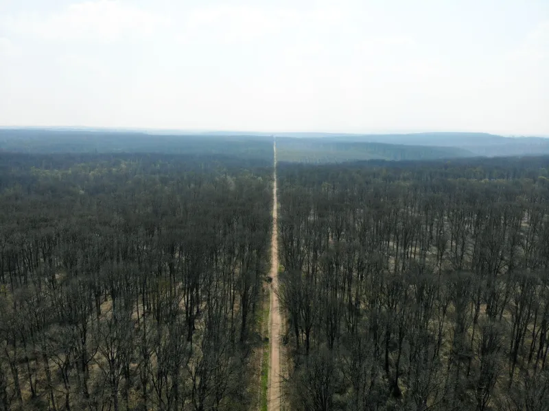
Stretching over nearly 11,000 hectares, the Tronçais forest is one of the most beautiful forest massifs in France. The forest has been carved over and over again, and has finally regained its rights and now boasts specimens that are several hundred years old.
This important oak grove also has beeches and hornbeams to force the oaks to seek the light ever higher. The 40-metre barrels thus obtained (after some 250 years!) place the vault of vegetation at the height of the cathedrals. The forest retains a rare atmosphere, an impressive majesty. Crossed by Caesar, rehabilitated under Colbert, once full of Gallic Maquis camps and Gallo-Roman sites, the forest still preserves traces of the passage of man since prehistoric times. It is by taking their time, snooping here and there under the woods, that walkers really discover the forest and appreciate its vestiges, the freshness of a fountain...
Water gushes out at many points, making streams run beneath the leaves and between the roots. About 40 fountains have been identified in the woods. For the most part secret and left to their fate, they were once carefully maintained, so vital was their purity.
The forest has always been inhabited. In the commune of Le Brethon, the priory of La Bouteille, of which only the Saint Mayeul chapel remains, reports that the Benedictine monks came to isolate themselves in the forest 1000 years ago.
Still in the 19th century, many huts and cabins occupied the undergrowth. Lumberjacks, splitters and charcoal burners stayed at their place of work and built their shelters according to a model typical of their trade. Still in business, the Merandiers shape Tronçais wood to make barrels for the greatest wines of Bordeaux.
The Tronçais forest was awarded the label "Forest of exception" in 2018. The aim of this programme is to demonstrate the excellence of France's forestry heritage and to promote its development by helping the region to implement innovative measures.
Map and restricted areas
Open in the main mapNearby aerodromes
Open aerodromes within 25 km of the spot, heliports included, with their distance and direction from the spot. Near an aerodrome, drone flying is prohibited or height-limited: check the UAS zones map.
| Aerodrome | Type | Distance | Elevation | Difference |
|---|---|---|---|---|
| Aérodrome de Lurcy-Levis | Aerodrome | 15 km E | 227 m | same altitude as the spot |
Aviation weather (METAR and TAF)
LFOA – Avord (BA 702) Air Base MVFR
METAR
METAR LFOA 211130Z AUTO 18004KT 150V220 9999 BKN019 OVC025 12/09 Q1018
- Wind
- 180°, 7 km/h
- Visibility
- 10 km or more
- Clouds
- Broken (5-7/8) at 1,900 ft (580 m) ; Overcast (8/8) at 2,500 ft (760 m)
- Temperature
- 12 °C, dew point 9 °C
- QNH
- 1018 hPa
- Flight category
- MVFR: ceiling 1,000–3,000 ft or visibility 3–5 mi
TAF
Weather and Kp index
Sunrise and sunset
| Day | Dawn | Sunrise | Golden hour | Sunset | Dusk | Day length |
|---|---|---|---|---|---|---|
| Sat 21 Nov | 07:26 | 08:00 | 08:00–08:48 · 16:22–17:10 | 17:10 | 17:43 | 9 h 10 |
| Sun 22 Nov | 07:28 | 08:01 | 08:01–08:49 · 16:21–17:09 | 17:09 | 17:42 | 9 h 07 |
| Mon 23 Nov | 07:29 | 08:02 | 08:02–08:51 · 16:20–17:08 | 17:08 | 17:42 | 9 h 05 |
| Tue 24 Nov | 07:30 | 08:04 | 08:04–08:52 · 16:19–17:07 | 17:07 | 17:41 | 9 h 03 |
| Wed 25 Nov | 07:31 | 08:05 | 08:05–08:54 · 16:18–17:07 | 17:07 | 17:40 | 9 h 01 |
| Thu 26 Nov | 07:33 | 08:06 | 08:06–08:55 · 16:17–17:06 | 17:06 | 17:40 | 8 h 59 |
| Fri 27 Nov | 07:34 | 08:08 | 08:08–08:57 · 16:16–17:05 | 17:05 | 17:39 | 8 h 57 |

Reviews
Log in to review this spot. Log in · Create a free account
No reviews yet. Share yours!