

Meyrargues 13
3 pilot reviews
“Bonjour, il faut suivre le Pas de l'étroit pour accéder à la vigie, route qui remonte le c…” — Gaëtan13650, 5 years ago
Read the reviews + Write my reviewDescription
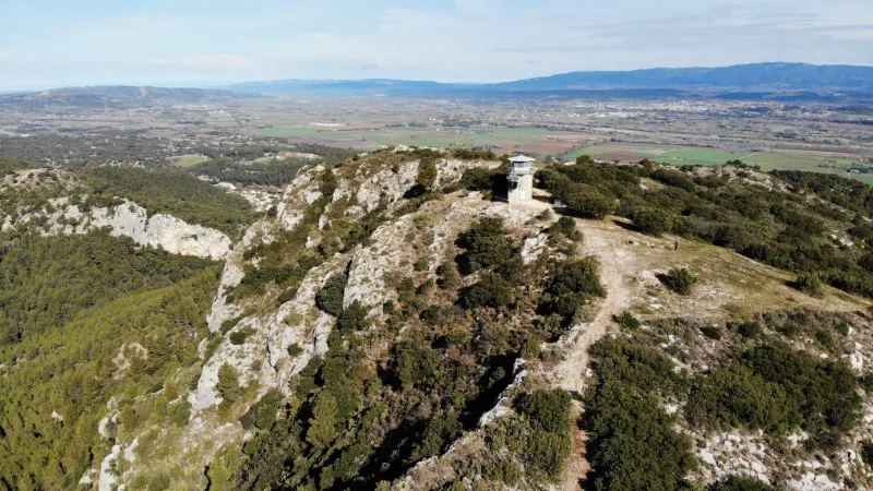
Access to the fire lookout via the ridges. Nice views over the Durance valley and the Ste Victoire. Departure from the cemetery of Meyrargues.
Map and restricted areas
Open in the main mapNearby aerodromes
Open aerodromes within 25 km of the spot, heliports included, with their distance and direction from the spot. Near an aerodrome, drone flying is prohibited or height-limited: check the UAS zones map.
| Aerodrome | Type | Distance | Elevation | Difference |
|---|---|---|---|---|
| Pays d'Aix Medical Center Heliport | Heliport | 13 km SW | 222 m | spot 173 m higher |
| Aix - Les Milles Airport | Aerodrome | 20 km SW | 112 m | spot 283 m higher |
| Saint Suffren private UL strip | Aerodrome | 21 km W | 270 m | spot 124 m higher |
| Aérodrome de Vinon | Aerodrome | 22 km NE | 275 m | spot 119 m higher |
Aviation weather (METAR and TAF)
LFML – Marseille Provence Airport VFR
METAR
METAR LFML 211030Z AUTO VRB02KT CAVOK 14/08 Q1020 NOSIG
- Wind
- Variable, 4 km/h
- Visibility
- 10 km or more
- Clouds
- –
- Temperature
- 14 °C, dew point 8 °C
- QNH
- 1020 hPa
- Flight category
- VFR: ceiling > 3,000 ft and visibility > 5 mi
TAF
TAF LFML 210800Z 2109/2215 VRB03KT CAVOK TX17/2117Z TN13/2205Z BECMG 2116/2118 12010KT BECMG 2119/2121 -SHRA TEMPO 2120/2209 4000 SHRA BKN012 BKN025TCU BECMG 2208/2210 26020G35KT NSW
| Period (local time) | Change | Wind | Visibility | Weather | Clouds |
|---|---|---|---|---|---|
| 21/11 10:00 → 21/11 17:00 | Initial conditions | Variable, 6 km/h | 10 km or more | No significant cloud | |
| 21/11 17:00 → 21/11 20:00 | Becoming | 120°, 19 km/h | 10 km or more | No significant cloud | |
| 21/11 20:00 → 22/11 09:00 | Becoming | 120°, 19 km/h | 10 km or more | Showers of rain light | No significant cloud |
| 21/11 21:00 → 22/11 10:00 | Temporarily | 4.0 km | Showers of rain | Broken (5-7/8) at 1,200 ft (370 m) ; Broken (5-7/8) at 2,500 ft (760 m) (towering cumulus) | |
| 22/11 09:00 → 22/11 16:00 | Becoming | 260°, 37 km/h, gusts 65 km/h | 10 km or more | No significant weather | No significant cloud |
Weather and Kp index
Sunrise and sunset
| Day | Dawn | Sunrise | Golden hour | Sunset | Dusk | Day length |
|---|---|---|---|---|---|---|
| Sat 21 Nov | 07:08 | 07:39 | 07:39–08:24 · 16:24–17:08 | 17:08 | 17:39 | 9 h 28 |
| Sun 22 Nov | 07:09 | 07:41 | 07:41–08:25 · 16:23–17:07 | 17:07 | 17:39 | 9 h 26 |
| Mon 23 Nov | 07:10 | 07:42 | 07:42–08:26 · 16:22–17:06 | 17:06 | 17:38 | 9 h 24 |
| Tue 24 Nov | 07:11 | 07:43 | 07:43–08:28 · 16:21–17:06 | 17:06 | 17:37 | 9 h 22 |
| Wed 25 Nov | 07:13 | 07:44 | 07:44–08:29 · 16:20–17:05 | 17:05 | 17:37 | 9 h 21 |
| Thu 26 Nov | 07:14 | 07:45 | 07:45–08:30 · 16:20–17:05 | 17:05 | 17:36 | 9 h 19 |
| Fri 27 Nov | 07:15 | 07:47 | 07:47–08:32 · 16:19–17:04 | 17:04 | 17:36 | 9 h 17 |



Reviews
Log in to review this spot. Log in · Create a free account
Gaëtan13650
Bonjour, il faut suivre le Pas de l'étroit pour accéder à la vigie, route qui remonte le cimetière prendre le chemin à gauche (à droite c'est la montée du château) suivre jusqu'au bout (route étroite et sinueuse) pour arriver sur un petit parking en terre, ensuite faire à pied jusqu'à la vigie :)
AUDO13
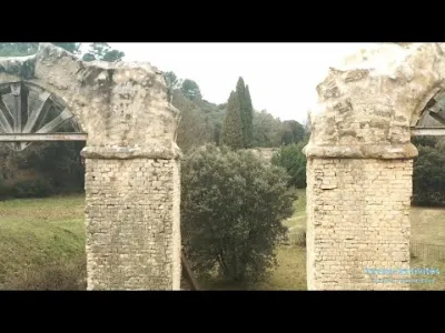
Bonjour,les coordonnées gps ne doivent pas être correctes. Pour y accéder il faut prendre la randonnée qui part des ruines de l’aqueduc romain à Meyrargues et suivre la ligne de crête jusqu’à la vigie.
ch4rko21
Bonjour, nous nous sommes rendu sur les lieux, et rien du tout aux coordonnées GPS renseignées...