

Rogliano, Haute-Corse

No reviews yet
Have you flown here? Share your experience with other pilots.
+ Write the first reviewDescription
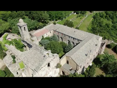
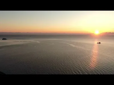
The convent was built in 1520 and restored in 1711; its church (burial place) and picturesque bell tower are in a state of disrepair. The convent, which has been disused since 1789, is now privately owned and offers an exceptional panorama of the sea and the Tuscan Archipelago. In 1785, the Cap Corse had 13 convents (Servites, Récollets, Capuchins, Observantins and Franciscans). Twenty-eighth convent of the Franciscan Province of Corsica, founded in 1520 under the pontificate of Leo X, it houses four monks in 1570. The original church, which is smaller than the present building, is normally oriented to the east (high altar). In 1620, the primitive convent (now the west wing) was completed and now houses eight nuns. On 14 September 1654 the Convent of Rogliano became a House of Professorat (twelve religious). June 30, 1671, consecration of the monastery church, which was enlarged and the interior layout changed (high altar in the west), dedicated to Saint-Blaise and Saint-Vincent. 1720, eighteen religious, north wing almost finished. 1750, the convent reached its final version, 30 religious. 1751, the church of San Francesco is equipped with the first organ installed in Rogliano (probably an instrument of Giuseppe Lazari from Milan). 1791, abolition of the monastic orders, the convent is sold as national property in 1794. The works of art that adorned his church are fortunately transported to the parish. The monastery church served as a burial place for more than two centuries for the Franciscan community (common grave) as well as for many families from Rome who had acquired mortuary concessions there. The convent welcomed within its walls two famous guests: General Marquis de Cursay during his visit to the construction site of the first port of Macinaggio in November 1749 and Pascal Paoli during the siege of this same port at the end of September 1761. In 1780 the Franciscan Father Benedetto Marracci of Rogliano, an organ builder of Lucchese origin, built the organ of the parish church of La Porta.
Map and restricted areas
Open in the main mapNearby aerodromes
Open aerodromes within 25 km of the spot, heliports included, with their distance and direction from the spot. Near an aerodrome, drone flying is prohibited or height-limited: check the UAS zones map.
No known open aerodrome within 25 km.
Aviation weather (METAR and TAF)
LFKB – Bastia-Poretta Airport VFR
METAR
METAR LFKB 210730Z AUTO 23005KT CAVOK ///// Q1017 NOSIG
- Wind
- 230°, 9 km/h
- Visibility
- 10 km or more
- Clouds
- –
- Temperature
- –
- QNH
- 1017 hPa
- Flight category
- VFR: ceiling > 3,000 ft and visibility > 5 mi
TAF
TAF LFKB 210200Z 2103/2203 27020G35KT CAVOK TX21/2111Z TN16/2105Z TEMPO 2103/2104 27030G45KT BECMG 2103/2104 VRB05KT
| Period (local time) | Change | Wind | Visibility | Weather | Clouds |
|---|---|---|---|---|---|
| 21/11 04:00 → 22/11 04:00 | Initial conditions | 270°, 37 km/h, gusts 65 km/h | 10 km or more | No significant cloud | |
| 21/11 04:00 → 21/11 05:00 | Temporarily | 270°, 56 km/h, gusts 83 km/h | |||
| 21/11 04:00 → 22/11 04:00 | Becoming | Variable, 9 km/h | 10 km or more | No significant cloud |
Weather and Kp index
Sunrise and sunset
| Day | Dawn | Sunrise | Golden hour | Sunset | Dusk | Day length |
|---|---|---|---|---|---|---|
| Sat 21 Nov | 06:51 | 07:22 | 07:22–08:06 · 16:11–16:54 | 16:54 | 17:25 | 9 h 32 |
| Sun 22 Nov | 06:52 | 07:23 | 07:23–08:07 · 16:10–16:54 | 16:54 | 17:25 | 9 h 30 |
| Mon 23 Nov | 06:53 | 07:24 | 07:24–08:08 · 16:09–16:53 | 16:53 | 17:24 | 9 h 28 |
| Tue 24 Nov | 06:55 | 07:26 | 07:26–08:10 · 16:08–16:52 | 16:52 | 17:23 | 9 h 26 |
| Wed 25 Nov | 06:56 | 07:27 | 07:27–08:11 · 16:08–16:52 | 16:52 | 17:23 | 9 h 24 |
| Thu 26 Nov | 06:57 | 07:28 | 07:28–08:12 · 16:07–16:51 | 16:51 | 17:22 | 9 h 23 |
| Fri 27 Nov | 06:58 | 07:29 | 07:29–08:14 · 16:06–16:51 | 16:51 | 17:22 | 9 h 21 |
Reviews
Log in to review this spot. Log in · Create a free account
No reviews yet. Share yours!