

Cheptainville Forest
1 pilot review
“Bon site d'entrainement au drone. Hauteur limite en 2020 : 50 mètres. Le matin, c'est calm…” — Erda1410, 6 years ago
Read the reviews + Write my reviewDescription
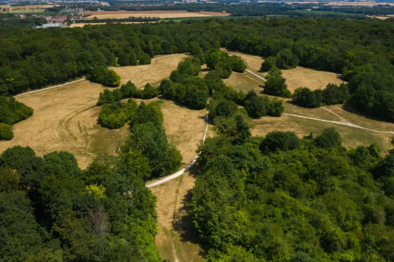
Parking nearby, large clearings for safe take-off and landing... Ideal ground for fine-tuning its settings or testing a new UAV (Caution: flight ceiling limited to 50 m). Sablière de Lardy a few turns of the propeller! Renault test track also nearby but don't get lost on this private and ultra-protected site ;) Have a good flight
Map and restricted areas
Open in the main mapNearby aerodromes
Open aerodromes within 25 km of the spot, heliports included, with their distance and direction from the spot. Near an aerodrome, drone flying is prohibited or height-limited: check the UAS zones map.
| Aerodrome | Type | Distance | Elevation | Difference |
|---|---|---|---|---|
| Cerny-La Ferté Alais Airfield | Aerodrome | 6.3 km SE | 138 m | same altitude as the spot |
| Centre Hospitalier Sud Francilien Heliport | Heliport | 17 km NE | 78 m | spot 58 m higher |
| Centre Hospitalier Heliport | Heliport | 17 km NE | 78 m | spot 59 m higher |
| Base ULM de Genevrelle à Maisse | Aerodrome | 18 km S | 128 m | spot 8 m higher |
| Paris-Orly Airport | Major airport | 22 km N | 89 m | spot 48 m higher |
Aviation weather (METAR and TAF)
LFPO – Paris-Orly Airport MVFR
METAR
METAR LFPO 210630Z 12003KT 8000 NSC 08/08 Q1018 TEMPO BKN008
- Wind
- 120°, 6 km/h
- Visibility
- 8 km
- Clouds
- –
- Temperature
- 8 °C, dew point 8 °C
- QNH
- 1018 hPa
- Flight category
- MVFR: ceiling 1,000–3,000 ft or visibility 3–5 mi
TAF
TAF LFPO 210500Z 2106/2212 17003KT 9999 SCT007 BECMG 2106/2107 BKN007 TEMPO 2107/2111 4000 BR BKN003 PROB40 TEMPO 2107/2110 0600 FG VV/// BECMG 2112/2115 10004KT BKN016 BECMG 2206/2208 4000 -RA TEMPO 2209/2212 BKN008
| Period (local time) | Change | Wind | Visibility | Weather | Clouds |
|---|---|---|---|---|---|
| 21/11 07:00 → 22/11 13:00 | Initial conditions | 170°, 6 km/h | 10 km or more | Scattered (3-4/8) at 700 ft (210 m) | |
| 21/11 07:00 → 21/11 13:00 | Becoming | 170°, 6 km/h | 10 km or more | Broken (5-7/8) at 700 ft (210 m) | |
| 21/11 08:00 → 21/11 12:00 | Temporarily | 4.0 km | Mist | Broken (5-7/8) at 300 ft (90 m) | |
| 21/11 08:00 → 21/11 11:00 | Temporarily, probability 40% | 600 m | Fog | ||
| 21/11 13:00 → 22/11 07:00 | Becoming | 100°, 7 km/h | 10 km or more | Broken (5-7/8) at 1,600 ft (490 m) | |
| 22/11 07:00 → 22/11 13:00 | Becoming | 100°, 7 km/h | 4.0 km | Rain light | Broken (5-7/8) at 1,600 ft (490 m) |
| 22/11 10:00 → 22/11 13:00 | Temporarily | Broken (5-7/8) at 800 ft (240 m) |
Weather and Kp index
Sunrise and sunset
| Day | Dawn | Sunrise | Golden hour | Sunset | Dusk | Day length |
|---|---|---|---|---|---|---|
| Sat 21 Nov | 07:33 | 08:08 | 08:08–08:58 · 16:15–17:06 | 17:06 | 17:40 | 8 h 57 |
| Sun 22 Nov | 07:34 | 08:09 | 08:09–09:00 · 16:14–17:05 | 17:05 | 17:40 | 8 h 55 |
| Mon 23 Nov | 07:36 | 08:11 | 08:11–09:02 · 16:13–17:04 | 17:04 | 17:39 | 8 h 52 |
| Tue 24 Nov | 07:37 | 08:12 | 08:12–09:03 · 16:12–17:03 | 17:03 | 17:38 | 8 h 50 |
| Wed 25 Nov | 07:38 | 08:14 | 08:14–09:05 · 16:11–17:02 | 17:02 | 17:37 | 8 h 48 |
| Thu 26 Nov | 07:40 | 08:15 | 08:15–09:07 · 16:10–17:01 | 17:01 | 17:37 | 8 h 46 |
| Fri 27 Nov | 07:41 | 08:16 | 08:16–09:08 · 16:09–17:01 | 17:01 | 17:36 | 8 h 44 |




Reviews
Log in to review this spot. Log in · Create a free account
Erda1410
Bon site d'entrainement au drone. Hauteur limite en 2020 : 50 mètres. Le matin, c'est calme. Le champ présente différents dénivelés. Dans la journée, présence de randonneurs et cyclistes. C'est un site à voir pour tester son engin. Bon vol.