Skip to content
Mountain

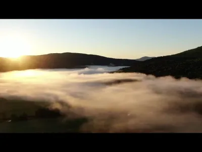
Missisquoi Valley
Canada

The video is only loaded from YouTube (youtube-nocookie.com) when you start it.

1 pilot review

“très bel endroit” — osbyte, 7 years ago

Read the reviews + Write my review

Description

Fields and river surrounded by mountains

Aviation weather (METAR and TAF)

KEFK – Northeast Kingdom International Airport · 28 km SE VFR

METAR

Observed 21/11 07:35 · 24 min ago

METAR KEFK 211235Z AUTO 21004KT 10SM CLR 00/00 A3037 RMK AO2 T00021004

Wind
210°, 7 km/h
Visibility
10 km or more
Clouds
–
Temperature
0 °C, dew point -0 °C
QNH
1028 hPa
Flight category
VFR: ceiling > 3,000 ft and visibility > 5 mi

TAF

Issued 21/11 06:38 · valid from 21/11 07:00 to 22/11 07:00

TAF KEFK 211138Z 2112/2212 22006KT P6SM FEW150 FM211400 18006KT P6SM SKC

Period (local time) Change Wind Visibility Weather Clouds
21/11 07:00 → 21/11 09:00 Initial conditions 220°, 11 km/h 10 km or more Few (1-2/8) at 15,000 ft (4570 m)
21/11 09:00 → 22/11 07:00 From 180°, 11 km/h 10 km or more Clear sky

Empty cell: no change forecast for that element.

METAR and TAF from NOAA (Aviation Weather Center), for guidance only: they do not replace flight planning with official sources (SIA, Météo-France). Nearest station that issues a METAR, not necessarily the nearest aerodrome.

Plan the light

Weather and Kp index

Loading forecast…

Sunrise and sunset

Local times at the spot (UTC−05:00). The golden hour, the warm, low light sought after for photos and videos, runs from sunrise until the sun reaches 6° above the horizon, and in the evening from 6° until sunset.

Day Dawn Sunrise Golden hour Sunset Dusk Day length
Sat 21 Nov06:24 06:56 06:56–07:42 · 15:30–16:16 16:16 16:489 h 19
Sun 22 Nov06:25 06:57 06:57–07:43 · 15:29–16:15 16:15 16:479 h 17
Mon 23 Nov06:26 06:59 06:59–07:45 · 15:28–16:14 16:14 16:479 h 15
Tue 24 Nov06:27 07:00 07:00–07:46 · 15:27–16:14 16:14 16:469 h 13
Wed 25 Nov06:29 07:01 07:01–07:48 · 15:26–16:13 16:13 16:469 h 11
Thu 26 Nov06:30 07:02 07:02–07:49 · 15:26–16:12 16:12 16:459 h 09
Fri 27 Nov06:31 07:04 07:04–07:50 · 15:25–16:12 16:12 16:449 h 08

Nearby on Wikipedia

  • Monts Sutton · 5.2 km away

    Les monts Sutton constituent la subdivision la plus septentrionale des montagnes Vertes. Elle est protégée en partie par la réserve naturelle des Montagnes-Vertes, la plus grande aire protégée privée du Canada à l'est des montagnes Rocheuses. (...)

  • Sommet Rond · 5.3 km away

    Le sommet Rond (appelé aussi Le Round Top) est un sommet des monts Sutton, dont il constitue le point culminant à d'altitude, dans la région de la Montérégie au Québec. Il est situé au nord de Glen Sutton et juste au sud-ouest du mont Gagnon, un autre sommet des monts Sutton (...)

  • Mont Gagnon · 5.5 km away

    Le mont Gagnon est un sommet des monts Sutton culminant à d'altitude, en Montérégie au Québec. Il est situé juste au nord-est du sommet Rond et au sud-ouest du mont Écho. Entre eux, se trouvent trois lacs : le lac Spruce, le lac Vogel, ainsi que le lac Mud Pound. (...)

  • Rivière Missisquoi Nord · 6.1 km away

    La rivière Missisquoi Nord est un tributaire de la rivière Missisquoi. La rivière Missisquoi Nord coule dans les municipalités de Eastman, Stukely-Sud, Saint-Étienne-de-Bolton, Bolton-Est, Mansonville et Potton, dans la municipalité régionale de comté (MRC) de Memphrémagog, dans la région (...)

  • Mont Écho · 7.0 km away

    Le mont Écho est un sommet des monts Sutton culminant à d'altitude, dans la municipalité de Sutton. Il offre une vue panoramique sur la chaîne des montagnes Vertes du Vermont. (...)

Articles found by GeoNames from the spot's position.

Reviews

Log in to review this spot. Log in · Create a free account

  1. osbyte

    très bel endroit

Connection to the site lost. Trying again…

The site is not responding. Trying again in seconds.

The site is no longer responding.

The site has been updated. Reloading the page…

This page has expired.

Resuming failed. Please reload the page.

The site is no longer responding.