

Rocher du Falkenstein
No reviews yet
Have you flown here? Share your experience with other pilots.
+ Write the first reviewDescription
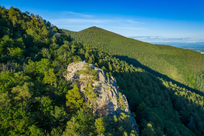
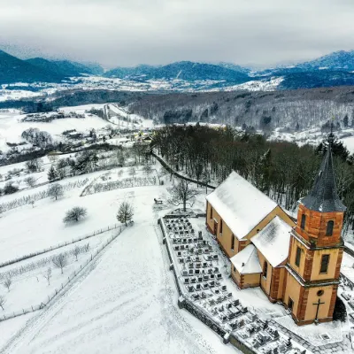
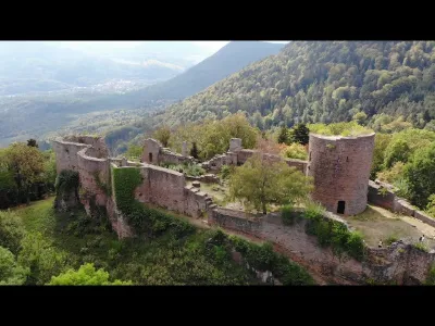
The Falkenstein Rock is easily accessible by car by parking in the "Parking Pour Rocher Falkenstein" located in the middle of the forest and accessible by a carriage road from the D203 coming from Blienschwiller just before the crossroads with the D253. It will take about 40-45 minutes to walk with a good climb for the first 10 minutes and then the terrain will be relatively flat. The site offers a superb view of the Val de Villé. The rock is a climbing site. You'll get great shots of climbers in action, especially towards the end of the day. Quite busy during the day so if you want to be quiet come early in the morning or at the end of the day, the pictures will be even more beautiful.
Map and restricted areas
Open in the main mapNearby aerodromes
Open aerodromes within 25 km of the spot, heliports included, with their distance and direction from the spot. Near an aerodrome, drone flying is prohibited or height-limited: check the UAS zones map.
| Aerodrome | Type | Distance | Elevation | Difference |
|---|---|---|---|---|
| Aérodrome d'Albé - Val de Villé | Aerodrome | 5.2 km NW | 380 m | spot 135 m higher |
| Club ULM de Kogenheim | Aerodrome | 12 km E | 161 m | spot 354 m higher |
| Envol ULM Alsace | Aerodrome | 22 km SE | 176 m | spot 339 m higher |
| Colmar-Houssen Airport | Airport | 23 km S | 191 m | spot 323 m higher |
Aviation weather (METAR and TAF)
LFGA – Colmar-Houssen Airport VFR
METAR
METAR LFGA 211100Z AUTO VRB02KT 9999 FEW013 BKN037 OVC043 08/06 Q1020
- Wind
- Variable, 4 km/h
- Visibility
- 10 km or more
- Clouds
- Few (1-2/8) at 1,300 ft (400 m) ; Broken (5-7/8) at 3,700 ft (1130 m) ; Overcast (8/8) at 4,300 ft (1310 m)
- Temperature
- 8 °C, dew point 6 °C
- QNH
- 1020 hPa
- Flight category
- VFR: ceiling > 3,000 ft and visibility > 5 mi
TAF
Weather and Kp index
| Day | Weather | Temp. min. / max. | Wind | Rain | Max Kp |
|---|---|---|---|---|---|
| Sat 21 Nov | Light rain | 2° / 8° | 5 km/h N | 1.5 mm | 2 |
| Sun 22 Nov | Heavy rain | 2° / 3° | 13 km/h N | 14 mm | 2 |
| Mon 23 Nov | Cloudy | -4° / 2° | 15 km/h N | – | 4 |
| Tue 24 Nov | Clear sky | -5° / 1° | 8 km/h NE | – | 2 |
| Wed 25 Nov | Fair | -5° / 1° | 9 km/h N | 0.1 mm | – |
| Thu 26 Nov | Snow | -3° / -1° | 6 km/h N | 3.5 mm | – |
| Fri 27 Nov | Cloudy | -1° / 3° | 2 km/h SW | – | – |
Hour by hour: Saturday 21 November
| Time | Weather | Temp. | Wind | Rain | Clouds | Kp |
|---|---|---|---|---|---|---|
| 12:00 | Light rain | 7° | 4 km/h SE | 0.3 mm | 97 % | 2 |
| 13:00 | Light rain | 7° | 4 km/h SE | 0.4 mm | 94 % | 1 |
| 14:00 | Rain | 8° | 4 km/h E | 0.5 mm | 90 % | 1 |
| 15:00 | Showers | 7° | 4 km/h E | 0.3 mm | 37 % | 1 |
| 16:00 | Partly cloudy | 6° | 2 km/h E | – | 73 % | 2 |
| 17:00 | Partly cloudy | 5° | 4 km/h NE | – | 83 % | 2 |
| 18:00 | Cloudy | 5° | 5 km/h N | – | 98 % | 2 |
| 19:00 | Cloudy | 4° | 3 km/h NW | – | 99 % | 2 |
| 20:00 | Fog | 4° | 4 km/h NW | – | 96 % | 2 |
| 21:00 | Fog | 3° | 4 km/h NW | – | 94 % | 2 |
| 22:00 | Fog | 2° | 3 km/h NW | – | 82 % | 2 |
Hour by hour: Sunday 22 November
| Time | Weather | Temp. | Wind | Rain | Clouds | Kp |
|---|---|---|---|---|---|---|
| 06:00 | Fog | 2° | 4 km/h NW | – | 100 % | 2 |
| 07:00 | Fog | 2° | 3 km/h NW | – | 100 % | 2 |
| 08:00 | Light rain | 2° | 5 km/h NE | 0.1 mm | 100 % | 2 |
| 09:00 | Light rain | 2° | 5 km/h NE | 0.3 mm | 100 % | 2 |
| 10:00 | Rain | 2° | 5 km/h N | 0.4 mm | 100 % | 2 |
| 11:00 | Rain | 3° | 4 km/h NE | 0.9 mm | 100 % | 2 |
| 12:00 | Heavy rain | 3° | 4 km/h E | 1.6 mm | 100 % | 2 |
| 13:00 | Heavy rain | 3° | 4 km/h SE | 1.8 mm | 100 % | 2 |
| 14:00 | Heavy rain | 3° | 5 km/h E | 1.6 mm | 100 % | 2 |
| 15:00 | Heavy rain | 3° | 6 km/h E | 1.3 mm | 100 % | 2 |
| 16:00 | Heavy rain | 3° | 5 km/h NE | 1.3 mm | 100 % | 2 |
| 17:00 | Heavy rain | 3° | 6 km/h N | 1.3 mm | 100 % | 2 |
| 18:00 | Heavy rain | 3° | 9 km/h N | 1.1 mm | 100 % | 2 |
| 19:00 | Rain | 3° | 9 km/h N | 1.0 mm | 100 % | 2 |
| 20:00 | Rain | 3° | 9 km/h N | 0.7 mm | 100 % | 2 |
| 21:00 | Light rain | 3° | 10 km/h N | 0.3 mm | 100 % | 2 |
| 22:00 | Light rain | 3° | 12 km/h N | 0.1 mm | 100 % | 2 |
Sunrise and sunset
| Day | Dawn | Sunrise | Golden hour | Sunset | Dusk | Day length |
|---|---|---|---|---|---|---|
| Sat 21 Nov | 07:12 | 07:47 | 07:47–08:37 · 15:56–16:46 | 16:46 | 17:21 | 8 h 59 |
| Sun 22 Nov | 07:13 | 07:48 | 07:48–08:38 · 15:55–16:45 | 16:45 | 17:20 | 8 h 56 |
| Mon 23 Nov | 07:15 | 07:50 | 07:50–08:40 · 15:54–16:44 | 16:44 | 17:19 | 8 h 54 |
| Tue 24 Nov | 07:16 | 07:51 | 07:51–08:42 · 15:53–16:43 | 16:43 | 17:18 | 8 h 52 |
| Wed 25 Nov | 07:17 | 07:52 | 07:52–08:43 · 15:52–16:43 | 16:43 | 17:18 | 8 h 50 |
| Thu 26 Nov | 07:19 | 07:54 | 07:54–08:45 · 15:51–16:42 | 16:42 | 17:17 | 8 h 47 |
| Fri 27 Nov | 07:20 | 07:55 | 07:55–08:47 · 15:50–16:41 | 16:41 | 17:16 | 8 h 45 |

Reviews
Log in to review this spot. Log in · Create a free account
No reviews yet. Share yours!