

Oisème
No reviews yet
Have you flown here? Share your experience with other pilots.
+ Write the first reviewDescription
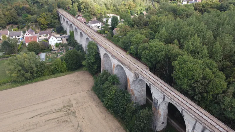
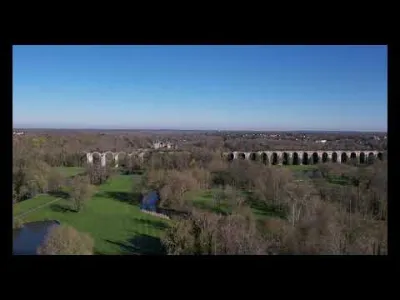
Its construction began in 1907 and lasted 6 years. A majestic structure 260 meters long, it rests on 18 stone arches spanning the Roguenette valley. It only opened to rail traffic in 1930 because of the First World War and numerous strikes. Three trains used it daily in each direction, serving the stations of Sennainville/Champseru – Coltainville – Oisème and Champhol between Gallardon and Chartres. The line did not continue to Paris. The last station was Massy Palaiseau, and you had to take another train to continue your journey. The line was closed in 1939 and the Oisème station was never completed. The bombing of the viaduct by American troops after the landing, on June 25, 1944, killed 6 people and destroyed 3 arches, which were rebuilt after the war in 1946. Today, no trains run on this line anymore.
Map and restricted areas
Open in the main mapNearby aerodromes
Open aerodromes within 25 km of the spot, heliports included, with their distance and direction from the spot. Near an aerodrome, drone flying is prohibited or height-limited: check the UAS zones map.
| Aerodrome | Type | Distance | Elevation | Difference |
|---|---|---|---|---|
| Aérodrome de Chartres-Métropole | Aerodrome | 1.9 km SW | 155 m | spot 32 m lower |
| Centre Hospitalier Heliport | Heliport | 6.4 km S | 149 m | spot 25 m lower |
| Bailleau Armenonville Airfield | Aerodrome | 9.0 km NE | 155 m | spot 32 m lower |
Aviation weather (METAR and TAF)
No METAR station within 50 km.
Weather and Kp index
| Day | Weather | Temp. min. / max. | Wind | Rain | Max Kp |
|---|---|---|---|---|---|
| Sat 21 Nov | Cloudy | 7° / 10° | 15 km/h E | – | 2 |
| Sun 22 Nov | Heavy rain | 7° / 9° | 27 km/h W | 28 mm | 2 |
| Mon 23 Nov | Fair | 1° / 8° | 22 km/h W | 0.5 mm | 4 |
| Tue 24 Nov | Clear sky | -3° / 3° | 17 km/h E | – | 2 |
| Wed 25 Nov | Sleet | -1° / 2° | 17 km/h NE | 2.3 mm | – |
| Thu 26 Nov | Clear sky | -3° / 1° | 13 km/h NE | – | – |
| Fri 27 Nov | Light rain | -4° / 5° | 18 km/h S | 4.0 mm | – |
Hour by hour: Saturday 21 November
| Time | Weather | Temp. | Wind | Rain | Clouds | Kp |
|---|---|---|---|---|---|---|
| 07:00 | Fog | 7° | 8 km/h SW | – | 100 % | 2 |
| 08:00 | Fog | 8° | 8 km/h S | – | 100 % | 2 |
| 09:00 | Fog | 8° | 10 km/h S | – | 100 % | 2 |
| 10:00 | Fog | 8° | 9 km/h S | – | 100 % | 2 |
| 11:00 | Cloudy | 9° | 10 km/h S | – | 100 % | 2 |
| 12:00 | Cloudy | 9° | 10 km/h S | – | 100 % | 2 |
| 13:00 | Cloudy | 9° | 11 km/h S | – | 100 % | 1 |
| 14:00 | Cloudy | 10° | 12 km/h S | – | 100 % | 1 |
| 15:00 | Cloudy | 10° | 11 km/h SE | – | 100 % | 1 |
| 16:00 | Cloudy | 10° | 12 km/h S | – | 100 % | 2 |
| 17:00 | Cloudy | 10° | 8 km/h SE | – | 100 % | 2 |
| 18:00 | Cloudy | 9° | 9 km/h SE | – | 100 % | 2 |
| 19:00 | Cloudy | 9° | 10 km/h SE | – | 100 % | 2 |
| 20:00 | Cloudy | 9° | 11 km/h E | – | 100 % | 2 |
| 21:00 | Cloudy | 8° | 13 km/h E | – | 100 % | 2 |
| 22:00 | Cloudy | 8° | 14 km/h E | – | 100 % | 2 |
Hour by hour: Sunday 22 November
| Time | Weather | Temp. | Wind | Rain | Clouds | Kp |
|---|---|---|---|---|---|---|
| 06:00 | Rain | 7° | 17 km/h E | 0.5 mm | 100 % | 2 |
| 07:00 | Rain | 7° | 17 km/h E | 1.0 mm | 100 % | 2 |
| 08:00 | Heavy rain | 7° | 14 km/h E | 1.3 mm | 100 % | 2 |
| 09:00 | Heavy rain | 7° | 14 km/h E | 1.2 mm | 100 % | 2 |
| 10:00 | Heavy rain | 7° | 14 km/h E | 1.4 mm | 100 % | 2 |
| 11:00 | Heavy rain | 7° | 12 km/h E | 1.8 mm | 100 % | 2 |
| 12:00 | Heavy rain | 8° | 11 km/h E | 2.2 mm | 100 % | 2 |
| 13:00 | Heavy rain | 7° | 14 km/h E | 2.4 mm | 100 % | 2 |
| 14:00 | Heavy rain | 8° | 14 km/h E | 2.9 mm | 100 % | 2 |
| 15:00 | Heavy rain | 8° | 8 km/h NE | 2.2 mm | 100 % | 2 |
| 16:00 | Heavy rain | 8° | 11 km/h N | 2.1 mm | 100 % | 2 |
| 17:00 | Heavy rain | 8° | 10 km/h NE | 2.5 mm | 100 % | 2 |
| 18:00 | Heavy rain | 7° | 8 km/h SW | 2.3 mm | 100 % | 2 |
| 19:00 | Heavy rain | 8° | 24 km/h SW | 1.1 mm | 100 % | 2 |
| 20:00 | Light rain | 9° | 27 km/h W | 0.4 mm | 100 % | 2 |
| 21:00 | Light rain | 9° | 25 km/h W | 0.3 mm | 100 % | 2 |
| 22:00 | Light rain | 9° | 23 km/h W | 0.1 mm | 100 % | 2 |
Sunrise and sunset
| Day | Dawn | Sunrise | Golden hour | Sunset | Dusk | Day length |
|---|---|---|---|---|---|---|
| Sat 21 Nov | 07:36 | 08:11 | 08:11–09:01 · 16:18–17:09 | 17:09 | 17:44 | 8 h 58 |
| Sun 22 Nov | 07:37 | 08:12 | 08:12–09:03 · 16:17–17:08 | 17:08 | 17:43 | 8 h 55 |
| Mon 23 Nov | 07:39 | 08:14 | 08:14–09:04 · 16:16–17:07 | 17:07 | 17:42 | 8 h 53 |
| Tue 24 Nov | 07:40 | 08:15 | 08:15–09:06 · 16:15–17:06 | 17:06 | 17:41 | 8 h 51 |
| Wed 25 Nov | 07:41 | 08:16 | 08:16–09:08 · 16:14–17:05 | 17:05 | 17:40 | 8 h 48 |
| Thu 26 Nov | 07:42 | 08:18 | 08:18–09:09 · 16:13–17:05 | 17:05 | 17:40 | 8 h 46 |
| Fri 27 Nov | 07:44 | 08:19 | 08:19–09:11 · 16:12–17:04 | 17:04 | 17:39 | 8 h 44 |



Reviews
Log in to review this spot. Log in · Create a free account
No reviews yet. Share yours!