

ÎLES SANGUINAIRES-Pointe de la Parata

No reviews yet
Have you flown here? Share your experience with other pilots.
+ Write the first reviewDescription
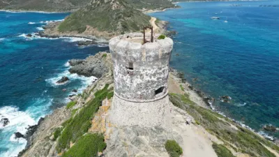
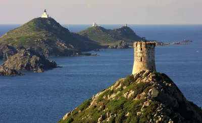
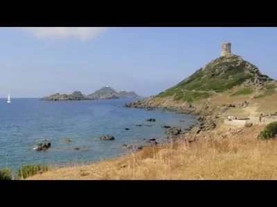
Described as the "figurehead" of the Gulf of Ajaccio, the Sanguinaires archipelago tells visitors coming from the sea, as well as travelers arriving by air, that they are close to reaching Ajaccio. Whether you arrive by road or by sea, the site gradually reveals itself along the way. It is the end point of the ridge line overlooking the northern shore of the Gulf of Ajaccio. Its coastal landscape, backed by the mountain, is enlivened by a succession of highlights and focal points, emphasized by perched structures: towers, a lighthouse, a semaphore station. Made up of rugged and relatively narrow terrain, the only part of the site with some depth is Cala di Reta. Areas not served by walking trails are inaccessible because of very dense maquis scrubland. A legendary name, Les Sanguinaires: This place, commonly called the Sanguinaires, takes its name from many legends. Some do not match the historical timeline or proven historical events, so they are not retained. This mythical name, which has inspired many poets, could therefore be due to the color of the setting sun on the red granite rocks, or to the red of the frankenia leaves or the pink of the snowflake flowers, or even be a distortion of the name "Sagone," designating a gulf north of the islands. This last hypothesis seems the most plausible, as several 17th-century maps call them "sagonare insulae," meaning "the islands that announce the Gulf of Sagone." source : https://www.grandsitesanguinaires-parata.com/esprit-des-lieux/
Map and restricted areas
Open in the main mapNearby aerodromes
Open aerodromes within 25 km of the spot, heliports included, with their distance and direction from the spot. Near an aerodrome, drone flying is prohibited or height-limited: check the UAS zones map.
| Aerodrome | Type | Distance | Elevation | Difference |
|---|---|---|---|---|
| Ajaccio-Napoléon Bonaparte Airport | Airport | 16 km E | 5 m | spot 9 m higher |
Aviation weather (METAR and TAF)
LFKJ – Ajaccio-Napoléon Bonaparte Airport VFR
METAR
METAR LFKJ 210800Z AUTO 04003KT 010V090 9999 BKN037 BKN047 BKN054 14/11 Q1020 NOSIG
- Wind
- 040°, 6 km/h
- Visibility
- 10 km or more
- Clouds
- Broken (5-7/8) at 3,700 ft (1130 m) ; Broken (5-7/8) at 4,700 ft (1430 m) ; Broken (5-7/8) at 5,400 ft (1650 m)
- Temperature
- 14 °C, dew point 11 °C
- QNH
- 1020 hPa
- Flight category
- VFR: ceiling > 3,000 ft and visibility > 5 mi
TAF
TAF LFKJ 210200Z 2103/2203 06004KT 9999 BKN035 BECMG 2110/2112 24010KT BECMG 2116/2118 05005KT
| Period (local time) | Change | Wind | Visibility | Weather | Clouds |
|---|---|---|---|---|---|
| 21/11 04:00 → 21/11 11:00 | Initial conditions | 060°, 7 km/h | 10 km or more | Broken (5-7/8) at 3,500 ft (1070 m) | |
| 21/11 11:00 → 21/11 17:00 | Becoming | 240°, 19 km/h | 10 km or more | Broken (5-7/8) at 3,500 ft (1070 m) | |
| 21/11 17:00 → 22/11 04:00 | Becoming | 050°, 9 km/h | 10 km or more | Broken (5-7/8) at 3,500 ft (1070 m) |
Weather and Kp index
Sunrise and sunset
| Day | Dawn | Sunrise | Golden hour | Sunset | Dusk | Day length |
|---|---|---|---|---|---|---|
| Sat 21 Nov | 06:52 | 07:22 | 07:22–08:05 · 16:18–17:00 | 17:00 | 17:31 | 9 h 38 |
| Sun 22 Nov | 06:53 | 07:24 | 07:24–08:06 · 16:17–17:00 | 17:00 | 17:30 | 9 h 36 |
| Mon 23 Nov | 06:54 | 07:25 | 07:25–08:08 · 16:16–16:59 | 16:59 | 17:30 | 9 h 34 |
| Tue 24 Nov | 06:55 | 07:26 | 07:26–08:09 · 16:16–16:59 | 16:59 | 17:29 | 9 h 32 |
| Wed 25 Nov | 06:56 | 07:27 | 07:27–08:10 · 16:15–16:58 | 16:58 | 17:29 | 9 h 31 |
| Thu 26 Nov | 06:58 | 07:28 | 07:28–08:11 · 16:14–16:58 | 16:58 | 17:28 | 9 h 29 |
| Fri 27 Nov | 06:59 | 07:29 | 07:29–08:13 · 16:14–16:57 | 16:57 | 17:28 | 9 h 27 |


Reviews
Log in to review this spot. Log in · Create a free account
No reviews yet. Share yours!