

Saumonards Fort
No reviews yet
Have you flown here? Share your experience with other pilots.
+ Write the first reviewDescription
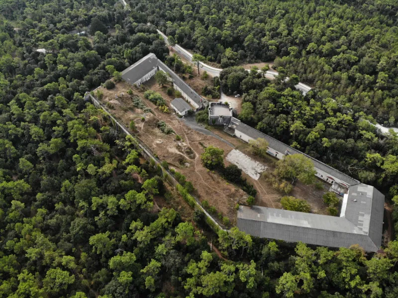
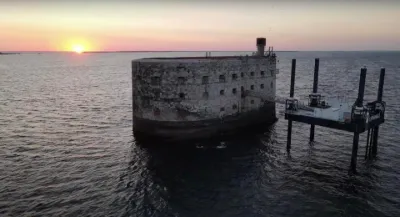
Together with the forts on the mainland and above all Fort Boyard, the Saumonards forts were meant to lock down the straits and prevent "Perfidious Albion" from once again threatening the safety of the French fleet's ships, as it had in fact been doing for centuries. Thanks to the innovations of the Corps of Engineers, honored under the First Empire, these two structures were set to revolutionize the techniques and practices in use for building military works, notably with the model towers, those fully self-sufficient fortified retreat points and other compact structures that would inspire, among others, the famous blockhouses of the Atlantic Wall for the German officers held prisoner in 14/18.
Quickly overtaken by the constant progress of the art of fortification, they soon became obsolete, notably because of advances in artillery. These forts bore different names depending on the era: Napoléon or de la Galissonnière for the one located deepest in the forest, Panorama or de la Pointe de la Perrotine for the one close to the Boyard channel.
You can still admire the outlines and walk along the walls of these forts, which have had very different fates: the former Fort Panorama, which no longer had a military function at the beginning of the 20th century, was a German prisoner camp during the First World War and was then acquired by the Departmental Council in the 21st century. Today it hosts students from schools in the department, and training camps for sports associations.
The second, which was also a prison during the First World War, was sold in early 2019 by the Domaines to Xavier Niel, of the Free group. It could become a training center for the famous buying group, unless it becomes a fitness center…
Map and restricted areas
Open in the main mapNearby aerodromes
Open aerodromes within 25 km of the spot, heliports included, with their distance and direction from the spot. Near an aerodrome, drone flying is prohibited or height-limited: check the UAS zones map.
| Aerodrome | Type | Distance | Elevation | Difference |
|---|---|---|---|---|
| St Pierre d'Oléron Airfield | Aerodrome | 6.2 km SW | 6 m | same altitude as the spot |
| Centre Hospitalier Heliport | Heliport | 21 km NE | 15 m | spot 5 m lower |
| La Rochelle-Île de Ré Airport | Airport | 22 km N | 23 m | spot 13 m lower |
| Aérodrome de Marennes - Le Bournet | Aerodrome | 22 km SE | 5 m | spot 5 m higher |
| Rochefort-Saint-Agnant (BA 721) Airport | Airport | 23 km SE | 18 m | spot 9 m lower |
Aviation weather (METAR and TAF)
LFBH – La Rochelle-Île de Ré Airport LIFR
METAR
METAR LFBH 211030Z AUTO 13012KT 9999 OVC004 12/11 Q1016 BECMG NSC
- Wind
- 130°, 22 km/h
- Visibility
- 10 km or more
- Clouds
- Overcast (8/8) at 400 ft (120 m)
- Temperature
- 12 °C, dew point 11 °C
- QNH
- 1016 hPa
- Flight category
- LIFR: ceiling < 500 ft or visibility < 1 mi
TAF
TAF LFBH 210500Z 2106/2206 13005KT 3000 BR OVC002 TEMPO 2106/2110 0300 FG VV/// BECMG 2110/2113 CAVOK TEMPO 2116/2119 4000 -RA BECMG 2119/2121 4000 -RA BKN012 TEMPO 2121/2201 2500 DZRA BKN004 OVC012 TEMPO 2201/2203 16020G35KT 2500 RA BKN004 SCT030CB FM220300 25015G25KT 9999 SCT015 TEMPO 2203/2206 25020G40KT 3000 SHRA BKN020CB
| Period (local time) | Change | Wind | Visibility | Weather | Clouds |
|---|---|---|---|---|---|
| 21/11 07:00 → 21/11 11:00 | Initial conditions | 130°, 9 km/h | 3.0 km | Mist | Overcast (8/8) at 200 ft (60 m) |
| 21/11 07:00 → 21/11 11:00 | Temporarily | 300 m | Fog | ||
| 21/11 11:00 → 21/11 20:00 | Becoming | 130°, 9 km/h | 10 km or more | No significant weather | No significant cloud |
| 21/11 17:00 → 21/11 20:00 | Temporarily | 4.0 km | Rain light | ||
| 21/11 20:00 → 22/11 04:00 | Becoming | 130°, 9 km/h | 4.0 km | Rain light | Broken (5-7/8) at 1,200 ft (370 m) |
| 21/11 22:00 → 22/11 02:00 | Temporarily | 2.5 km | Drizzle ; rain | Broken (5-7/8) at 400 ft (120 m) ; Overcast (8/8) at 1,200 ft (370 m) | |
| 22/11 02:00 → 22/11 04:00 | Temporarily | 160°, 37 km/h, gusts 65 km/h | 2.5 km | Rain | Broken (5-7/8) at 400 ft (120 m) ; Scattered (3-4/8) at 3,000 ft (910 m) (cumulonimbus) |
| 22/11 04:00 → 22/11 07:00 | From | 250°, 28 km/h, gusts 46 km/h | 10 km or more | Scattered (3-4/8) at 1,500 ft (460 m) | |
| 22/11 04:00 → 22/11 07:00 | Temporarily | 250°, 37 km/h, gusts 74 km/h | 3.0 km | Showers of rain | Broken (5-7/8) at 2,000 ft (610 m) (cumulonimbus) |
Weather and Kp index
| Day | Weather | Temp. min. / max. | Wind | Rain | Max Kp |
|---|---|---|---|---|---|
| Sat 21 Nov | Cloudy | 13° / 15° | 36 km/h S | 4.9 mm | 2 |
| Sun 22 Nov | Showers | 13° / 15° | 58 km/h W | 14 mm | 2 |
| Mon 23 Nov | Partly cloudy | 11° / 14° | 39 km/h NW | 0.4 mm | 4 |
| Tue 24 Nov | Cloudy | 8° / 10° | 20 km/h SE | 0.4 mm | 2 |
| Wed 25 Nov | Light rain | 11° / 13° | 26 km/h SE | 7.1 mm | – |
| Thu 26 Nov | Cloudy | 8° / 10° | 22 km/h NE | 0.8 mm | – |
| Fri 27 Nov | Light rain | 9° / 13° | 28 km/h S | 3.5 mm | – |
Hour by hour: Saturday 21 November
| Time | Weather | Temp. | Wind | Rain | Clouds | Kp |
|---|---|---|---|---|---|---|
| 12:00 | Cloudy | 14° | 26 km/h SE | – | 100 % | 2 |
| 13:00 | Cloudy | 14° | 25 km/h SE | – | 100 % | 1 |
| 14:00 | Cloudy | 15° | 23 km/h SE | – | 100 % | 1 |
| 15:00 | Cloudy | 15° | 28 km/h SE | – | 100 % | 1 |
| 16:00 | Cloudy | 15° | 29 km/h SE | – | 100 % | 2 |
| 17:00 | Rain | 15° | 30 km/h SE | 0.9 mm | 100 % | 2 |
| 18:00 | Rain | 14° | 28 km/h SE | 1.0 mm | 100 % | 2 |
| 19:00 | Rain | 13° | 27 km/h SE | 0.7 mm | 100 % | 2 |
| 20:00 | Light rain | 13° | 29 km/h SE | 0.3 mm | 100 % | 2 |
| 21:00 | Light rain | 13° | 33 km/h SE | 0.3 mm | 100 % | 2 |
| 22:00 | Rain | 13° | 36 km/h S | 0.6 mm | 100 % | 2 |
Hour by hour: Sunday 22 November
| Time | Weather | Temp. | Wind | Rain | Clouds | Kp |
|---|---|---|---|---|---|---|
| 06:00 | Showers | 14° | 50 km/h W | 0.4 mm | 41 % | 2 |
| 07:00 | Showers | 13° | 58 km/h W | 0.3 mm | 67 % | 2 |
| 08:00 | Showers | 14° | 51 km/h W | 0.4 mm | 56 % | 2 |
| 09:00 | Showers | 14° | 48 km/h W | 0.4 mm | 23 % | 2 |
| 10:00 | Showers | 14° | 52 km/h W | 0.4 mm | 44 % | 2 |
| 11:00 | Fair | 14° | 49 km/h W | – | 17 % | 2 |
| 12:00 | Clear sky | 14° | 51 km/h W | – | 7 % | 2 |
| 13:00 | Showers | 14° | 54 km/h W | 0.2 mm | 40 % | 2 |
| 14:00 | Showers | 14° | 57 km/h W | 0.2 mm | 39 % | 2 |
| 15:00 | Showers | 14° | 54 km/h W | 0.2 mm | 41 % | 2 |
| 16:00 | Fair | 14° | 46 km/h NW | – | 13 % | 2 |
| 17:00 | Partly cloudy | 14° | 48 km/h NW | – | 48 % | 2 |
| 18:00 | Partly cloudy | 14° | 44 km/h W | – | 46 % | 2 |
| 19:00 | Partly cloudy | 14° | 44 km/h W | – | 61 % | 2 |
| 20:00 | Fair | 14° | 41 km/h W | – | 27 % | 2 |
| 21:00 | Fair | 14° | 41 km/h W | – | 27 % | 2 |
| 22:00 | Clear sky | 14° | 40 km/h W | – | 11 % | 2 |
Sunrise and sunset
| Day | Dawn | Sunrise | Golden hour | Sunset | Dusk | Day length |
|---|---|---|---|---|---|---|
| Sat 21 Nov | 07:41 | 08:14 | 08:14–09:01 · 16:41–17:28 | 17:28 | 18:01 | 9 h 14 |
| Sun 22 Nov | 07:42 | 08:15 | 08:15–09:02 · 16:40–17:27 | 17:27 | 18:00 | 9 h 12 |
| Mon 23 Nov | 07:43 | 08:16 | 08:16–09:04 · 16:39–17:26 | 17:26 | 18:00 | 9 h 10 |
| Tue 24 Nov | 07:44 | 08:18 | 08:18–09:05 · 16:38–17:26 | 17:26 | 17:59 | 9 h 08 |
| Wed 25 Nov | 07:46 | 08:19 | 08:19–09:07 · 16:37–17:25 | 17:25 | 17:58 | 9 h 06 |
| Thu 26 Nov | 07:47 | 08:20 | 08:20–09:08 · 16:37–17:24 | 17:24 | 17:58 | 9 h 04 |
| Fri 27 Nov | 07:48 | 08:21 | 08:21–09:09 · 16:36–17:24 | 17:24 | 17:57 | 9 h 02 |
Reviews
Log in to review this spot. Log in · Create a free account
No reviews yet. Share yours!