

Calotte Saint-Joseph / Langonnet

1 pilot review
“Un lieu très sympa, un soleil magnifique en fin de journée, un peu de vent, bon spot pour…” — cobra_mk3, 5 years ago
Read the reviews + Write my reviewDescription
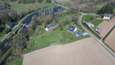
A great spot with a 360° view after a short walk to reach the viewpoint indicator. Depending on the weather, you can get superb views (if there isn't too much wind). The Calotte Saint-Joseph can be reached by car along a small stony road, but it's difficult to turn around once you're at the top.
Map and restricted areas
Open in the main mapNearby aerodromes
Open aerodromes within 25 km of the spot, heliports included, with their distance and direction from the spot. Near an aerodrome, drone flying is prohibited or height-limited: check the UAS zones map.
| Aerodrome | Type | Distance | Elevation | Difference |
|---|---|---|---|---|
| Guiscriff Scaer Airport | Aerodrome | 21 km SW | 175 m | spot 115 m higher |
Aviation weather (METAR and TAF)
LFRH – Lorient South Brittany (Bretagne Sud) Airport IFR
METAR
METAR LFRH 211230Z AUTO 12012KT 090V150 9999 OVC007 12/12 Q1012 BECMG BKN016
- Wind
- 120°, 22 km/h
- Visibility
- 10 km or more
- Clouds
- Overcast (8/8) at 700 ft (210 m)
- Temperature
- 12 °C, dew point 12 °C
- QNH
- 1012 hPa
- Flight category
- IFR: ceiling 500–1,000 ft or visibility 1–3 mi
TAF
TAF LFRH 211100Z 2112/2212 12010KT 9999 OVC005 PROB40 TEMPO 2112/2113 2500 BR BKN002 PROB30 TEMPO 2112/2113 0900 FG VV/// BECMG 2113/2115 BKN016 BECMG 2115/2117 12015G25KT BKN008 TEMPO 2117/2201 2500 RA BKN020CB PROB40 TEMPO 2120/2203 1400 TSRA BKN003 TEMPO 2121/2124 18015G25KT BECMG 2201/2203 25015G25KT BKN016 TEMPO 2201/2212 28020G30KT 3000 SHRA SCT020CB
| Period (local time) | Change | Wind | Visibility | Weather | Clouds |
|---|---|---|---|---|---|
| 21/11 13:00 → 21/11 14:00 | Initial conditions | 120°, 19 km/h | 10 km or more | Overcast (8/8) at 500 ft (150 m) | |
| 21/11 13:00 → 21/11 14:00 | Temporarily, probability 40% | 2.5 km | Mist | Broken (5-7/8) at 200 ft (60 m) | |
| 21/11 13:00 → 21/11 14:00 | Temporarily, probability 30% | 900 m | Fog | ||
| 21/11 14:00 → 21/11 16:00 | Becoming | 120°, 19 km/h | 10 km or more | Broken (5-7/8) at 1,600 ft (490 m) | |
| 21/11 16:00 → 22/11 02:00 | Becoming | 120°, 28 km/h, gusts 46 km/h | 10 km or more | Broken (5-7/8) at 800 ft (240 m) | |
| 21/11 18:00 → 22/11 02:00 | Temporarily | 2.5 km | Rain | Broken (5-7/8) at 2,000 ft (610 m) (cumulonimbus) | |
| 21/11 21:00 → 22/11 04:00 | Temporarily, probability 40% | 1.4 km | Thunderstorm rain | Broken (5-7/8) at 300 ft (90 m) | |
| 21/11 22:00 → 22/11 01:00 | Temporarily | 180°, 28 km/h, gusts 46 km/h | |||
| 22/11 02:00 → 22/11 13:00 | Becoming | 250°, 28 km/h, gusts 46 km/h | 10 km or more | Broken (5-7/8) at 1,600 ft (490 m) | |
| 22/11 02:00 → 22/11 13:00 | Temporarily | 280°, 37 km/h, gusts 56 km/h | 3.0 km | Showers of rain | Scattered (3-4/8) at 2,000 ft (610 m) (cumulonimbus) |
Weather and Kp index
| Day | Weather | Temp. min. / max. | Wind | Rain | Max Kp |
|---|---|---|---|---|---|
| Sat 21 Nov | Cloudy | 10° / 13° | 28 km/h SE | 4.7 mm | 2 |
| Sun 22 Nov | Cloudy | 8° / 12° | 34 km/h W | 6.6 mm | 2 |
| Mon 23 Nov | Partly cloudy | 6° / 13° | 19 km/h W | 0.1 mm | 4 |
| Tue 24 Nov | Partly cloudy | 8° / 10° | 26 km/h SE | 2.0 mm | 2 |
| Wed 25 Nov | Cloudy | 7° / 8° | 21 km/h SE | 4.0 mm | – |
| Thu 26 Nov | Clear sky | 1° / 6° | 16 km/h NE | – | – |
| Fri 27 Nov | Cloudy | -1° / 7° | 24 km/h SE | 5.8 mm | – |
Hour by hour: Saturday 21 November
| Time | Weather | Temp. | Wind | Rain | Clouds | Kp |
|---|---|---|---|---|---|---|
| 13:00 | Cloudy | 12° | 23 km/h SE | – | 89 % | 2 |
| 14:00 | Partly cloudy | 12° | 23 km/h SE | – | 73 % | 2 |
| 15:00 | Cloudy | 13° | 26 km/h SE | – | 98 % | 2 |
| 16:00 | Cloudy | 13° | 25 km/h SE | – | 94 % | 2 |
| 17:00 | Cloudy | 12° | 24 km/h SE | – | 100 % | 2 |
| 18:00 | Cloudy | 11° | 25 km/h SE | – | 100 % | 2 |
| 19:00 | Rain | 11° | 25 km/h SE | 0.4 mm | 100 % | 2 |
| 20:00 | Heavy rain | 11° | 27 km/h SE | 2.3 mm | 100 % | 2 |
| 21:00 | Rain | 10° | 28 km/h SE | 0.7 mm | 100 % | 2 |
| 22:00 | Light rain | 10° | 26 km/h SE | 0.3 mm | 100 % | 2 |
Hour by hour: Sunday 22 November
| Time | Weather | Temp. | Wind | Rain | Clouds | Kp |
|---|---|---|---|---|---|---|
| 06:00 | Light rain | 11° | 21 km/h W | 0.3 mm | 100 % | 2 |
| 07:00 | Light rain | 10° | 27 km/h W | 0.3 mm | 100 % | 2 |
| 08:00 | Light rain | 10° | 29 km/h W | 0.3 mm | 100 % | 2 |
| 09:00 | Light rain | 10° | 31 km/h W | 0.2 mm | 99 % | 2 |
| 10:00 | Light rain | 10° | 31 km/h W | 0.2 mm | 98 % | 2 |
| 11:00 | Rain | 10° | 31 km/h W | 0.6 mm | 98 % | 2 |
| 12:00 | Rain | 10° | 32 km/h W | 0.4 mm | 94 % | 2 |
| 13:00 | Cloudy | 11° | 34 km/h W | – | 93 % | 2 |
| 14:00 | Showers | 12° | 31 km/h W | 0.1 mm | 58 % | 2 |
| 15:00 | Partly cloudy | 12° | 33 km/h W | – | 48 % | 2 |
| 16:00 | Fair | 11° | 30 km/h W | – | 27 % | 2 |
| 17:00 | Fair | 10° | 27 km/h W | – | 15 % | 2 |
| 18:00 | Clear sky | 9° | 25 km/h W | – | 4 % | 2 |
| 19:00 | Clear sky | 9° | 23 km/h W | – | 5 % | 2 |
| 20:00 | Clear sky | 9° | 22 km/h W | – | 4 % | 2 |
| 21:00 | Clear sky | 8° | 21 km/h W | – | 2 % | 2 |
| 22:00 | Clear sky | 8° | 20 km/h W | – | 3 % | 2 |
Sunrise and sunset
| Day | Dawn | Sunrise | Golden hour | Sunset | Dusk | Day length |
|---|---|---|---|---|---|---|
| Sat 21 Nov | 07:55 | 08:30 | 08:30–09:19 · 16:40–17:30 | 17:30 | 18:04 | 9 h 00 |
| Sun 22 Nov | 07:56 | 08:31 | 08:31–09:21 · 16:39–17:29 | 17:29 | 18:03 | 8 h 57 |
| Mon 23 Nov | 07:58 | 08:32 | 08:32–09:23 · 16:38–17:28 | 17:28 | 18:03 | 8 h 55 |
| Tue 24 Nov | 07:59 | 08:34 | 08:34–09:24 · 16:37–17:27 | 17:27 | 18:02 | 8 h 53 |
| Wed 25 Nov | 08:00 | 08:35 | 08:35–09:26 · 16:36–17:26 | 17:26 | 18:01 | 8 h 51 |
| Thu 26 Nov | 08:02 | 08:37 | 08:37–09:28 · 16:35–17:26 | 17:26 | 18:01 | 8 h 48 |
| Fri 27 Nov | 08:03 | 08:38 | 08:38–09:29 · 16:34–17:25 | 17:25 | 18:00 | 8 h 46 |





Reviews
Log in to review this spot. Log in · Create a free account
cobra_mk3
Un lieu très sympa, un soleil magnifique en fin de journée, un peu de vent, bon spot pour ses premières fois ;-)