

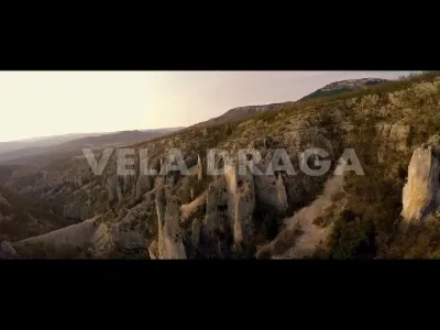
Vela Draga canyon
No reviews yet
Have you flown here? Share your experience with other pilots.
+ Write the first reviewDescription
Vela draga also known as Valle delle meraviglie located in Istria near tunnel Ucka ( Croatia ) Vela Draga is famous for its geological fenomena, impressive rocks and limestone towers up to 100 m high ,also presents one of the most beautiful climbing grounds in Croatia for free climbers,alpinist ... For more info: http://www.geocaching.com/geocache/GC2BXNZ_vela-draga?guid=4b6d6437-f032-4ce4-b63a-d4d7fc2bca1c
Music:Infinity from album Emerge by Icon Audio Support IconAudio music and buy his album: https://iconaudio.bandcamp.com/ https://www.youtube.com/channel/UC2IJ-eMFnrYmeKpTnb39G1g https://soundcloud.com/iconaudio https://www.facebook.com/IconicAudio1
If you like this video share and subscribe! --------------------------------------------------------
Map and restricted areas
Open in the main mapAviation weather (METAR and TAF)
LDRI – Rijeka Airport VFR
METAR
METAR LDRI 211100Z 24004KT 190V310 9999 FEW030 15/08 Q1016
- Wind
- 240°, 7 km/h
- Visibility
- 10 km or more
- Clouds
- Few (1-2/8) at 3,000 ft (910 m)
- Temperature
- 15 °C, dew point 8 °C
- QNH
- 1016 hPa
- Flight category
- VFR: ceiling > 3,000 ft and visibility > 5 mi
TAF
TAF LDRI 210525Z 2106/2206 VRB02KT 9999 SCT040 TX15/2113Z TN09/2205Z PROB30 2201/2206 BKN013
| Period (local time) | Change | Wind | Visibility | Weather | Clouds |
|---|---|---|---|---|---|
| 21/11 07:00 → 22/11 07:00 | Initial conditions | Variable, 4 km/h | 10 km or more | Scattered (3-4/8) at 4,000 ft (1220 m) | |
| 22/11 02:00 → 22/11 07:00 | probability 30% | Broken (5-7/8) at 1,300 ft (400 m) |
Weather and Kp index
Sunrise and sunset
| Day | Dawn | Sunrise | Golden hour | Sunset | Dusk | Day length |
|---|---|---|---|---|---|---|
| Sat 21 Nov | 06:37 | 07:10 | 07:10–07:56 · 15:42–16:28 | 16:28 | 17:01 | 9 h 18 |
| Sun 22 Nov | 06:39 | 07:11 | 07:11–07:57 · 15:41–16:28 | 16:28 | 17:00 | 9 h 16 |
| Mon 23 Nov | 06:40 | 07:12 | 07:12–07:59 · 15:40–16:27 | 16:27 | 17:00 | 9 h 14 |
| Tue 24 Nov | 06:41 | 07:14 | 07:14–08:00 · 15:40–16:26 | 16:26 | 16:59 | 9 h 12 |
| Wed 25 Nov | 06:42 | 07:15 | 07:15–08:02 · 15:39–16:26 | 16:26 | 16:58 | 9 h 10 |
| Thu 26 Nov | 06:43 | 07:16 | 07:16–08:03 · 15:38–16:25 | 16:25 | 16:58 | 9 h 08 |
| Fri 27 Nov | 06:45 | 07:17 | 07:17–08:05 · 15:37–16:24 | 16:24 | 16:57 | 9 h 06 |

Reviews
Log in to review this spot. Log in · Create a free account
No reviews yet. Share yours!