

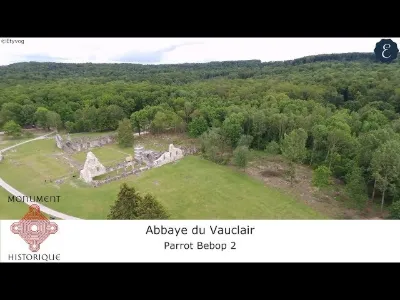
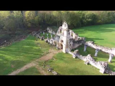
Ruins of the former Vauclair abbey.
No reviews yet
Have you flown here? Share your experience with other pilots.
+ Write the first reviewDescription
This Vauclair abbey, located in the Aisne department on the outskirts of the town of Bouconville-Vauclair, is full of history. It was a Cistercian monks' abbey built in 1134, located north of the Chemin des Dames, where it was destroyed in 1917 during an offensive in the First World War. Today it has been listed as a historic monument since January 1970.
Map and restricted areas
Open in the main mapNearby aerodromes
Open aerodromes within 25 km of the spot, heliports included, with their distance and direction from the spot. Near an aerodrome, drone flying is prohibited or height-limited: check the UAS zones map.
| Aerodrome | Type | Distance | Elevation | Difference |
|---|---|---|---|---|
| Base ULM de Ployart | Aerodrome | 5.8 km N | 177 m | spot 88 m lower |
| Base ULM Azur | Aerodrome | 7.3 km E | 73 m | spot 16 m higher |
| Base ULM de Corbeny | Aerodrome | 7.7 km E | 70 m | spot 19 m higher |
| Laon - Chambry Airfield | Aerodrome | 18 km NW | 78 m | spot 11 m higher |
| Base ULM Avaux - Les Bourdons | Aerodrome | 24 km E | 114 m | spot 25 m lower |
Aviation weather (METAR and TAF)
LFQA – Aérodrome de Reims Prunay MVFR
METAR
METAR LFQA 211100Z AUTO 10003KT 060V140 8000 1200NW SCT013 BKN069 07/05 Q1020
- Wind
- 100°, 6 km/h
- Visibility
- 8 km
- Clouds
- Scattered (3-4/8) at 1,300 ft (400 m) ; Broken (5-7/8) at 6,900 ft (2100 m)
- Temperature
- 7 °C, dew point 5 °C
- QNH
- 1020 hPa
- Flight category
- MVFR: ceiling 1,000–3,000 ft or visibility 3–5 mi
TAF
Weather and Kp index
Sunrise and sunset
| Day | Dawn | Sunrise | Golden hour | Sunset | Dusk | Day length |
|---|---|---|---|---|---|---|
| Sat 21 Nov | 07:30 | 08:05 | 08:05–08:57 · 16:05–16:56 | 16:56 | 17:32 | 8 h 51 |
| Sun 22 Nov | 07:31 | 08:07 | 08:07–08:59 · 16:03–16:55 | 16:55 | 17:31 | 8 h 48 |
| Mon 23 Nov | 07:32 | 08:08 | 08:08–09:01 · 16:02–16:55 | 16:55 | 17:30 | 8 h 46 |
| Tue 24 Nov | 07:34 | 08:10 | 08:10–09:02 · 16:01–16:54 | 16:54 | 17:30 | 8 h 43 |
| Wed 25 Nov | 07:35 | 08:11 | 08:11–09:04 · 16:00–16:53 | 16:53 | 17:29 | 8 h 41 |
| Thu 26 Nov | 07:36 | 08:13 | 08:13–09:06 · 15:59–16:52 | 16:52 | 17:28 | 8 h 39 |
| Fri 27 Nov | 07:38 | 08:14 | 08:14–09:07 · 15:58–16:51 | 16:51 | 17:28 | 8 h 37 |




Reviews
Log in to review this spot. Log in · Create a free account
No reviews yet. Share yours!