

Noyen sur seine
No reviews yet
Have you flown here? Share your experience with other pilots.
+ Write the first reviewDescription
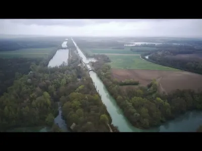
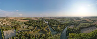
The Bassée project aims to hold back the waters of the Seine when the Yonne flood passes, by pumping river water into storage basins and keeping it there at the flood peak. This facility would consist of storage units filled by pumping. The project covers 2,300 ha of overflow storage areas as close as possible to the confluence, with a storage volume of 55 million m3. The structure would be operated in real time, set at 3 days for river and stream floods. The structure would be used on average every 5 to 6 years for 2 to 2.5 weeks.
Map and restricted areas
Open in the main mapNearby aerodromes
Open aerodromes within 25 km of the spot, heliports included, with their distance and direction from the spot. Near an aerodrome, drone flying is prohibited or height-limited: check the UAS zones map.
| Aerodrome | Type | Distance | Elevation | Difference |
|---|---|---|---|---|
| Pont Sur Yonne Airfield | Aerodrome | 21 km S | 72 m | spot 14 m lower |
Aviation weather (METAR and TAF)
No METAR station within 50 km.
Weather and Kp index
| Day | Weather | Temp. min. / max. | Wind | Rain | Max Kp |
|---|---|---|---|---|---|
| Sat 21 Nov | Cloudy | 7° / 10° | 14 km/h E | – | 2 |
| Sun 22 Nov | Rain | 6° / 8° | 18 km/h E | 11 mm | 2 |
| Mon 23 Nov | Clear sky | -1° / 7° | 20 km/h NE | 4.7 mm | 4 |
| Tue 24 Nov | Cloudy | -3° / 4° | 18 km/h E | – | 2 |
| Wed 25 Nov | Light rain | 0° / 2° | 19 km/h NE | 4.4 mm | – |
| Thu 26 Nov | Clear sky | -2° / 2° | 17 km/h NE | – | – |
| Fri 27 Nov | Fair | -4° / 2° | 10 km/h E | – | – |
Hour by hour: Saturday 21 November
| Time | Weather | Temp. | Wind | Rain | Clouds | Kp |
|---|---|---|---|---|---|---|
| 12:00 | Cloudy | 10° | 9 km/h SW | – | 100 % | 2 |
| 13:00 | Cloudy | 10° | 10 km/h SW | – | 100 % | 1 |
| 14:00 | Cloudy | 10° | 11 km/h SW | – | 98 % | 1 |
| 15:00 | Cloudy | 10° | 9 km/h S | – | 99 % | 1 |
| 16:00 | Partly cloudy | 10° | 8 km/h S | – | 39 % | 2 |
| 17:00 | Cloudy | 9° | 5 km/h E | – | 99 % | 2 |
| 18:00 | Cloudy | 8° | 7 km/h E | – | 98 % | 2 |
| 19:00 | Cloudy | 7° | 8 km/h E | – | 99 % | 2 |
| 20:00 | Cloudy | 8° | 10 km/h E | – | 99 % | 2 |
| 21:00 | Partly cloudy | 7° | 12 km/h E | – | 100 % | 2 |
| 22:00 | Partly cloudy | 7° | 14 km/h E | – | 100 % | 2 |
Hour by hour: Sunday 22 November
| Time | Weather | Temp. | Wind | Rain | Clouds | Kp |
|---|---|---|---|---|---|---|
| 06:00 | Rain | 6° | 17 km/h E | 0.5 mm | 100 % | 2 |
| 07:00 | Rain | 6° | 18 km/h E | 0.5 mm | 100 % | 2 |
| 08:00 | Rain | 6° | 17 km/h E | 0.6 mm | 100 % | 2 |
| 09:00 | Heavy rain | 7° | 14 km/h E | 1.3 mm | 100 % | 2 |
| 10:00 | Rain | 7° | 13 km/h E | 0.9 mm | 100 % | 2 |
| 11:00 | Rain | 7° | 10 km/h E | 0.8 mm | 100 % | 2 |
| 12:00 | Rain | 7° | 10 km/h NE | 1.0 mm | 100 % | 2 |
| 13:00 | Rain | 8° | 8 km/h NE | 0.8 mm | 100 % | 2 |
| 14:00 | Rain | 8° | 9 km/h NE | 0.6 mm | 100 % | 2 |
| 15:00 | Rain | 8° | 9 km/h NE | 0.4 mm | 100 % | 2 |
| 16:00 | Rain | 8° | 9 km/h NE | 0.4 mm | 100 % | 2 |
| 17:00 | Light rain | 7° | 8 km/h NE | 0.3 mm | 100 % | 2 |
| 18:00 | Light rain | 7° | 9 km/h NE | 0.3 mm | 100 % | 2 |
| 19:00 | Light rain | 7° | 6 km/h N | 0.4 mm | 100 % | 2 |
| 20:00 | Light rain | 7° | 4 km/h N | 0.2 mm | 100 % | 2 |
| 21:00 | Light rain | 7° | 3 km/h NW | 0.3 mm | 100 % | 2 |
| 22:00 | Rain | 7° | 2 km/h S | 0.4 mm | 100 % | 2 |
Sunrise and sunset
| Day | Dawn | Sunrise | Golden hour | Sunset | Dusk | Day length |
|---|---|---|---|---|---|---|
| Sat 21 Nov | 07:29 | 08:03 | 08:03–08:54 · 16:11–17:02 | 17:02 | 17:36 | 8 h 58 |
| Sun 22 Nov | 07:30 | 08:05 | 08:05–08:55 · 16:10–17:01 | 17:01 | 17:36 | 8 h 55 |
| Mon 23 Nov | 07:31 | 08:06 | 08:06–08:57 · 16:09–17:00 | 17:00 | 17:35 | 8 h 53 |
| Tue 24 Nov | 07:33 | 08:08 | 08:08–08:59 · 16:08–16:59 | 16:59 | 17:34 | 8 h 51 |
| Wed 25 Nov | 07:34 | 08:09 | 08:09–09:00 · 16:07–16:58 | 16:58 | 17:33 | 8 h 49 |
| Thu 26 Nov | 07:35 | 08:10 | 08:10–09:02 · 16:06–16:57 | 16:57 | 17:33 | 8 h 46 |
| Fri 27 Nov | 07:36 | 08:12 | 08:12–09:03 · 16:05–16:57 | 16:57 | 17:32 | 8 h 44 |


Reviews
Log in to review this spot. Log in · Create a free account
No reviews yet. Share yours!